Updated Sat 11:06 PM: Sunday forecast update is highlighted below:
Following two days of active weather, the forecast for this weekend is straightforward — high pressure builds in, both at the surface and aloft, bringing sunny skies and unseasonably warm (hot) temperatures, a marked change from last weekend.
Indeed, while last weekend featured temperatures in the mid 40s, this weekend, we’ll be catapulted into the low 90s!
Sunny and very warm. High temperature 90.8º sd 2.8º (NBM Blue Bell)
Sunny and hot. High 93.3º sd 3.8º (NBM Blue Bell) High temp still expected to be about 93 ± 2º. Dew points near 62º are beginning to reach a noticeable level, but still not very high. Tonight’s models show the possibility of an isolated thundershower far north of the city late Sundayafternoon.
An increase in the chance of thunderstorms on Monday, mostly west of the city and a significant increase on Tuesday and Wednesday in much of southeastern PA.
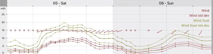
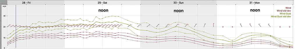
Winds
NBM wind meteogram for Blue Bell, PA (Click on image for larger view)
The forecast trend towards a cloudy, rainy and somewhat chilly Memorial Day Weekend continues. The only bright spot, literally and figuratively, will be Monday.
The current forecast weather setup, first took shape with Wednesday morning’s models. The ICON model was one of the first to pick up on the heavy rain.
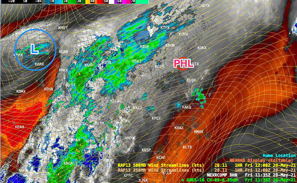
An upper air trough develops over our area Friday through Saturday and lifts out by Monday. The upper trough will pinch into a closed low. Unfortunately, this upper air closed low will be far to our west, putting us in what’s called the “right entrance region” of a strong jet streak on Saturday.
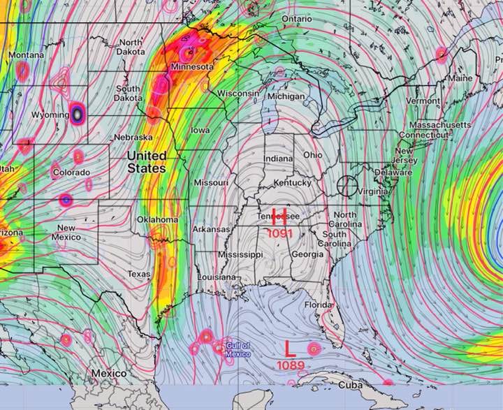
Here’s the current (Friday morning) radar/water-vapor and RAP model jet stream flow showing the developing upper low—
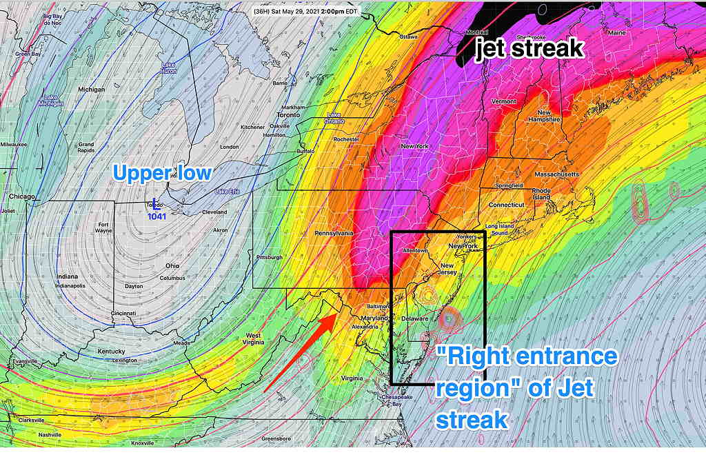
By Saturday, this is the GFS forecast showing the upper low and jet streak entrance region—
GFS Model 250 mb level jet forecast 2 PM Saturday. Note the position of the cold upper air low puts us directly in what’s called the “right entrance region of the jet streak” (The red circles in the entrance region box are areas of strong vertical motion (vorticity) at the jet level.) The southerly flow and orientation of the jet brings in moisture. The vertical motion causes the rain. (Click on image for a larger view.)
A strong moisture flow aloft will result in heavy rain. The latest GFS and NBM have joined the heavy rain forecast of the ICON model. Anywhere from 1.5 – 2 inches of rain now forecast from Friday afternoon through Saturday afternoon.
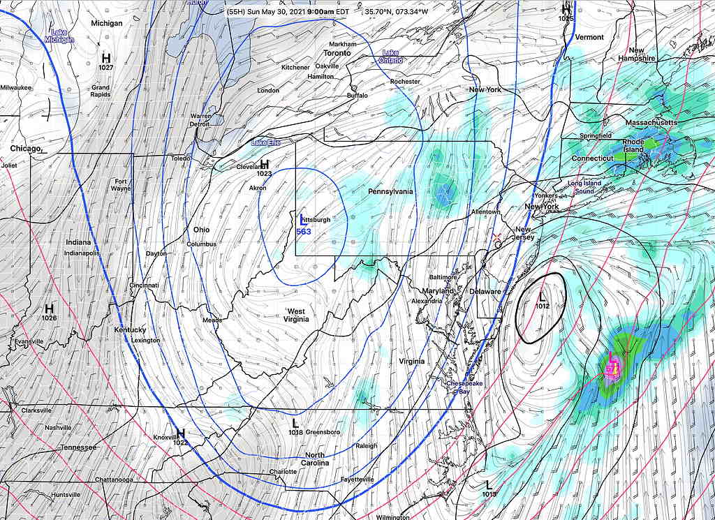
By Sunday morning, the same upper air low will induce the formation of a coastal low resulting in additional light rain, especially Sunday afternoon and evening and especially towards the coast.
GFS surface and 500 mb forecast showing upper low and coastal surface low. More clouds and rain.(Click on image for a larger view.)
Memorial Day Weekend Forecast Details
Friday
Showers may start as early as noon- 2PM Friday, but the heavier rain moves in 3-6 PM Friday.
Saturday
Cloudy with rain early, then intermittent showers. There may be some breaks in the rain at times. It will be chilly with a northeasterly wind. High 54.6º sd 4.2º (NBM Blue Bell)
Sunday
Cloudy with rain. The models are suggesting more rain over the entire area for much of the day on Sunday with the coastal low closer to the coast. An increasing chance of lightRain into the afternoon and evening, especially east into NJ. High 59.2º sd 4.6º (NBM Blue Bell)
Monday
The upper low moves out along with the coastal low Sunday, after midnight, allowing clearing. Partly sunny, some clouds . Milder, but still cool for May. High 72.9º sd 1.8º (NBM Blue Bell)
(The Canadian and ICON models forecast slower clearing with considerable cloudiness lingering on Monday )
Wind Forecast
NBM model Wind/Gust forecast (Click on image for a larger view.)
Updated Sat 8:10 AM highlighted below Updated Fri 7:30 PM highlighted below
There aren’t too many weekends where I can post the forecast on the preceding Thursday and have high confidence that the forecast won’t change appreciably.
We are locked into a dry, unseasonably warm (hot) pattern from a strong upper level ridge of high pressure.
Friday’s models show a weak upper air disturbance rotating through mid to late afternoon Saturday. Some mid level cloudiness Saturday afternoon. A slight chance of a widely scattered shower 3-5 PM ; most areas dry.
Saturday Update: Any showers on Saturday afternoon will be far northwest suburbs, Pottstown north and west.
While the new GFS model has high temperatures in the upper 80s, many models, including the NBM, have highs of 92° on Saturday and 93° on Sunday! Saving us from the summer-like heat will be dew points only in the upper 50s to around 60°.
We could use some rain (of course, never on the weekend), but none is in sight.