Category Archives: Philadelphia Area Weather Forecasts

THIS WEEK’S WEATHER

#weather #paweather #wx #pawx #philadelphia

Thu 8:58 PM Forecast Review —The high temperature in Philadelphia today was 64º and the high temperature in Blue Bell (Wings Field) was 67º. Both were well within the NBM forecast mean and standard deviation. Frankly, I thought the NBM did very well today. (The NBM model was recently updated to version 4.1)

Last night, the broadcast media were forecasting highs of 73º and this morning, they were forecasting highs of 72º. I never heard anything to suggest there was any forecast uncertainty. Perhaps that’s what you get when you only look at the ECMWF forecast?

Thu 10:35 AM Update —Several of this morning’s models continue the downward trend in high temperatures today. It’s looking closer to 62º to 66º

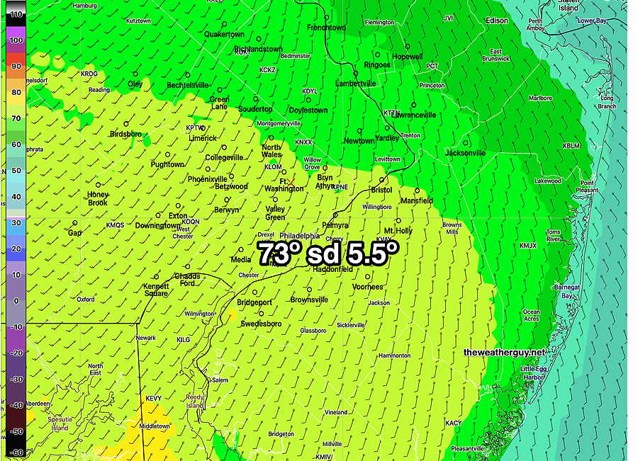
Update Thu 02/23 @ 8:40 AM — The latest 12z NBM captures the trend from last night— most models have trended a bit ‘lower’ for high temperatures today. But there’s still an extremely high spread in model predictions, as shown by a standard deviation (sd) of of almost 5º. This means whatever forecast temp you decide to hang your hat on has high uncertainty in either direction.

As mentioned yesterday, in these situations in the past, I would generally move towards the NBM mean plus the standard deviation, which for Philadelphia would be about 72-73º.

Last night’s ECMWF was in this ballpark. But the very latest HRRR has a high of only 65º for Philadelphia.

NBM high temps, to be reached between 3 and 4 PM. Then temps begin to fall into the 50s by evening—

This morning’s 12z NBM forecast mean max temps for today. Red contours are labeled and are at 2º increments. (Click on image for a larger view.)


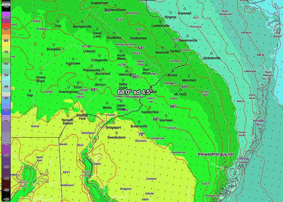
Update Wed 2/22 9:36 PM — Tonight’s early models have the warm front barely making it beyond Philadelphia. High temperatures on Thursday are running a bit ‘cooler’ with expected highs in the mid to upper 60s. Still a large spread in the NBM forecast of almost 7 degrees, so for now, think 67°, as high as 74° or as low as 60°


Previously Posted Wed 5:51 PM —

It’s been well-advertised that we’re going to see some unusually high temperatures on Thursday. What hasn’t been well-advertised is that there is extremely high uncertainty in the model forecast high temperatures.

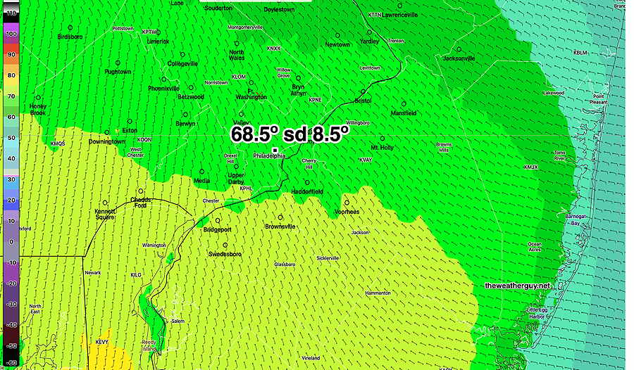
The latest NBM model (which statistically evaluates about 40 different model inputs and compares their forecasts to actual conditions six hours later) shows an extraordinarily high standard deviation (sd) of over 8 degrees.

With an sd of over 8 degrees, a forecast of an average high temperature of 69º means there are models forecasting a high of only 61º and other models forecasting a high of near 77º.

(Typical standard deviations for a next day forecast are about 1.8º, rarely more than 3º.)

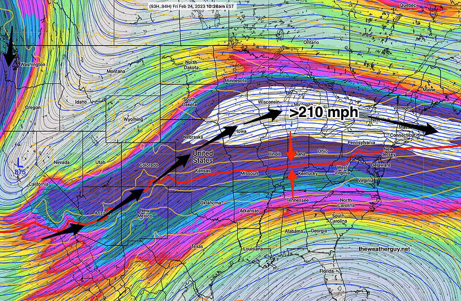
Why? There is a considerable amount of model disagreement regarding how far north the warm front will move.

Here’s the latest Canadian RGEM model, forecasting 75-76º for Center City Philadelphia —

Today’s 18z Canadian RGEM Red ontours are 1º increments You can see what a sharp gradient exists as we get closer to the shore. (Click on image for a larger view.)

(The latest ECMWF is closer to 72º)

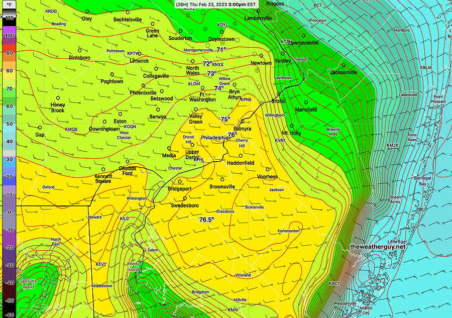
Here’s this afternoon’s NBM model mean forecast high temperatures—

Today’s 19z NBM model forecast max temps (Click on image for a larger view.)

I’m leaning towards the higher Canadian model forecast high temp because many times I’ve seen the NBM undershoot in situations where temps are far from normal.

However, keep in mind, it might just reach 69º or maybe as high as 80º. There will be a tight temperature gradient wherever the warm front stops. Location north to south will be a big factor.

But can we really complain about a high temp of only 68º in February?


THIS WEEK’S WEATHER

#weather #paweather #wx #pawx #philadelphia

Update Tue 2/21 7:10 PM — Looking over some other models suggests the showers on Wednesday are likely, starting between 11 AM and 1 PM. Most interesting is the HRDPS and GEFS which show a chance of the precip starting as snow flurries before changing to rain. I’ll have to see it to believe it.


Previously Posted Tue 5:26 PM —

A cold front has moved through Tuesday afternoon with some showers and gusty winds. Temperatures tonight will drop into the 30s.

The front will return on Wednesday as a warm front.

Wednesday

Several models are forecasting showers late Wednesday morning or early afternoon, although the HRDPS, and to some extent the HRRR, are suggesting the showers fall apart as they move north over Philadelphia. The NBM consensus is that we will have some light showers, but the amounts will be light. (< 0.05″) It will cloudy. High temp Wednesday 43-45º

Thursday

Thursday will start with some low clouds and perhaps fog, but skies will brighten for sunshine. High temperatures between 73º and 78º

Today’s 19z NBM mean high temp forecast for Thursday. sd= standard deviation. An sd of 5.5º is unusually high, indicating high uncertainty and spread among the models that comprise the NBM. (Click on image for a larger view.)

The chance of snow has faded from Saturday’s forecast from most models, except the latest ECMWF, which shows light snow, especially just south of the city, Saturday afternoon.


THIS WEEK’S WEATHER

#weather #paweather #wx #pawx #philadelphia

Tuesday

This week’s weather continues to be defined by a warm — cold boundary that is waving northward and southward of our area while aloft, an extremely fast jet flow in excess of 210 miles/hr generating waves along this boundary.

GFS jet stream level (300 mb) wind speed on Friday. Note the 210 mph jet streak (white area) that remains persistent. (The winds in the jet streak are moving at 210mph… the jet streak area itself (the area of high winds) is hardly moving. A fast changing weather pattern, warm and cold with several impulses of low pressure rain will move through .

We’ll see the these rapid changes tomorrow (Tuesday) and Wednesday and later into at least next week.

Tuesday Forecast– A disturbance moves through after midnight tonight with showers, mostly ending by daybreak Tuesday. A few lingering showers possible Tuesday morning. Periods of clouds and sun Tuesday. Another front moves through Tuesday afternoon (2-4 PM) with a few scattered and locally moderate showers and even a thunderstorm (due to elevated CAPE in the 400 Joules/Kg range. )

Windy with the frontal passage. Skies clear in the later Tuesday afternoon. High Temps 54º-56º

A warm front moves through Wednesday afternoon with showers and possibly thundershowers.