Category Archives: Philadelphia Area Weather Forecasts

Philly Weekend Weather Forecast


Low pressure approaching from the Mississippi Valley will bring rain to our area on Saturday.  Rain will start before midnight and imagewill be heavy before daybreak and during the morning on Saturday.  Rain tapers to showers after 2 PM and ends about 5 PM.  QPF values about 0.75 inches. High temperature about 53.
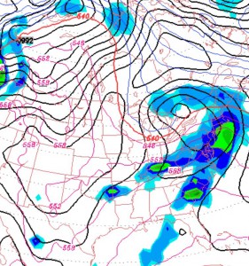
The low pressure system responsible for the rain Saturday will be slow to exit the NE and on Sunday, we’ll be influenced by a cyclonic flow around that low.   Windy conditions will make the temps in the upper 40s seem colder.   A mix of  considerable instability clouds and sunshine.  A typical March day.

Update 9:30 pm – latest models have close to an inch of rain, lasting into the early evening Saturday.


Philly Weekend Weather Forecast

High pressure builds in for this weekend. Continued below average temperatures, although it might feel relatively warm.

A weak upper air disturbance comes through late Saturday afternoon.  Sunny in the morning,  but increasing cloudiness expected Saturday afternoon.  High 37.

Updated Saturday @ 4 PM:

High pressure again for Sunday.  Mostly sunny,  Considerable cloudiness, some breaks of sun mid- day.  High 45.

(Average high temperature for PHL this week in March is 51!)

Philly Winter Weather Update

The latest models continue the trend towards somewhat lower QPF values during the period when thermal profiles support snow.  Latest NAM is about 0.40 inches water for Philadelphia during the period from 7 AM to 7PM.   This afternoon’s GFS had very similar amounts. This translates into about 4-7 inches of snow.

Most of the heavier precipitation will occur with the actual frontal passage, however temperatures at the surface and aloft will not support snow during that earlier time frame, so much of the heavier precipitation will be sleet, then wet snow.

Still many factors that make this sort of precipitation event difficult to nail down accurately. It’s not really a “storm” or defined low pressure system in the usual sense.  Instead it’s moisture spilling over a stalled frontal boundary.  Aside from all the temperature unknowns, I don’t think the models are all that good at predicting the QPF in this situation.   However, they have been somewhat consistent about the timing and other aspects. I guess we’ll see.

Roadways may not accumulate as much snow as grassy surfaces during the day tomorrow.  Sleet and ice will comprise the bottom layer of this snowfall, making cleanup a bit of challenge later Thursday.

Tonight’s  NAM data will be available about 9:15 PM and the GFS data about 10:40 PM.  So I’ll update about 10: 50 PM.