Category Archives: Philadelphia Area Weather Forecasts

Will it rain on the 4th in Philly?

The short answer is “probably possibly yes”.

This morning’s NAM and GFS models had a wide difference of opinions, with the NAM shearing the low pressure system with only a 35% chance of rain and the GFS had a more developed low with an 85% chance of rain. (The last time I saw this divergence, we had that “fizzled” snowstorm in February that made the weathercasters look bad.)

This afternoon’s run of the NAM has returned to a rainier scenario. So Saturday looks cloudy with showers likely in the morning and mid-day.   Temps will be cool , in the low 70s. The positive view is that any rain we get will likely be over in the early evening, in time for the fireworks.

With  the divergence in model solutions, there is below average confidence in this forecast.

Updated 7 PM:  The amount of precipitation predicted by the afternoon models continues to decrease around PHL.  Any showers will likely end by mid afternoon.   Still a low confidence situation.

Updated 10:30 PM: Tonight’s NAM still cranks out rain for Saturday, ending mid to late afternoon.

Philly Weekend Weather Forecast

The forecast remains essentially unchanged.  Low pressure and an easterly flow will bring rain for much of Saturday.  Rain will begin by mid to late Saturday morning  and become heavier into the afternoon and evening. There’s a chance of embedded thunderstorms late afternoon.  Windy with temperatures near 70.  The latest models have backed away from the multiple inches of rain here, but locally heavy rain with convective thunderstorms is possible.

For Sunday, the rain ends before daybreak , but a cyclonic flow will keep the skies from fully clearing.  So a mix of sun and clouds with temperatures near 80.

Philly Weekend Weekend Weather Update

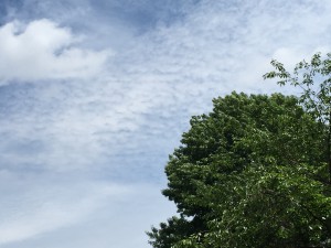
Advancing moisture aloft with cirrocumulus undulatus

Latest NAM and GFS models similar in having the remnants of what was tropical storm Bill move directly over our area for Saturday night into Sunday morning.  Both models crank out about 2 inches of rain with the heavy rain falling after midnight Saturday into daybreak Sunday.

It’s not surprising that the NWS issued a flash flood watch for this time period.

It appears that Saturday will start dry, but showers and thunderstorms develop late afternoon and become progressively heavier during Saturday night.

See my earlier forecast for other details.