Why is it raining now at 10AM? I thought it was going to start in the afternoon?
That’s a great question. I have no answer.
Every model from last night (RAP, HRRR, NAM, HIRESW, NAM-NEST, GFS, etc) had the rain starting about 1-3 PM. Even more incredible is that the new models from this morning 12z (8AM EDT) were still holding off the showers until the afternoon here.
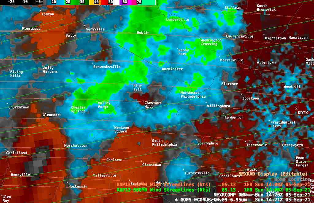
Current Radar 10:20 AM EDT—
NEXRAD radar with Satellite Water Vapor superimposed. (Click on image for a larger view.)
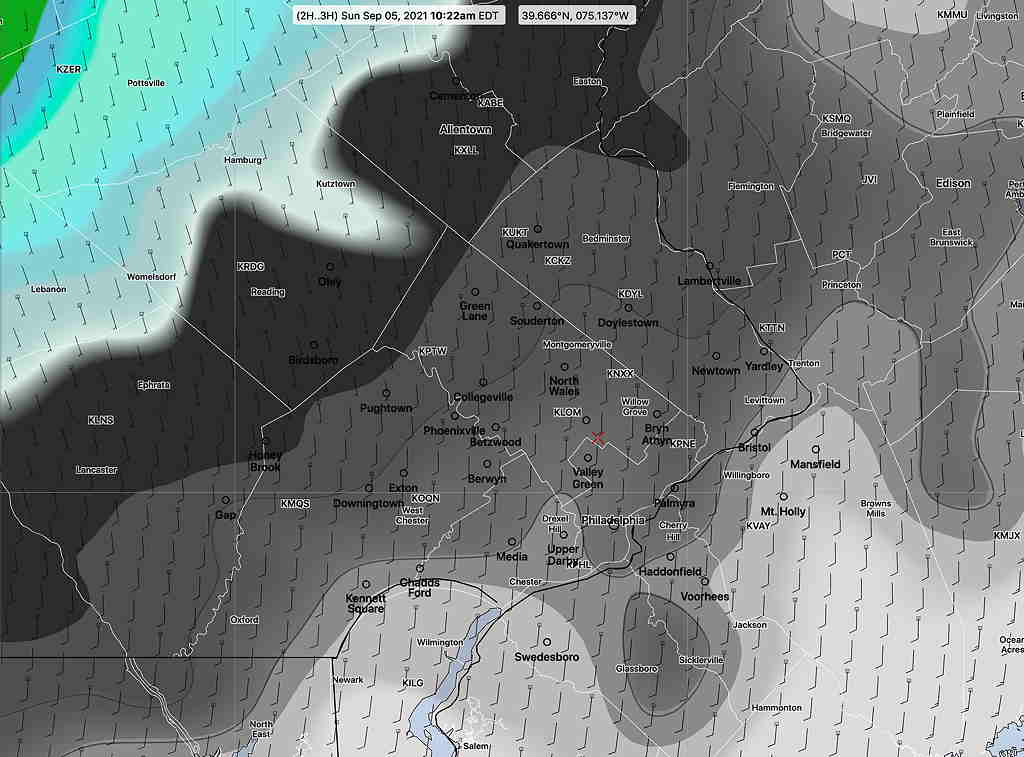
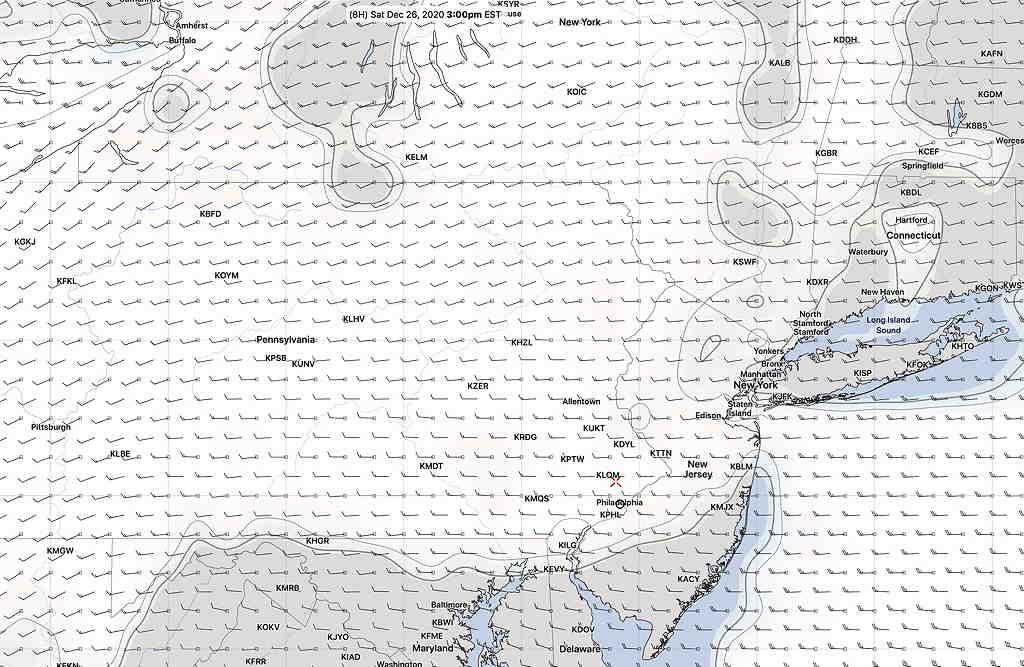
Here’s the latest NAM model which is representative of all the NOAA and Canadian model forecasts for today—
This morning’s NAM model forecast for 10 AM, still showing the showers about 2 hours to our west. This model, which was run only two hours ago, was representative of all the US models from this morning and last night. (Click on image for a larger view.)
Interestingly, I took a look at the 2 AM German ICON model forecast for this morning. Not a bad forecast ! Would I have used its forecast instead of all the NOAA models. Not likely—
ICON model 06z rain and cloud forecast for 10 AM today. Clearly it did something right. (Click on image for a larger view.)
The National Weather Service/NOAA creates a weather prediction model that is a statistical composite of many different models— it’s called the “NBM” or “National Blend of Models”. The NBM is created and updated hourly by NOAA and is the product of about 8-9 years of development. It’s current version, 4.0, became operational this past December 2020.
The NBM is a sophisticated and advanced attempt to combine the best forecasts of numerous weather models including multiple U.S. short/long range/ensemble models, several Canadian models/ensemble models and the European model/ensemble models. It also combines various “model output statistics” (“MOS”) and hourly “LAMP” forecasts.
It attempts to achieve its aim by re-examining the forecasts of the models hourly and comparing those forecasts to actual measurements adjusted to actual measured conditions six hours earlier. From the comparisons to actual conditions, it statistically weights the forecast going forward to the best performing model(s) six hours earlier.
The NBM ingests different model runs and forecast statistics at scheduled times during the day and creates a variety of forecast products, including maximum/minimum forecast temperatures and precipitation forecasts.
The NBM is the model I’ve been using for my high temperature forecasts.
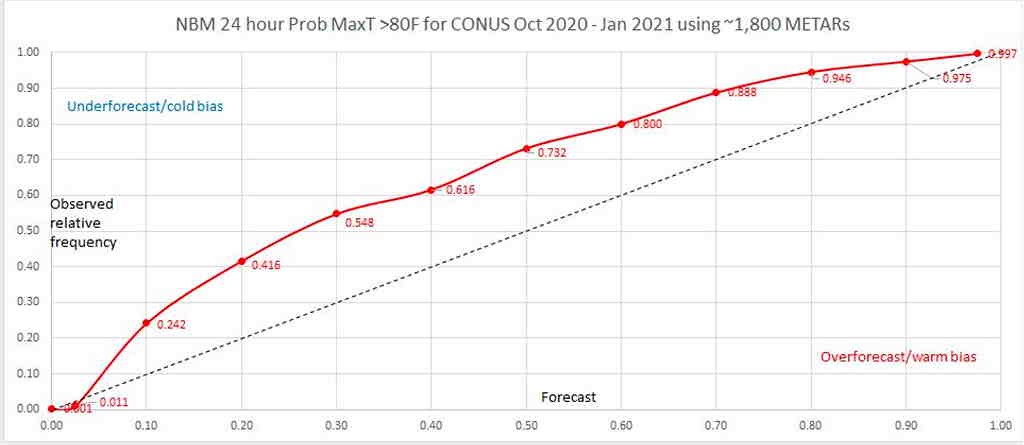
I’ve noticed something for awhile, recently confirmed today by an official notice. The NBM high temperature forecasts (“TMAX”) are too low, and the error is higher with higher expected TMAX temperatures.
(I’ve been including the “sd”(standard deviation) in my forecasts for months. I’ve noticed that the actual TMAX is often a degree or so higher than the NBM predicted value PLUS its standard deviation.)
Today, the NBM predicted TMAX for Blue Bell was 49º with an sd of 4.4º The actual TMAX was 53º.
So the actual TMAX was = TMAX + sd!
The NOAA statistical modeling group today released a report today. This graphic captures the problem of the cold bias in the NBM max temp forecasts.
NBM TMAX Bias (Click on image for a larger view.)
With this disclosure, I’ll be getting rid of my inclusion of the standard deviation in my forecasts (as had been my practice these past six months) and instead will simply be adding the sd to the forecast high temp going forward…and hoping for the best.
With the recent disclosure that the precipitation statistics are also biased too low, we can hope for an early release of NBM version 4.1 or NBM v.5. (Actually, the precipitation problem is being addressed with an update in March.)
The main model used in US weather forecasting is the GFS (Global Forecast System), a model that continues to be developed and improved. The last major upgrade to the GFS model occurred in June 2019 with the release of the GFS-FV3 which was “version 15” in its evolution.
I wrote a brief post about this model back then, describing the changes in “FV3” ( Finite-Volume Cubed Sphere Dynamical Core) geometry that the model uses to divide up the atmosphere into geometric units that can be handled mathematically. The complexity of these models is amazing and the NOAA scientists that create these models can only be admired.
The new version of the GFS model continues with the FV3 geometry (in the long line of this model evolution, this will be GFS version 16) and it has just become available this past week on a full time NOAA server. It’s available in what is referred to as a test “parallel mode”, meaning that it is running at the same time the current operational version (v 15) is running.
If you’re into technical stuff, or just want to be dazzled by the science of these models, check out this early presentation from the NOAA Model Evaluation Group. It gives a brief history of the GFS model development and also presents the improvements, short-comings and challenges of the new GFS v16 model. The official GFS v16 evaluation website can be found here with plenty of additional information.
If all goes according to plan, it should become the GFS model early February 2021.
I would expect general improvements in weather forecasts with its release. Additionally, the GFS model is used to set the boundaries and initial conditions for several other models—
So several other models’ accuracy will benefit when the GFS v16 becomes operational early 2021.
What could be a better example of the new GFS model’s improvement than today’s cloud forecast? Last night’s operational GFS had forecast for it to be sunny here at 3 PM today, keeping the clouds to our west —
Current GFS model showing clouds stay to our west at 3 PM (Click on image for a larger view.)
The new, soon to become operational GFS version 16, had a correct cloud forecast for today at 3PM—
New GFS (version 16) had the correct cloud forecast for this afternoon, showing clouds overspread much of the area. (Click on image for a larger view.)
Last night’s indecision about cloud cover for today would have been less of a dilemma had I used the new GFS.
One of the issues of the new GFS is that the new model’s data size is almost twice as large as the existing GFS. NOAA is concerned about the data download size issue and it is expected to limit data download rates within the month for all their models. We’ll see how that plays out.
Another minor issue— the higher complexity of the new GFS takes more computational time. As a result, the new model take 7-12 minutes longer to complete. As an example, the first 24 hours of the current GFS become available about 10:37 PM EST. With the new GFS model, the first 24 hour forecast data will become available about 10:46 PM EST.
Those 11 PM TV weather entertainers are going to have even less time to update their forecasts during Eastern Standard Time.
The new model is an overall improvement, but not without its problems. It tends to handle tropical systems not so well, sometimes developing systems that don’t actually form. Certain parameters used for forecasting thunderstorms are understated, especially when soil moisture is low. Forecast temperature biases, while improved, also have their issues. You can be sure that scientists are already hard at work with a future version 17.
One more thing— the HRRR and RAP models were updated earlier this month and have shown improved forecasting accuracy and an increase in model forecast length. The HRRR has become a full 48 hour model and the RAP a 51 hour model. These same models are expected to start using the same FV3 core geometry used by the GFS in their own next iterations.
Several other high resolution models (HIRESW and HIREF) have been upgraded to the FV3 core geometry and are planned for release in the next few months. Their output is now available as “parallel” models.