
The models have been advertising another coastal snow storm development for Tuesday night into Wednesday. Not all of the major models are totally on-board with this scenario, but it still appears more than likely. The wind intensity of this storm will NOT be anything like this past Friday, although snowfall rates may look impressive during the day.
Incredibly, the current range is anywhere from 6-10 inches of snow for Philadelphia , based on the GFS (6″) and the NAM (10″).
Current timing- light snow develops during the evening Tuesday and increases in intensity after daybreak Wednesday, as the secondary coastal low develops and intensifies.
There’s still some thought that warm air might mix in, but right now the NAM and GFS critical temperatures all support snow.
I’ve given much thought about this past storm I’m not going to get into the March sun angle, solar insolation and ground temperature effects, since it made giving an accurate accumulation forecast impossible. I guess in March, it’s really about snowfall rate, not accumulation since accumulations mean much less in March— the snow can start melting as soon as it falls.
I’ll keep an eye on this one and will update tomorrow!
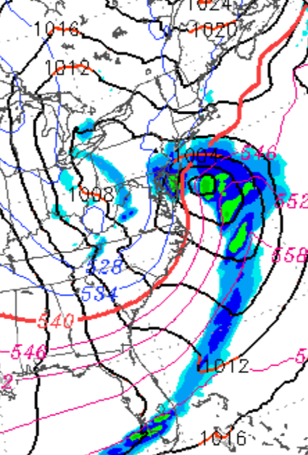
[su_note note_color=”#ebf2d9″]Sunday 10pm: The latest NAM data shows a significant snowstorm for Philadelphia on Wednesday. QPF values are almost two inches water. Critical temperatures show it falling as heavy wet snow. Still too early to be sure, but this could be a major snowfall.
11pm: Tonight’s GFS confirms a major snowstorm likely for PHL. We’ll be waking up to heavy snow falling on Wednesday, snowfall increases for the rest of the day. Current models suggest as much as 15 inches! Too soon to hang our hat on this.
[/su_note]