
#Philadelphia #weather #PAwx
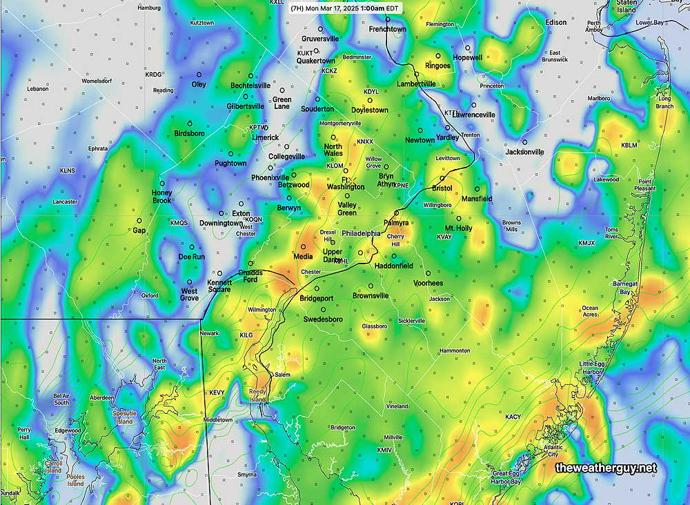
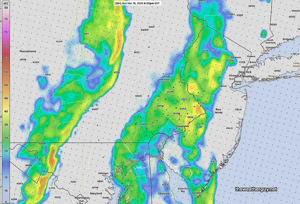
Posted Sunday 03/16/25 @ 7:51 PM — Based on the latest HRRR, the showers and storms arrive in the immediate Philadelphia area between 11:30 PM and 1 AM. The HRRR shows the rain area to “blossom” as the two separate lines merge.
So far, not much has played out as forecast yesterday and this morning. Two bands of precipitation have formed, as forecast, but the first prefrontal band has not had the heavy rain/thunderstorms as forecast.
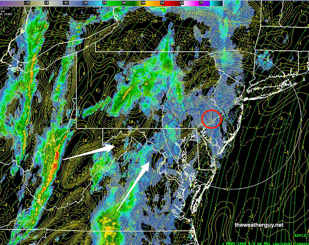
Here are the two bands at 5 PM—
This afternoon’s 18z HRRR is still forecasting heavy rain from the city eastward. I guess we’ll see.
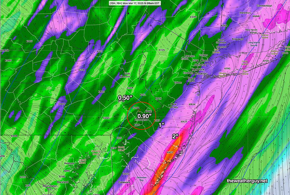
The ECMWF-AI model forecast still has heavy rain of over 1″, but the rain occurs later tonight into Monday due to a second low pressure system forecast to develop.
Sunday Forecast Update
Posted Sunday 03/16/25 @ 11:09 AM — Here are the trends I’m seeing with the approaching storm system and cold front—
- The approaching system has slowed. Rain and thunderstorms are now forecast to enter the western Chester/Montco/Bucks counties between 2 and 4 PM.
- Multiple Low pressure systems will form along this approaching front. Based on the several runs of the ECMWF-AI-Single, rain and showers will extend into Monday morning and possibly longer at the shore.
- This morning’s HRRR shows a significant increase in CAPE, the thermal energy ingredient that was missing from the model forecasts yesterday. With CAPE increasing to be over 300 joules/kg in western suburbs, the risk of stronger thunderstorms is increased. (CAPE at 300 is still low by mid-summer storm standards, but enough to put more severe weather into play.)
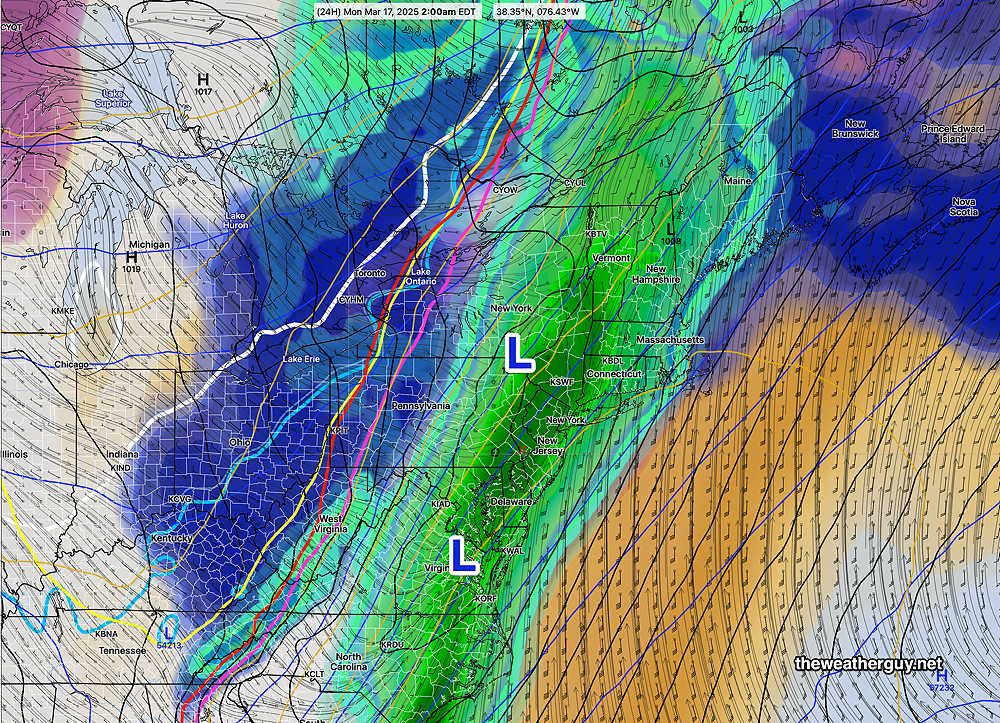
- Here’s the latest ECMWF-AI-Single forecast for 2 AM—
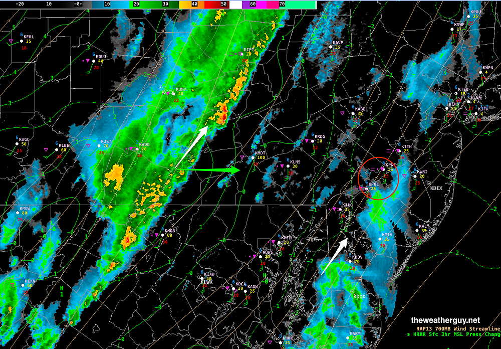
Here’s the current MRMS radar. Areas of storms and upward vertical motion to our southwest and west will approach our area—
Sunday Forecast Update
Posted Saturday 03/15/25 @ 5:34 PM — As expected, some elements of the earlier model’s forecast have changed. Here’s the current thinking, based on the latest HRRR and ECMWF-AI-Single models—
- Some light showers, mostly far western suburbs possible in the late morning Sunday.
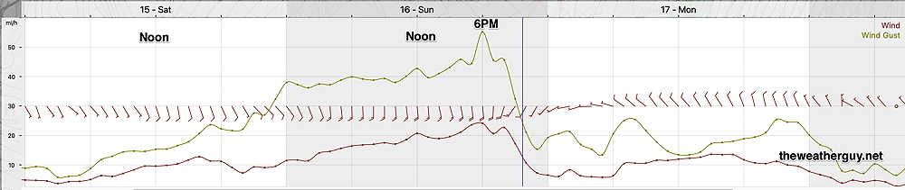
- Wind gusts increase to near 40 mph around noon.
- Showers and thunderstorms develop between 12 PM and 2 PM just west of Philadelphia.
- Rain becomes increasingly heavy by 4 PM -5 PM from the city westward.
- Wind gusts near 50 mph around 4 PM -5 PM in the city.
- Showers and storms continue into the evening beyond midnight.
- Heavy activity at the Jersey shore about 11 PM – 2 AM
The high resolution HRRR shows the rain approaching as two lines/areas—
Many areas will see the possibility of damaging high winds and heavy rainfall. Here’s a simulated radar sequence with helicity, as forecast by the HRRR—

As mentioned earlier, high helicity values with high wind shear can create tornadoes, although thermal energy in the form of CAPE is absent tomorrow. Areas to our west and to our north may see the most severe weather, although even the Jersey shore may see some severe weather.
Saturday Update and Sunday’s Potential Severe Weather
Posted Saturday 03/15/25 @ 9:18 AM — The fog, low clouds and drizzle are here and we’ll be locked in to this for much of the day. The models that had some clearing later this afternoon was based on their forecast for a warm front to move north of our area.
There are still models that show this, but the latest AI model (ECMWF-AI-Single) keeps the warm front to our south and the cloudiness persistent.
(This is the reason yesterday’s AI model had only forecast a high today of 52º, in contrast to the NBM which was forecasting a highs in the low 60s.)
Turning to Sunday…
The potential for severe weather on Sunday has been well-advertised. The latest HRRR supports the likelihood of severe weather, including tornadic activity. The most likely timing is between 5 PM and 11 PM Sunday evening. Wind gusts 50-60 mph area forecast.
In reviewing the 06z HRRR, two potential severe parameters stuck out—
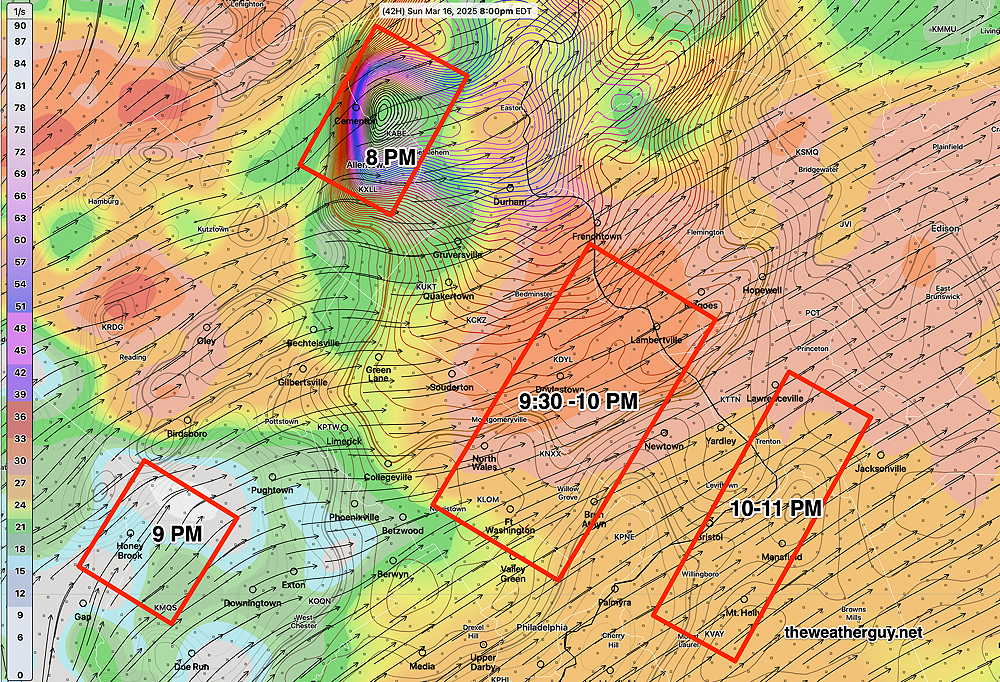
The area near Allentown is showing extreme helicity values in the 1150 m2/s2 range. In our area, helicity greater than 1000 often results in some tornadic activity. A missing ingredient is high CAPE (thermal instability energy), but the high wind shear and extreme helicity values can compensate for that missing thermal energy source.
This forecast is 40+ hours in the future. Expect the areas highlighted above to change over the next 30 hours.
Saturday Forecast Update
Posted Friday 03/14/25 @ 9:29 PM — With Daylight Saving Time in effect, the models are available an hour later. My usual posting time for the Weekend Weather Forecast, between 5 PM and 6 PM, missed several models.
There are some changes in the forecast that have come to light with the these afternoon models. In addition to low clouds for Saturday morning, it appears that fog and even some light drizzle may develop early Saturday morning, according to the several models. This will be especially true along the Jersey Shore. Fog dissipates towards noon. We may see some brightening of the skies in the afternoon on Saturday.
Here’s tonight’s 00z NBM showing visibility less than 1/2 mile for much of the region at 10 AM—

Previously Posted Fri @ 4:10 PM — —Deep low pressure will move up through the Great Lakes this weekend as additional lows develop along and ahead of a cold front.

Clouds ahead of this system will be with us on Saturday.
Some showers are possible as early as late Sunday morning, especially west of the city. Strong winds, wind shear and high gusts may result in downed trees. Rainfall will be heavy with the heaviest occurring during Sunday evening into the after midnight hours. Rainfall about 1.1″
A brief dip in the jet will allow cold air Monday into early Tuesday. Temperatures rebound quickly though next week.
Saturday Forecast
Low clouds for much of the day. Mild. There may be some breaks in the cloudiness late afternoon into the evening.
NBM high temperatures: Blue Bell, PA 60º Philadelphia, PA 62º
High Uncertainty (based on standard deviation): ± 4.2º
AI model high temperatures are about 10 degrees lower ~52º!
Sunday Forecast
Cloudy with showers west of the city by late morning. Showers, thunderstorms and high wind gusts in the afternoon into the evening and past midnight. Wind gusts near 50 mph possible. Rainfall 1.1″
NBM high temperatures: Blue Bell, PA 67º Philadelphia, PA 68º
Average uncertainty (based on standard deviation): ± 2.4º