The latest NAM model data becoming available at this time. (When in Eastern Standard Time, some data is available as early as 9:10, but with Daylight Savings Time, all models are available an hour later local time.).
The latest NAM data shows snow for our area, but again with a fast cut off north and west of PHL. Latest QPF values are in line with last night’s GFS- about 0.21 inches water, mostly falling during the evening hours. 1-2 inches in PHL possible, mostly on grassy surfaces, more in areas of NJ. Snow starts late this afternoon here in PHL and goes through a little after midnight. (Much earlier in Delaware where they may have a more significant accumulation. )
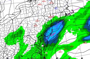
Here’s the NAM forecast map for the 3 hour period prior to 10 PM tonight

Notice how the bullseye for the snow is just east of PHL. Small variations can again blow this forecast.
1PM Update- This morning’s GFS has the precipitation further east and barely reaches PHL. So this could be another zero.
8PM Update- There is some snow falling, but surface temperatures in the region just seem too warm for any accumulation. .

Thanks for the great updates. Very much appreciated!!!
Glad they’re helpful. I enjoy this hobby. Wouldn’t want to do this full time, though. 🙂