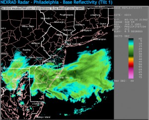
The heaviest precipitation was expected to be just south of PHL and the precipitation cut off north of PHL is sharper than I would have guessed today.
(I use KPHL, the gridpoint for Philadelphia airport for my data. Several data packages, especially the NAM FOUS are specific for this grid point. It usually serves me well, but not with a sharp cutoff like today.)
So, I’ve been waiting for something to fall from the sky today and here in the northwest part of city, we’ve had nadda. But radar shows precipitation just south of the city.

The latest NAM data (for KPHL) has gone back to a low QPF, about 0.11. If we’re going to see anything, it would be between now and 9 PM.
