#Philadelphia #weather #PAwx #PhillyWx
Active Weather Wednesday
Posted Tuesday 08/12/25 @ 8:02 PM — An upper level short wave will move through during the afternoon and evening hours on Wednesday.
An increase in humidity Tuesday night will result in fog Wednesday morning. There may even be some light patchy drizzle in some areas around daybreak.
Clouds should break late morning for hazy sunshine through a layer of high cirrus clouds. With daytime heating and the moisture in place, the approaching shortwave will result in showers and thunderstorms as early as 2-4 PM. These will be scattered and it won’t be possible to pinpoint the exact locations in advance. Showers and storms will become more numerous by early evening. Some of these storms will likely result in pockets of heavy rain.
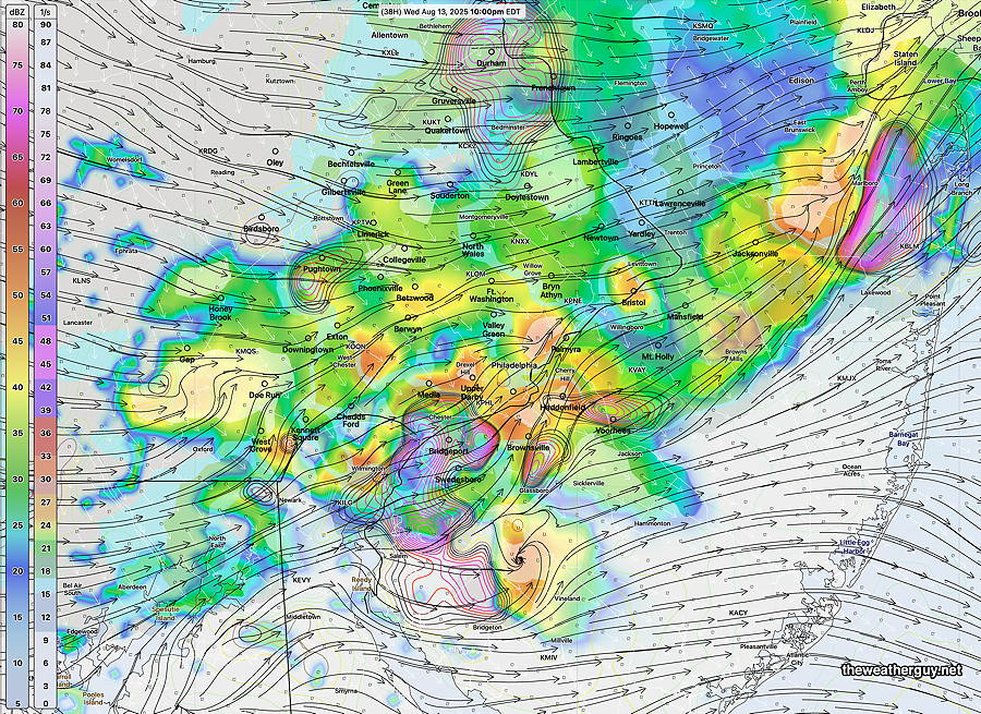
The Canadian RGEM and the RRFS along with the HRRR are forecasting areas of unusually heavy rainfall ( 3.7″) with storms right around the immediate Philadelphia area through much of the evening. Some strong dynamics move through about 9 -10 PM with possible severe weather.
The RRFS forecast at 10 PM—
We’ll have a better handle on severity aspects Wednesday morning. I’ll update after 8:45AM with the new data.
Monday Update
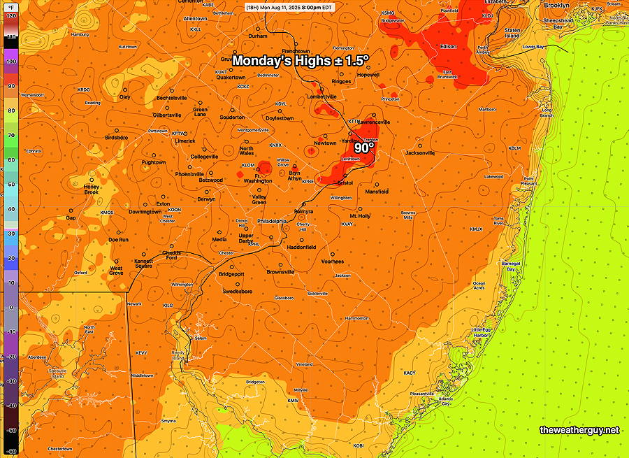
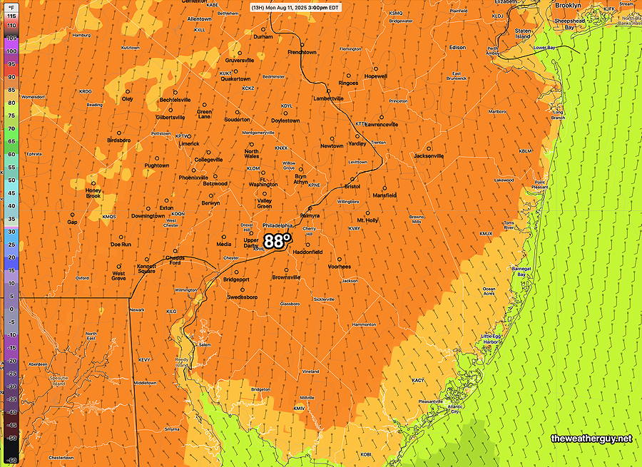
Posted Monday 08/11/25 @ 9:20 AM — I’ve been hearing much about temperatures reaching 90º here today. That certainly may happen, but most models have us in the upper 80s, with only a small area reaching 90º. Add the low humidity and the apparent temperature (heat index) will be in the upper 80s just about everywhere.
Factor in the low humidity, and the apparent temperature is only in the upper 80s—
Tuesday will likely reach 90º in more areas. Wednesday‘s high temps may be damped down to the low 90s due to cloud cover, but Wednesday’s humidity will be noticeable with the heat index in the mid 90s.
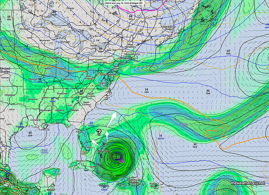
Regarding the likely western Atlantic hurricane next week, it appears it will be blocked from moving westward. Current AI model tracks suggest a movement to the north, then northeast away from the coast.
Originally Posted Sun 9:52 PM —An increase in heat and humidity will be in store for the Philadelphia area this coming week, especially noticeable Tuesday and Wednesday. An approaching cold front will bring some showers and storms sometime late Wednesday afternoon or evening. Temperatures in the 90s will be widespread by Tuesday and Wednesday, with heat indices significantly higher.
The new dry period we’ve recently entered may not be broken by the showers late Wednesday, as most of the shower/storms are currently forecast to stay to our north and west. That may change, especially since the front may linger nearby on Thursday.
Long time followers of this blog know that I’ve seen a relationship between hurricane development near the continental US and model forecast accuracy of seemingly unrelated weather far from the storm.
This may become a factor as we approach the weekend and beyond. A tropical system, likely a hurricane will approach the southeastern US. Track of the storm is uncertain, but the European AI model was outstanding last year. It currently is forecasting a hurricane (AL97) approaching Florida or South Carolina by next Monday evening or Tuesday.
Many models are forecasting this storm’s formation and there’s disagreement in the eventual track, even between the current GFS-AI and ECMWF-AI models. Here’s the ECMWF-AI—