
#Philadelphia #weather #PAwx
Posted Sunday 02/16/25 @ 8:56 PM —The well-advertised storm expected for Wednesday into Thursday looks to only brush the Philadelphia area with possibly 1-2 inches of snow. Areas near the Jersey shore may see substantial snow, based on the current track. Updates tomorrow!
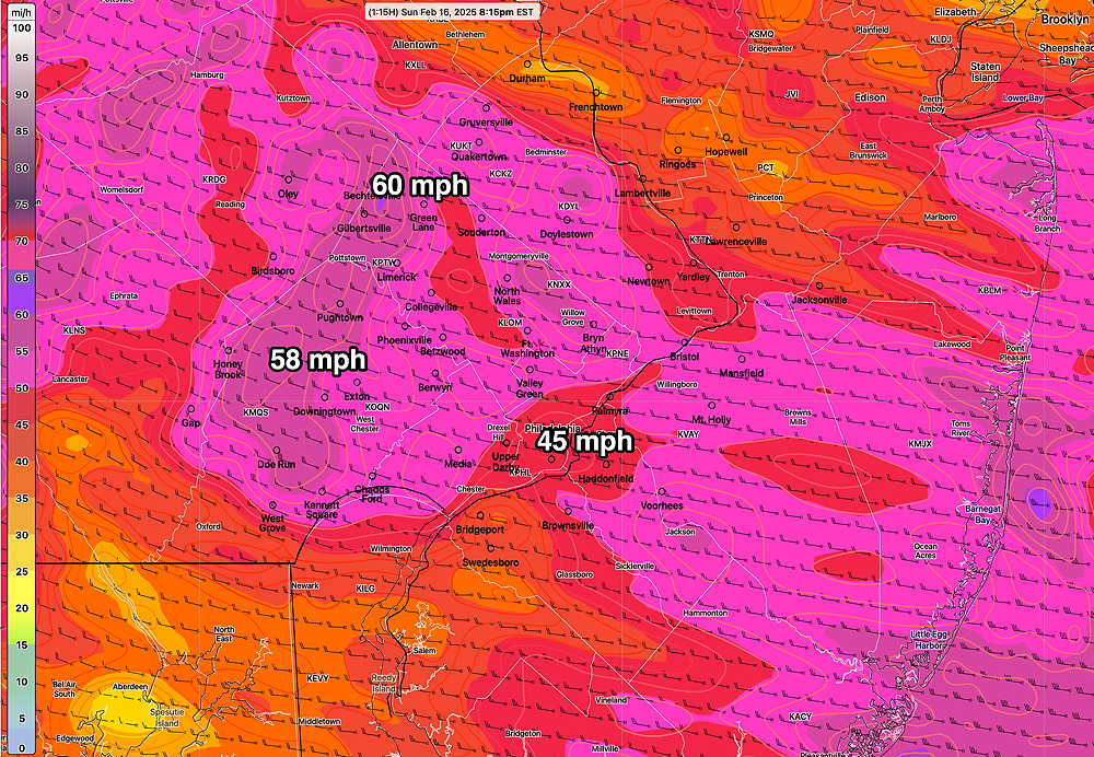
The RTMA is a real-time data model run every 15 minutes, reporting for the previous 15 minutes. Here’s the wind gusts it’s showing at 8:15 PM—
Sunday Forecast Update
Posted Sunday 02/16/25 @ 2:35 PM — Based on the latest radar, satellite and HRRR hourly data, it doesn’t appear that we’ll see those near 60º temperatures forecast by the models yesterday. (Some areas in South Jersey may see those highs about 3-4 PM)
The cold front is in central PA at this time. Some additional showers may accompany the actual frontal passage around 3:30 PM-5 PM.

Sunday Forecast Update
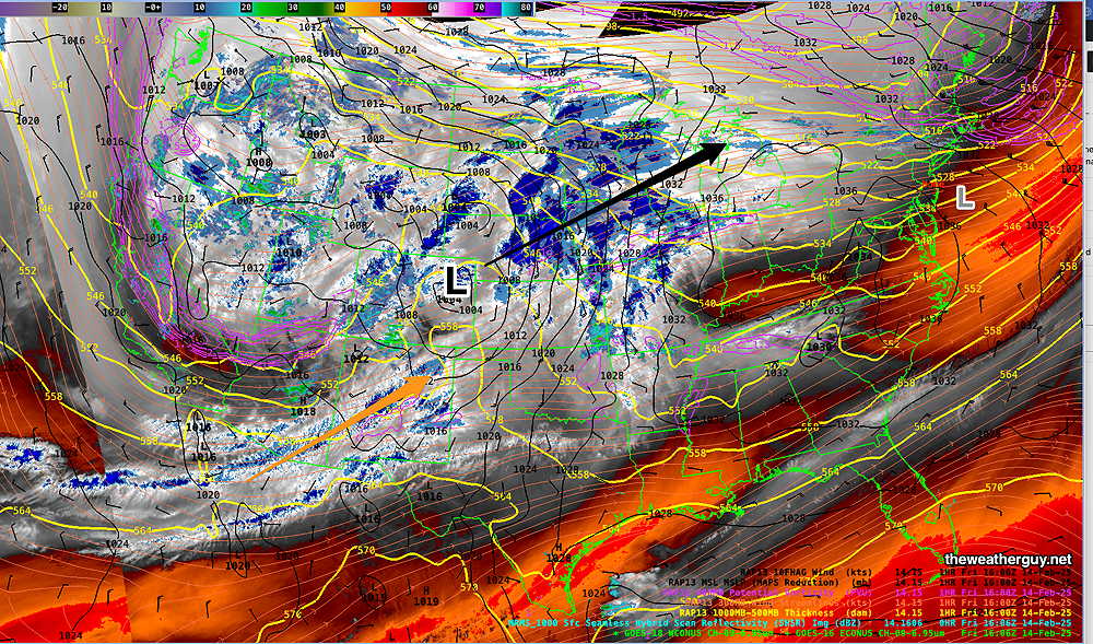
Posted Sunday 02/16/25 @ 9:23 AM — The latest NBM and HRRR show the heaviest rain to occur here between 12 PM and 3 PM. Here’s the latest HRRR—
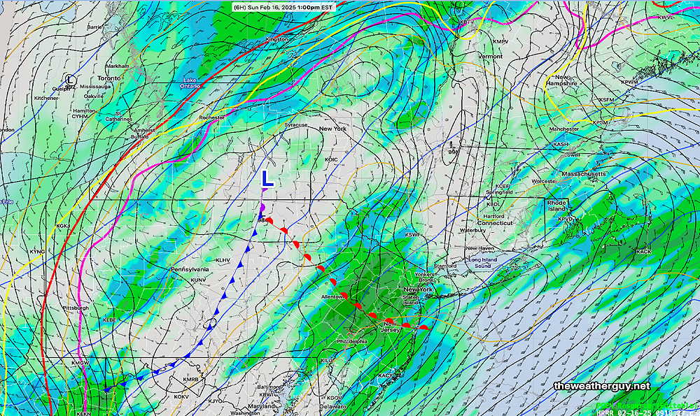
Total additional rainfall about 0.45- 0.65″ Wind gusts as high as 40-50 mph between 3 PM and 6 PM and continuing gusty. Rain tapers off and ends about 5- 6 PM or so.
I’m keeping an eye on the potential storm late Wednesday into Thursday. It still appears to have a track too far south for heavy snow here, according the the AI models. Still much uncertainty.
Due to the highly unbalanced political environment on X, I’ve considerably cut back auto-posting there. To receive all forecast postings, I recommend following me on mastodon.social or bluesky.social
Forecast Update
Posted Saturday 02/15/25 @ 9:32 PM — Tonight’s models show some changes in the Sunday forecast—
- Total rainfall will be closer to 1 inch or less instead of 1-2 inches.
- Winds will increase significantly during the afternoon and evening.
- The most likely time for thunder is about 2-3 PM.
- The heaviest rain will fall 1 PM to 3 PM.
- Rain ends by 4:30-6 PM.
Active Weather Pattern
Posted Saturday 02/15/25 @ 5:38 PM — The heaviest rain will be arriving after 9 PM tonight and continue through the night. There may be a break in the rain Sunday morning (8 AM- Noon), following the passage of the warm front. Rain returns by the early afternoon and continues ahead the approaching cold front.
Expect some thunderstorms and very gusty winds in excess of 40 mph. ahead of the cold front on Sunday. The cold front moves through between 4 and 6 PM. Total rainfall for this storm is still expected to be in the 1.5″ range.
Very cold weather returns for next week, as the storm track moves to our south.
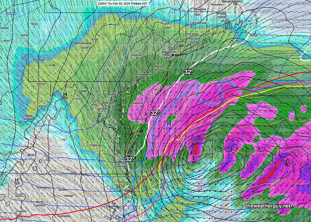
A possible significant snow storm for us is forecast for late Wednesday into Thursday.
While the AI models are suggesting much of the snow might miss the Philadelphia area, mostly affecting South Jersey, However the operational models (GFS, ECMWF, Canadian GEM) are forecasting a potential 6+” snowfall for us. Too soon to hang your hat on this forecast.
Here’s the ECMWF for next Thursday—
Snow and Rain on the Way
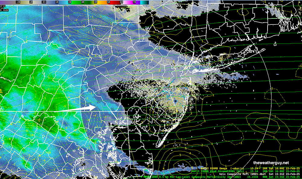
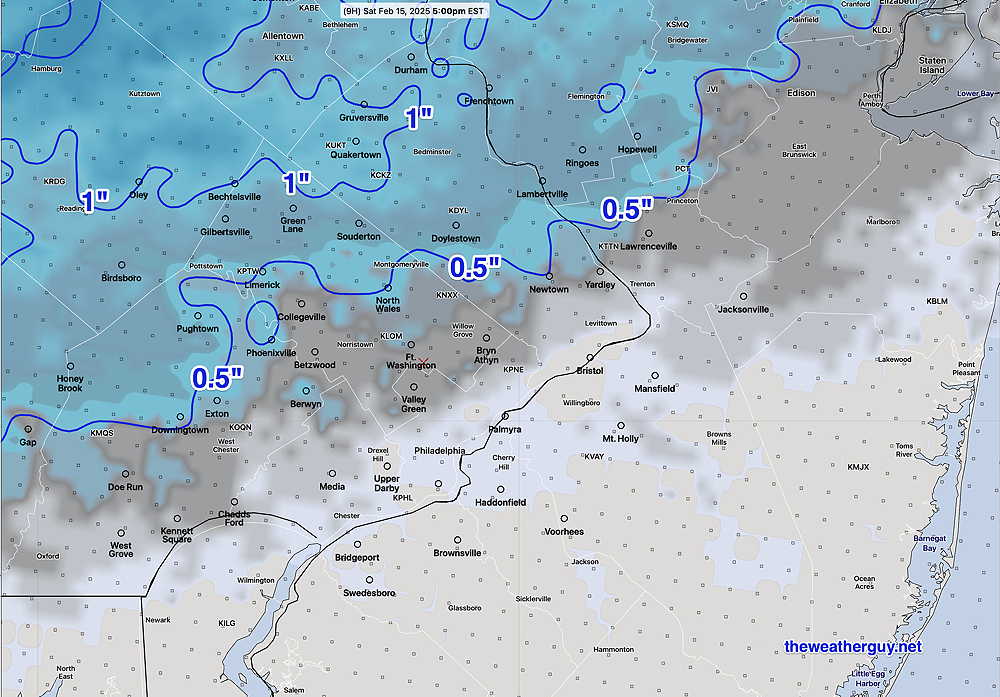
Posted Saturday 02/15/25 @ 10:27 AM —The models, not unexpectedly, are leaning towards less snow/sleet accumulation. The precip is on our doorstep, but a dry lower atmosphere will maintain the 12 PM – 2 PM start time
Here’s the latest NBM snow/sleet accumulation—
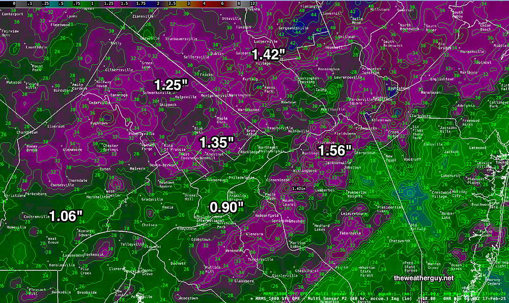
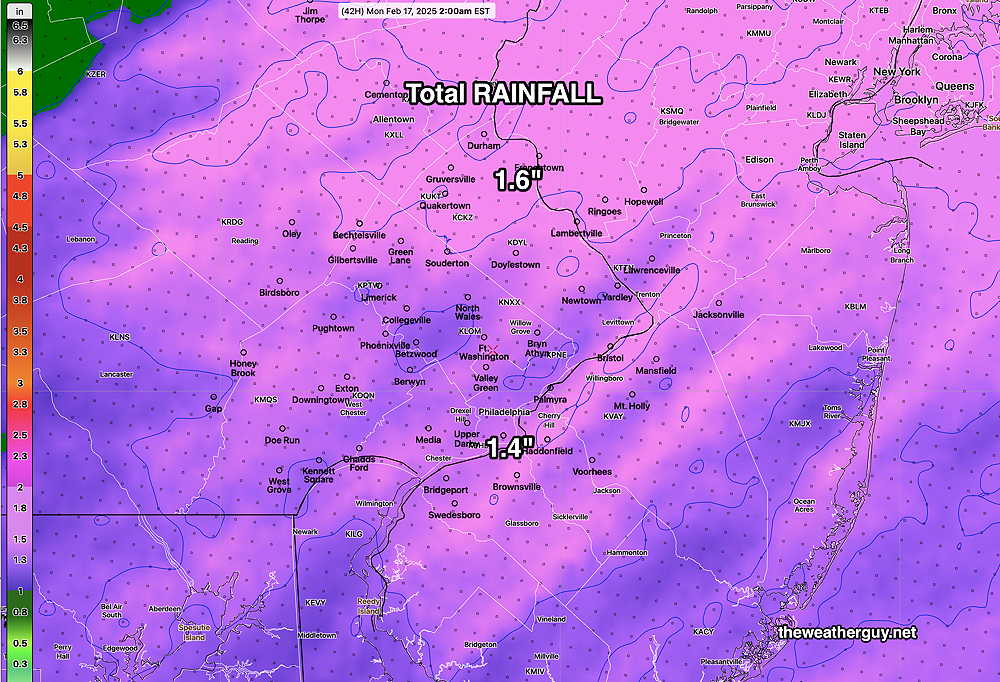
Total rainfall for the weekend will be about 1.3″-1.5, although some models have close to 2+” in some areas.
Starting as Snow
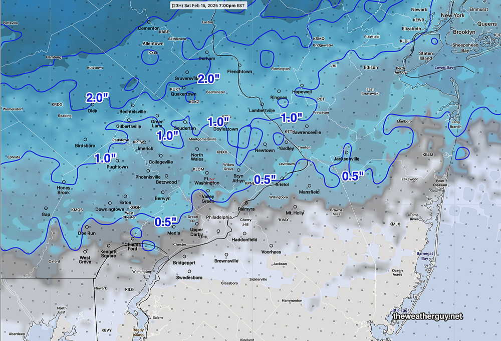
Posted Friday 02/14/25 @ 9:39 PM — More models have a forecast of snow accumulation prior to a changeover to rain late afternoon Saturday or Saturday early evening.
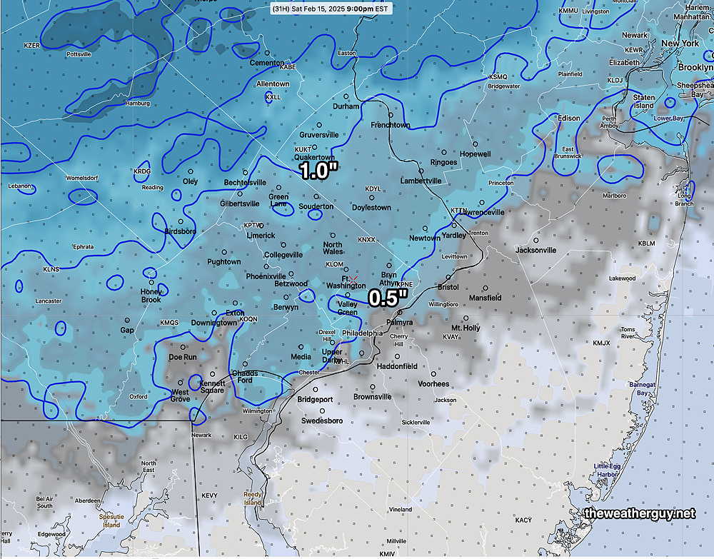
The latest HRRR has minimal snow accumulation. The model blend (NBM) is still cranking out accumulating snow, despite temperatures rising above freezing near the surface.
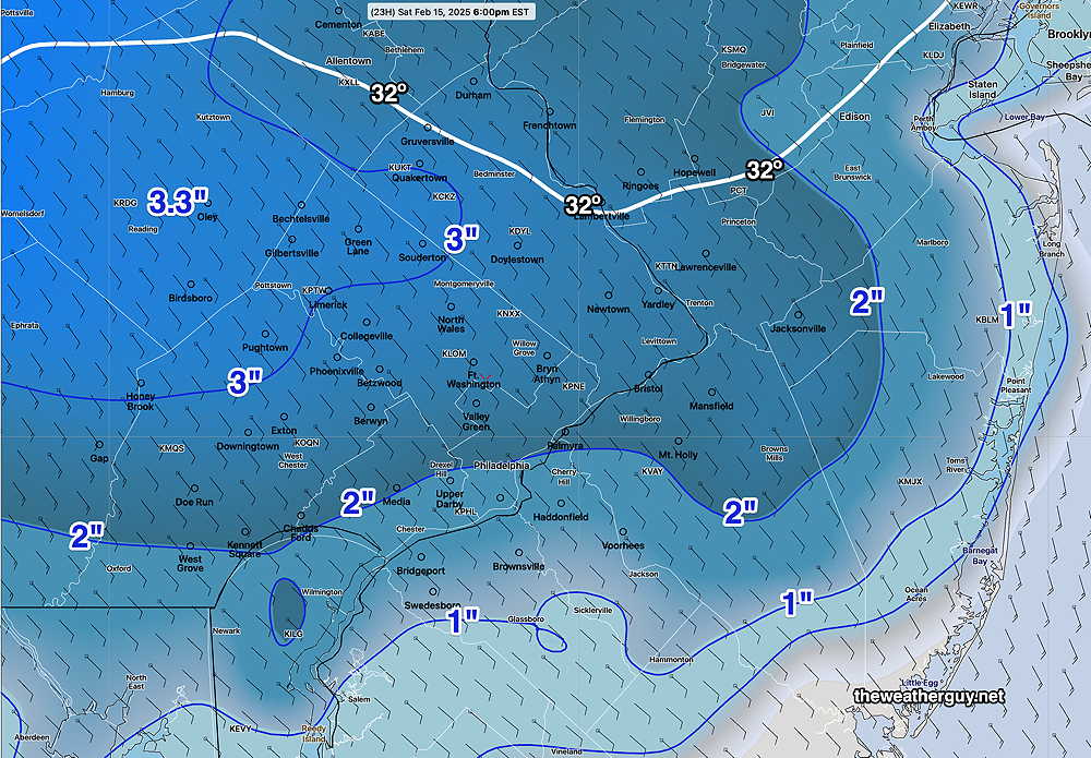
Here’s the latest NBM snow accumulation forecast—
When it comes to snow, long-time readers of this blog know I can’t ignore the NAM. The NAM is forecasting an unreasonably large snow accumulation—
Snow moves in about 12 noon to 2 PM, a bit earlier in far western suburbs.
Not mentioned earlier is the considerable rainfall we’ll receive this weekend. Most models are in the 1.3″-1.5″ water range.
Wet and Windy Weekend
Low pressure developing in the central US will move north towards the Great Lakes and will bring rain to our area Saturday, beginning around 12 PM – 2PM as some accumulating wet snow and then transitioning to all rain by 5 PM, if not sooner.
Rain continues Saturday night through much of Sunday, as a secondary low pressure system develops off the NJ coast on Sunday.
Saturday Forecast
Cloudy with wet snow or rain mixed with snow developing by 12PM to 2 PM The latest NBM shows some accumulation, but I think it may be over-done a bit. (The latest GFS shows somewhat more snow)—
NBM high temperatures: Blue Bell, PA 38º Philadelphia, PA 41º
High Uncertainty (based on standard deviation): ± 2.4º
Sunday Forecast
Continued cloudy with rain. Quite warm but very windy! Possibly a thunderstorm ahead of a cold front. Temperatures fall following the cold front Sunday late afternoon into the evening.
NBM high temperatures: Blue Bell, PA 61º Philadelphia, PA 58º
Average Uncertainty (based on standard deviation): ± 1.6º