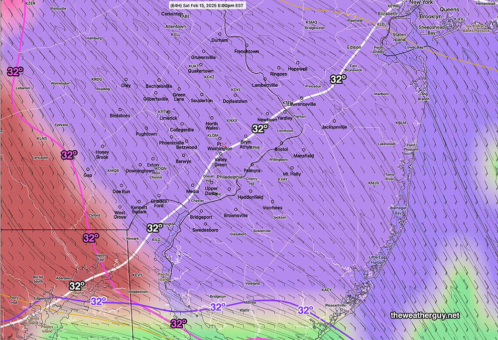
Posted Thursday 02/13/25 @ 8:47 PM — Accumulating snow on Saturday afternoon looks less likely. Possibly a coating in northwest suburbs before a changeover to rain.
Posted Thursday 02/13/25 @ 9:28 AM — Several large shifts in temperature and weather over the next several days.
Today (Thursday) — Clearing around 2-3 PM and becoming windy and gusty. Mild but temperatures chill down later today and tonight.
Friday (Super Bowl Parade) — Sunny breezy and cold.
Saturday— Snow develops in the morning from west to east. Precip changes to sleet, then rain early evening hours. Preliminary snow accumulation (GFS model) about 1-3 inches mostly from the city north and west.
Today’s 06z GFS forecast for 5 PM Saturday showing precipitation type (PTYPE) (violet= snow) surface temperature (white contour) and low level vertical temperatures (magenta, purple contours) Shading is PTYPE; it does NOT indicate the exact coverage or intensity of the precipitation at that time. (Click on image for a larger view.)
Wednesday Night through Friday
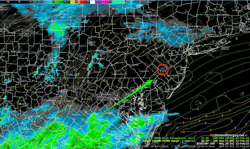
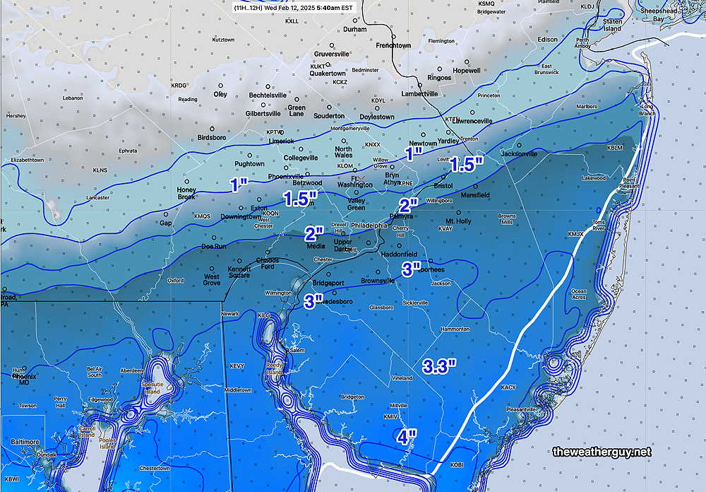
Posted Wednesday 02/12/25 @ 5:13 PM — Our next in a series of disturbances is approaching and should be here by 6 PM -8 PM—
MRMS radar around 5 PM with superimposed RAP model 700 mb winds and Omega (Click on image for a larger view.)
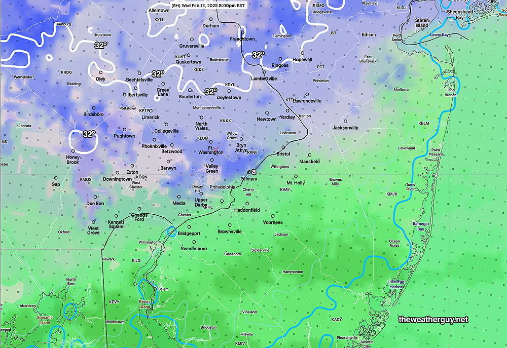
Temperatures in most of the region will be above freezing, but some of the earliest precip may begin as light snow, quickly changing to rain.
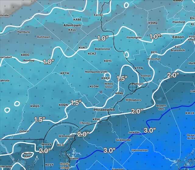
NBM temperature and precipitation type at 8 PM Wednesday evening. White contour is 32º line (Click on image for a larger view.)
Total rainfall is expected to be about 0.45 to 0.65″ tonight with higher amounts in South Jersey and near the coast.
Thursday: Cloudy in the morning, then sunshine breaks out in the afternoon. Windy and gusty with highs in the low 50s!
Friday: The Super Bowl Parade will have sunshine and breezy conditions. High temperatures will be near 37º in the city.
Rain Wednesday night
Posted Wednesday 02/12/25 @ 9:44 AM — The models maintain cloudiness for us today, Wednesday. Many models crank out some very light snow or flurries beginning in the afternoon. (Temperatures in the upper atmosphere remain cold enough for snow from the city northwestward despite temperatures moving above freezing for much of the area.)
NBM precipitation Type at noon Shading doesn’t mean it’s snowing or raining, just the conditionalprobability of snow or rain in an area at this specific time.. (Click on image for a larger view.)
As another area of low pressure slides towards us, temperatures at all levels will rise above freezing. Total additional rainfall about 0.30″-0.40″ water by Thursday 8 AM.
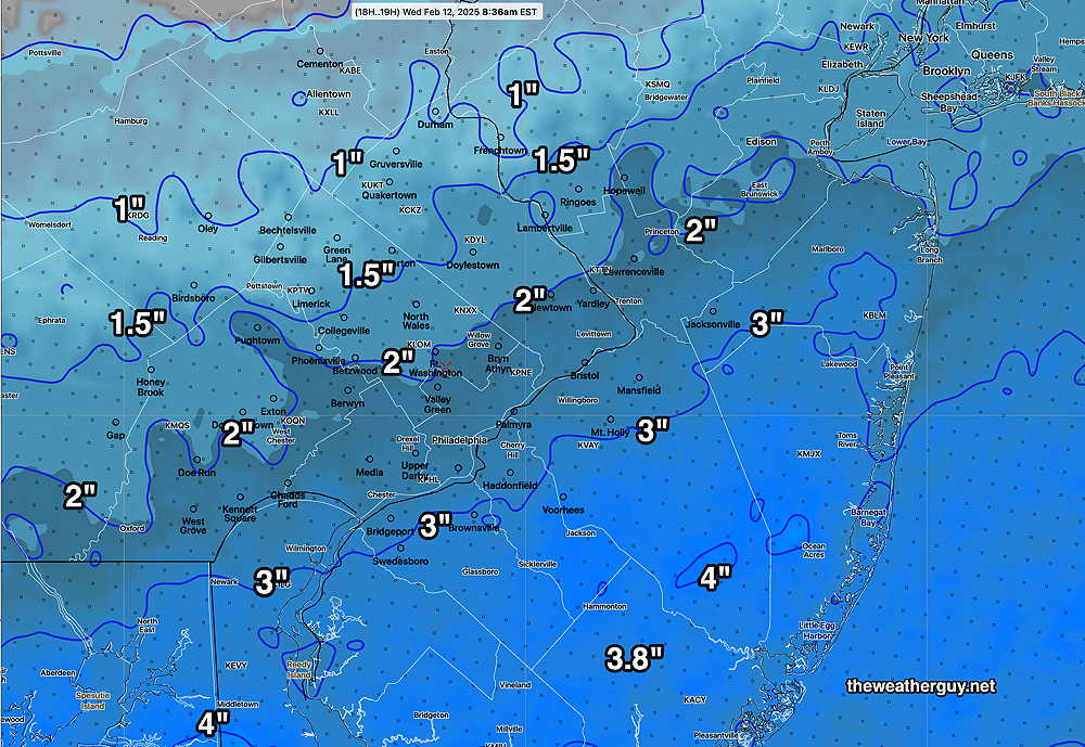
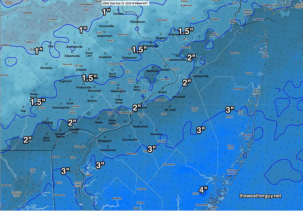
Wed 9:23 AM —Forecast Review —The immediate Philadelphia area received slightly more precipitation in the form of snow than forecast below by the NBM . Areas to the west and north received slightly less than forecast. Areas in NJ received somewhat more than forecast. Overall, the forecast was fairly good.
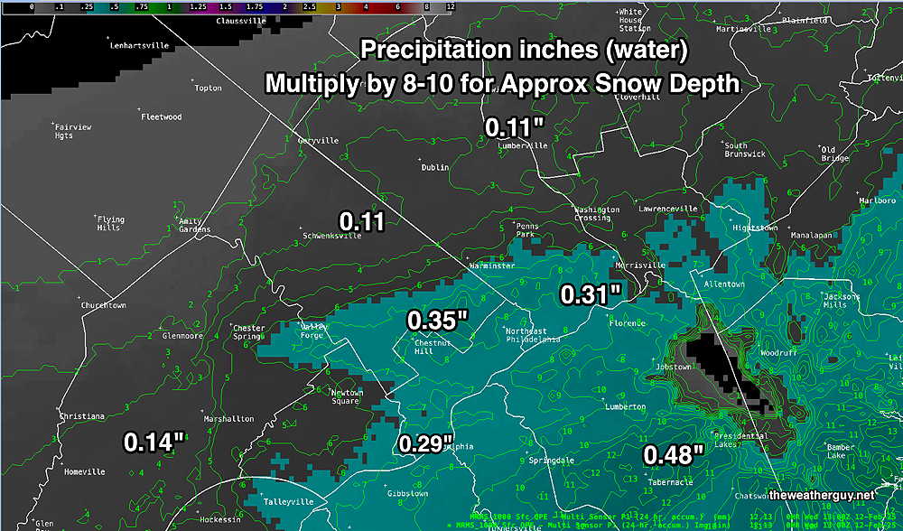
Here’s the MRMS precipitation estimate for the past 24 hours given in inches of water. Based on actual measurement, multiply by 8-10 to get approximate snow depth.
MRMS rain-gauge measured rainfall combined with rain-gauge calibrated and interpolated radar-based summary of ACTUAL PRECIPITATION RECEIVED. Color shading is in inches. Line contour numbers are in mm. (25.4 mm= 1 inch) (Click on image for a larger view.)
...Bucks County...
Levittown                    3.5 in    0548 AM 02/12   Trained Spotter
2 ESE Newtown                2.5 in    0634 AM 02/12   Other Federal
1 NNW Langhorne              1.8 in    1130 PM 02/11   Trained Spotter
Upper Southampton Twp        1.6 in    1250 AM 02/12   Trained Spotter
Plumstead Twp                1.6 in    0430 AM 02/12   Trained Spotter
Bensalem                     1.5 in    1024 PM 02/11   Public
Fricks                       1.5 in    0709 AM 02/12   Trained Spotter
Furlong                      1.0 in    1230 AM 02/12   Trained Spotter

...Chester County...
East Nantmeal Twp            3.3 in    0700 AM 02/12   Trained Spotter
Berwyn                       3.2 in    1038 PM 02/11   Trained Spotter
West Chester                 3.1 in    0600 AM 02/12   Public
Jennersville                 2.7 in    0556 AM 02/12   Public
1 WNW Chesterbrook           2.7 in    0634 AM 02/12   Trained Spotter
West Caln Twp                2.5 in    0553 AM 02/12   Trained Spotter
East Coventry Twp            2.0 in    0530 AM 02/12   Public

...Delaware County...
Boothwyn                     3.7 in    0120 AM 02/12   Trained Spotter
Chadds Ford Twp              1.8 in    1000 PM 02/11   Trained Spotter

...Montgomery County...
Norristown                   3.1 in    0613 AM 02/12   Trained Spotter
Plymouth Meeting             3.0 in    0100 AM 02/12   Public
King of Prussia              2.7 in    0604 AM 02/12   Trained Spotter
1 E Willow Grove             2.5 in    0600 AM 02/12   Trained Spotter
Eagleville                   2.3 in    1200 AM 02/12   Public
1 NNE Willow Grove           2.0 in    1228 AM 02/12   Public
Eagleville                   2.0 in    0630 AM 02/12   Trained Spotter
New Hanover Twp              1.9 in    0500 AM 02/12   Trained Spotter
East Norriton                1.8 in    1100 PM 02/11   Public
1 ENE Plymouth Twp           1.6 in    1222 AM 02/12   Public


...Philadelphia County...
Philadelphia Intl Airport    3.1 in    0700 AM 02/12   ASOS
1 SSE Center City            3.1 in    0713 AM 02/12   Public
Bustleton                    3.0 in    0523 AM 02/12   Trained Spotter
Fox Chase                    2.9 in    0530 AM 02/12   Trained Spotter
Tuesday Snow Update
Posted Tuesday 02/11/25 @ 7:54 PM — Looking at the latest hourly models (RAP and HRRR), it appears that we may get even less snow than the recent NBM forecast posted. I see very little in the way of pressure falls off the coast and negative omega values are plentiful, meaning less dynamics to result in snow intensification.
The ‘heaviest’ snow (air quotes placed for a reason) is still forecast to occur between 9 PM and midnight, then taper and end around 3 AM.
Here’s the latest HRRR which shows additional snowfall from 6 PM onward—
HRRR 23z Additional snowfall from 23z (6PM) onward. Even this may be too high. (Click on image for a larger view.)
Posted Tuesday 02/11/25 @ 4:32 PM — Additional models have become available since my last update. Little has changed with total precipitation around the city ranging from 0.18″ to 0.28″ water equivalent. This translates into a similar snow forecast as described earlier.
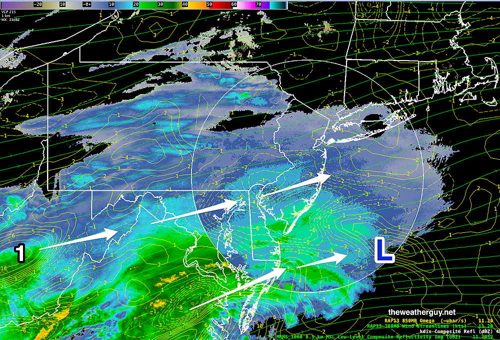
Currently light precipitation has just begun to fall in our area. As expected, the main area of precipitation is south of our area. Evaluation of vertical upward motion (“Omega”) shows low pressure will develop far off the Delmarva coast in the area designated (L) . In our area, there are little signs of intensification, but area of strong vertical motion in West Virginia now will bring some heavier snow here about 11 PM or so.
Evaluation of vertical upward motion (“Omega”) shows low pressure will develop far off the Delmarva coast in the area designated (L) . In our area, there are little signs of intensification, but area of strong vertical motion in West Virginia (1) now will bring some heavier snow here about 11 PM or so. (Click on image for a larger view.)
Despite somewhat heavier snow forecast from the ECMWF, I’m sticking with the latest model blend (NBM)—
19z NBM Snow accumulation forecast by 7 AM Wednesday. (Click on image for a larger view.)
Posted Tuesday 02/11/25 @ 1:08 PM— This morning’s models continue a trend towards somewhat lower snow totals. Here are the trends—
A somewhat later start of the snow; about 6 PM to 7 PM close to the city.
Snow ends well before daybreak Wednesday.
This morning’s GFS still shows some light snow or flurries early to mid afternoon before the main area of snow arrives between 6 PM and 7 PM.
Here is the latest model blend that incorporates the updated precipitation guidance—
13z NBM snow accumulation by Wednesday morning
Tuesday Snow Update
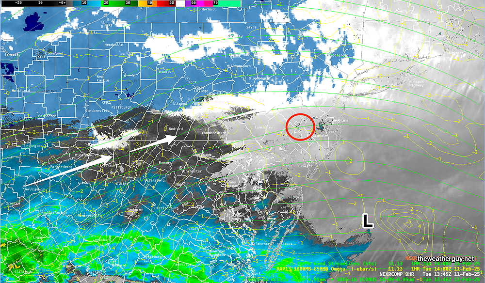
Posted Tuesday 02/11/25 @ 8:43 AM — Snow is still in the forecast for later today. Current water vapor and radar shows the main area of precipitation is to our south—
Water Vapor image with superimposed radar and RAP model parameters around 9 AM this morning. The “L” is the expected area of low pressure development off the coast, expected to expand the precipitation shield into our area this evening. (Click on image for a larger view.)
Here are the trends based on last night’s models—
I’m hearing the words “snow storm” and “3-6 inches” on the radio. Based on consistent model forecasts, I think this event is being hyped by some of the media. (The ECMWF is forecasting the higher totals.)
Most of our immediate area will receive 1-3″ of snow.
Snow begins 5 PM-7 PM although the GFS consistently shows an earlier brief period of light snow or flurries about 1-2 PM. Not all models are on-board with this earlier brief period.
Snow ends before daybreak, but some models continue with light intermittent snow into the morning hours.
Here’s the current NBM snow accumulation forecast—
07z NBM snow accumulation totals for Tuesday into Wednesday morning. Most areas receive 1-3 inches in the Philadelphia area and immediate suburbs. (Click on image for a larger view.)
Light snow develops again late Wednesday afternoon with a rapid changeover to rain.
A note for those of you who are visiting this site from “X“. Due to its highly unbalanced political environment, I’ve considerably cut back auto-posting there. To receive all forecast postings, I recommend following me on mastodon.social or bluesky.social
Active Weather Pattern- Snow Likely
Posted Monday 02/10/25 @ 6:03 PM — The latest GFS, just available, shows some light snow/flurries early afternoon Tuesday, before the main area of snow moves in between 4-7 PM.
Posted Monday 02/10/25 @ 5:17 PM — A quick update on the expected snow for Tuesday evening. Here are the trends—
Total accumulations have moved somewhat lower than had been forecast this morning.
Light snow moves in about 4-7 PM from the southwest.
Snow tapers to flurries between 8 AM and 10 AM Wednesday.
Snow re-develops Wednesday evening, but changes to rain. Rain may be heavy.
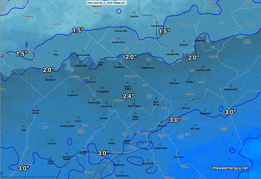
Here’s the latest model blend snow accumulation forecast—
Today’s 19z NBM model (model blend) forecast snow accumulation by Wednesday morning. (Click on image for a larger view.)
Posted Monday 02/10/25 @ 10:06 AM — One more thing… Following a break in the precipitation on Wednesday morning and early afternoon, snow will redevelop Wednesday evening, but change to sleet and rain. Heavy rain expected into Thursday.
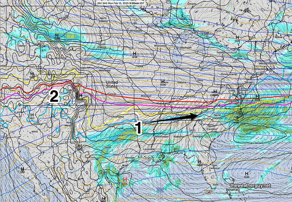
Originally Posted Mon 9:42 AM —As mentioned last Thursday, an air mass boundary stretching across the country will be a focal point of low pressure development this week.
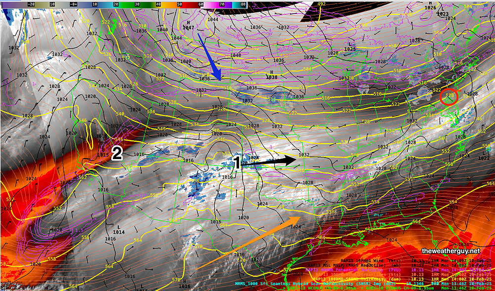
Here’s what it looks like on satellite water vapor imagery this morning—
Current satellite water vapor image with superimposed RAP model 500-1000 mb thickness lines (yellow), Mean Sea Level Pressure isobars (black contours) potential vorticity (fine violet contours) with superimposed MRMS RADAR. A wave (1) has already developed expected to bring snow later Tuesday. An area of potential vorticity (2) will be focal point of the next wave of precip on Thursday. Warm moist air is streaming up from the southern jet stream. (Click on image for a larger view.)
Here’s what the corresponding ECMWF weather map looks like—
Current 06z ECMWF surface forecast for the corresponding WV image above. (Click on image for a larger view.)
Snow is expected to move in during the afternoon on Tuesday and continue through Tuesday night.
ECMWF forecast for 1 AM Wednesday morning. Snow shield just makes it north of Philadelphia. Notice critical thickness lines (red magenta, yellow) are all south of our area, assuring all snow. (Click on image for a larger view.)
A large gradient of precip will set up, north to south, affecting snow totals. Small variations in the intensity and track of this storm will create large uncertainties in actual snow totals.
It should be noted that the AI version of the ECMWF has very little snow for us with this storm. So there’s high uncertainty with this forecast.
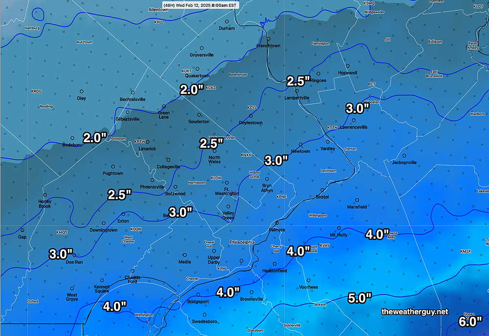
The NBM has been doing well with recent snow/sleet forecasts. Here’s its snow total forecast by Wednesday morning at 8 AM —
Latest NBM (13z) snow totals by Wednesday 8 AM (Click on image for a larger view.)