#Philadelphia #weather #PAwx
Thanksgiving Day Forecast Update
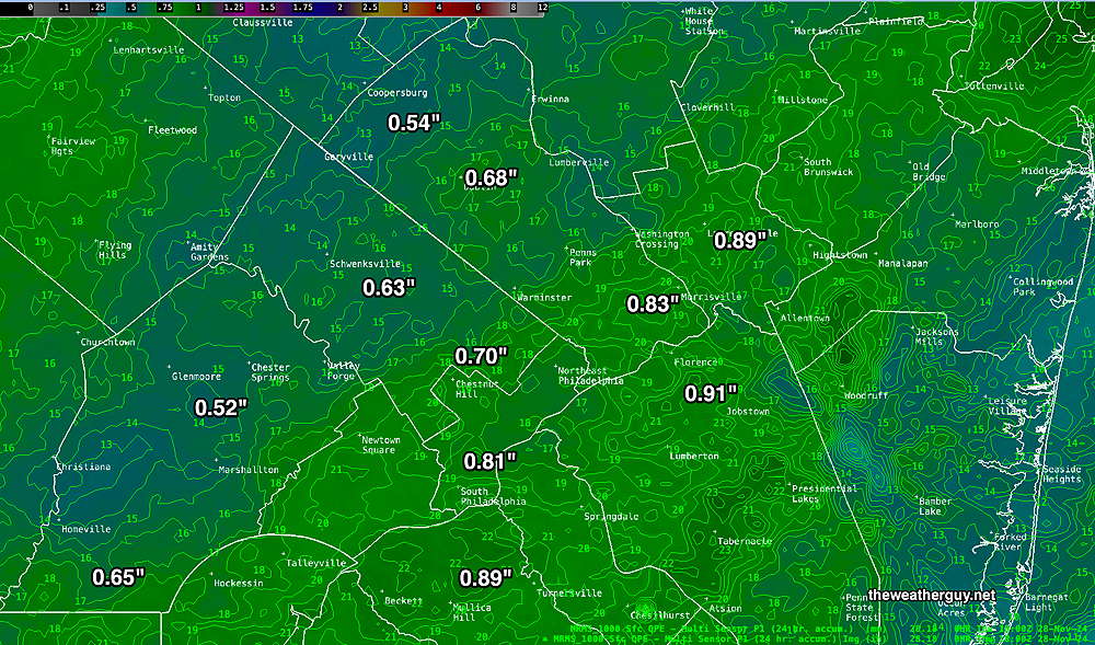
Posted Thursday 11/28/24 @ 1:42 PM — The rain has tapered off on schedule, about 1 PM. Most of the area received the rainfall predicted, about 0.60 – 0.90″ —
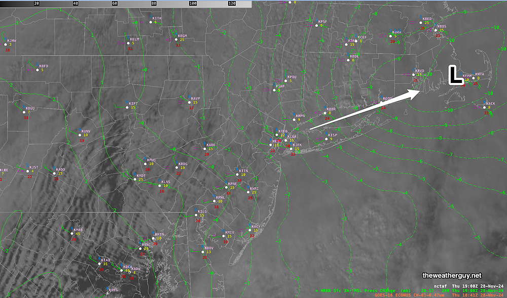
Based on the models, a considerable amount of cloudiness is still forecast for this afternoon, although the latest satellite image shows building high pressure and breaks in the overcast to our west—
Colder weather tonight and into the weekend. The latest RRFS (experimental) shows light scattered rain and snow showers Friday mid- afternoon —
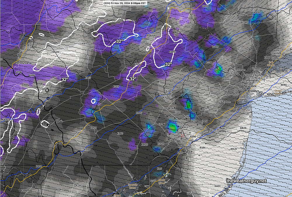
Note: the RRFS is still experimental but under active development and is increasingly used here for forecasts.
Thanksgiving Day Forecast Update
Posted Wednesday 11/27/24 @ 4:56 PM — The models have come together with the Thanksgiving Day forecast. Rain moves in between 1-3 AM and becomes moderate to heavy during the morning hours. The low pressure system exits and intensifies near NYC .
Rain is expected to taper off and end between 1 and 2 PM. It will still remain quite cloudy. Quite windy conditions develop about noon and continue into the afternoon with gusts 35-40 mph.
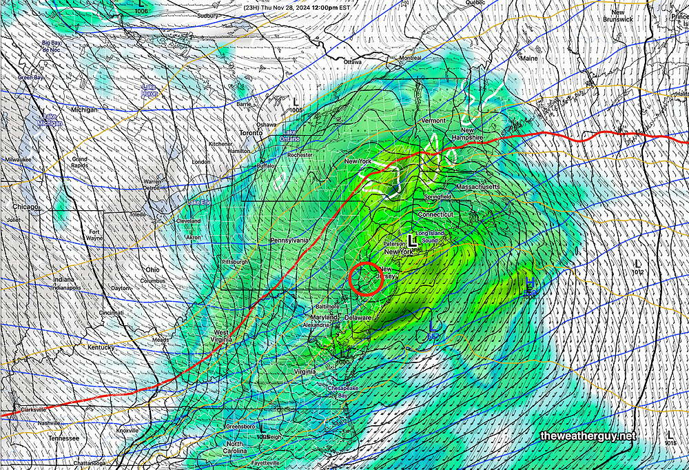
It will get cold Thursday night and colder into the weekend.
Friday starts sunny but instability cloudiness develops late morning and widely scattered rain showers are possible during Friday afternoon, especially northwest of the city. Far northwestern areas may see some snow showers.
Thanksgiving Day Forecast Update
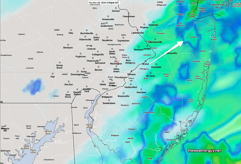
Posted Wednesday 11/27/24 @ 8:27 AM — Last night’s models show a faster moving storm and somewhat lower rainfall amounts for our area.
Most models show about 0.60″ of rainfall, starting about 2 AM Thursday morning and ending about 1-3 PM Thursday. (The GFS continues with about 0.8″)
Here’s the latest RRFS (experimental) model forecast for 2 PM showing the departing rain—
The weather pattern gets cold starting this weekend.
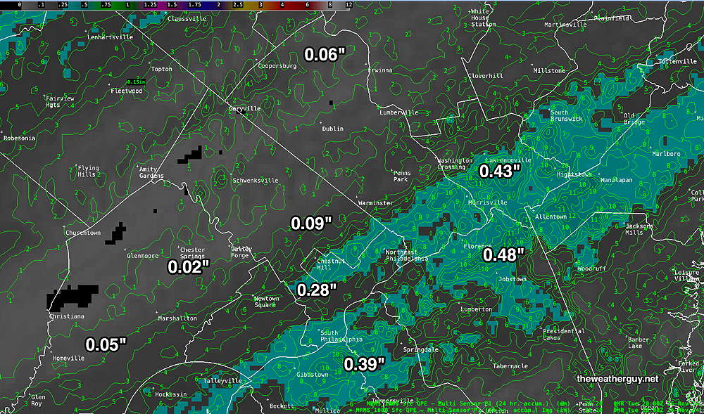
Posted Tuesday 11/26/24 @ 4:44 PM — The cold front moved through this morning and parts of our area had a ‘reasonable’ rainfall, while others did not.
Here’s the MRMS precipitation summary for this morning’s rainfall—
No significant change in the forecasts from my earlier updates for Wednesday through Friday.
Wednesday starts sunny but will have increasing clouds during the day. By 3-4 PM, it should be mostly cloudy.
Rain starts after midnight or closer to 2 AM Thursday morning. Moderate rain, heavier in the late morning, tapers off during the afternoon and may end as early as 3-4 PM, although the latest NBM has lingering sprinkles through 6 PM or so. Clouds linger into the evening. Windy and gusty!
The models are cranking out a generalized 0.65″ to 0.90″ with the usual scattering of lighter and heavier amounts.
Friday marks the beginning of a colder, mostly sunny and dry pattern that lingers through at least next week. Dry-passage cold fronts will bring high temperatures down quite a bit next week.
Tuesday and Thursday Forecast Updates
Posted Monday 11/25/24 @ 4:57 PM — Little change with the forecast for Tuesday and increasing clarification of the rain forecast for Thursday with a faster exiting storm .
A cold front moves through during the morning Tuesday. Showers will give us about 0.15″ to 0.20″ with the greater rainfall (as usual) falling north and west of the city. Skies clear and sun is expected by the early afternoon. Colder weather moves in for Tuesday night and Wednesday.
Wednesday will have clouds from the city westward in the morning, then increasing clouds west to east throughout our area.
Rain begins a few hours after midnight Wednesday and continues Thursday, Thanksgiving Day. It may be windy and gusty as low pressure intensifies off the NJ coast. Rainfall is consistently forecast to be in the 0.60″-0.80″ range.
For travelers on Thanksgiving, unfortunately it looks fairly rainy and somewhat windy.
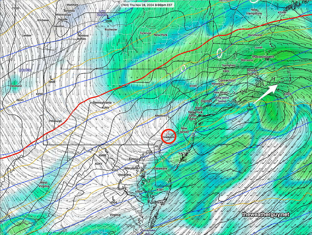
Rain may end about 2-3 PM around Philadelphia and towards evening in NJ according to the latest GFS and ECMWF models which is a quicker exit than previously forecast.
Latest GFS with the rain exiting about 3 PM Thursday—
Dry, windy and colder Friday with periods of instability low level cloudiness
Thanksgiving Weather
Originally Posted Sun @ 8:55 PM — —This week’s active weather pattern will be highlighted by a cold front that moves through Tuesday morning with some showers, followed by colder temperatures. Another highlight will be a storm that approaches Wednesday night into Thursday morning bringing rain to our area.
The models are in good agreement with the cold front passage Tuesday morning. Most are cranking out 0.25 inches of much needed rain with this front. Colder temperatures are expected Tuesday night into Wednesday.
A storm approaches late Wednesday night into Thursday. There’s been considerable uncertainty about both the track of this storm and its intensity. Much has to do with the size and configuration of the mass of cold air that descends down following the cold front on Tuesday.
The AI models have had a faster, more southern track with little intensification of this storm and very little rain for us. The latest GFS is somewhat similar.
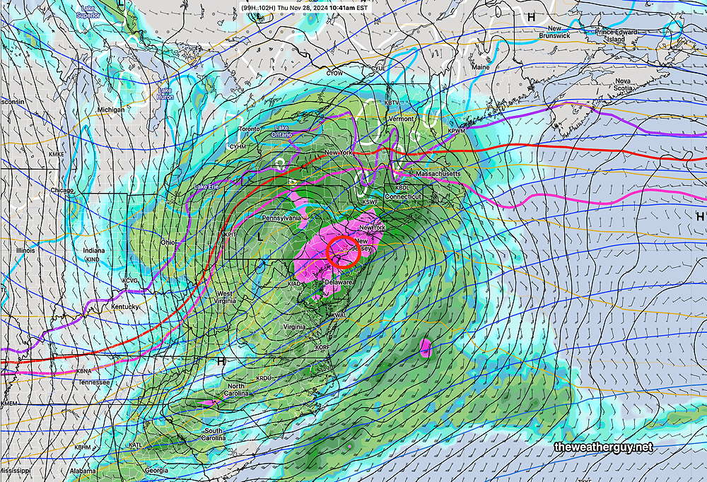
However most of the models have moved towards a track that is further north with greater intensification and brings about 0.75 inches of rain for our area.
The latest ECMWF is most aggressive with this system —
Since there’s so much spread in the models, I expect there will be further changes in the forecast for Thanksgiving Day. Stay tuned.
