#Philadelphia #weather #PAwx
Sunday through Wednesday
Posted Sunday 06/16/24 @ 9:23 AM — Sunny skies today with highs 87º Blue Bell and 88º Philadelphia with a average confidence level of ± 1.6º.
Looking at the latest NBM just available, forecast high temperatures for Monday through Wednesday have come down a smidgen— instead of mid 90s, the highs are closer to the low 90s.
| MONDAY | TUESDAY | WEDNESDAY | |
| BLUE BELL | 89.0 | 92.3 | 92.8 |
| PHILADELPHIA | 89.7 | 93.1 | 93.6 |
Higher temps into the mid 90s expected by the end of the week into the weekend.
Relief from the heat appears to come from a cold front not expected until next Monday afternoon or evening according to the ECMWF and the NAEFS. That’s eight days away and that forecast may change.

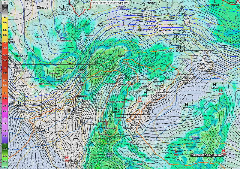
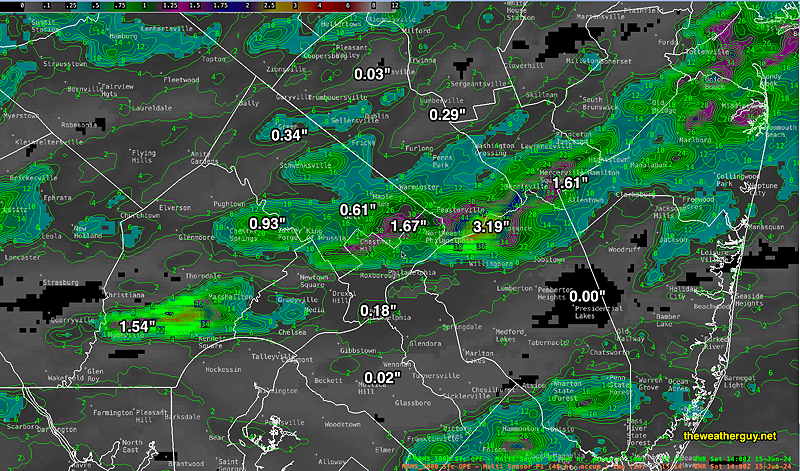
Yesterday’s Rain
Posted Saturday 06/15/24 @ 10:32 AM — As a follow up to yesterday’s forecast review, I wanted to post the 24 hour MRMS rainfall totals. Some areas received significant rainfall while many others in our area received very little. The location and timing of the heavier rain axis was not forecast by any of the models.
With the building upper ridge and heat wave expected beginning Monday, this rainfall appears to be the last until next Sunday into Monday, (June 24th) when another cold front may come through.
Posted Friday 06/14/24 @ 7:38 PM —I’ve posted an important Friday forecast review here.
Previously Posted Fri 3:59 PM —A cold front slowly moves through Friday night. The main batch of showers and thunderstorms move through to our north and to our south, with weak low pressure developing over Philadelphia about 11 PM. Some additional showers/rain towards midnight possible in the immediate Philadelphia area. Total rainfall will not be that impressive in some areas, while other areas, especially far north, may get some heavy downpours.
Everything clears out by morning for Saturday and Sunday. Sunny skies with very pleasant temperatures and low humidity for this entire weekend. A simple forecast, not needing any more details here.
The big story will be the change in pattern starting late Monday into Tuesday, with a shift to an upper level ridge and possible development of a heat dome bringing 90º+ weather here for next week and beyond. It will also be dry with no significant rainfall in the picture. The latest long range forecasts have backed off a bit on the 95º temps and have them closer to low 90s.
The NAEFS captures this change—