
#Philadelphia #weather #PAwx
Storm Update
Posted Sunday 09/15/24 @ 9:55 AM — A change in the forecast appears to be developing. First, cancel the GFS forecast from yesterday; it wasn’t believable and now most of it is no longer in-play.
The majority of models have come together (finally) with the an inland, northwestern storm track, but then have the storm blocked from further northward movement due to persistent blocking high pressure.
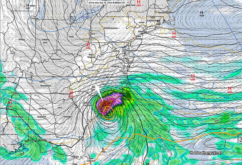
I’ve drawn the consensus track on the current water vapor image—
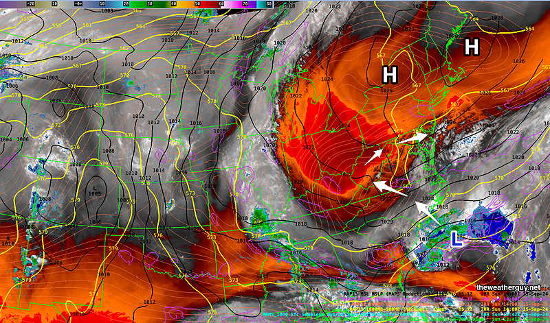
Unfortunately (and incredibly), several models have the main areas of rain blocked from reaching the Philadelphia area! At best, only 0.30 to 1.0 inches of rain will fall in our almost drought-stricken area, with most areas in the lower range.
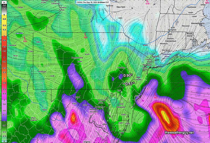
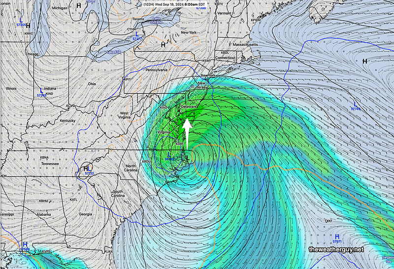
Here’s the latest GFS total rainfall through Thursday morning—
Undoubtedly, the forecast is likely to change again but this trend towards less rainfall here has been showing in an increasing number of models.
It should be noted that the ECMWF supports this trend for less rainfall here. The latest ECMWF-AIFS still has considerable rainfall for us but at this point, it’s an outlier.
Stay tuned
Potential Storm Update
Posted Saturday 09/14/24 @ 9:02 PM — I’ve rarely seen the model forecasts as strange as those for this upcoming week. A tropical system, maybe semi-tropical, will develop in the Atlantic and move into North Carolina. The speed of movement, the path, the intensity and the forecast beyond that point is a full range of possibilities. No single model forecast really is fully believable.
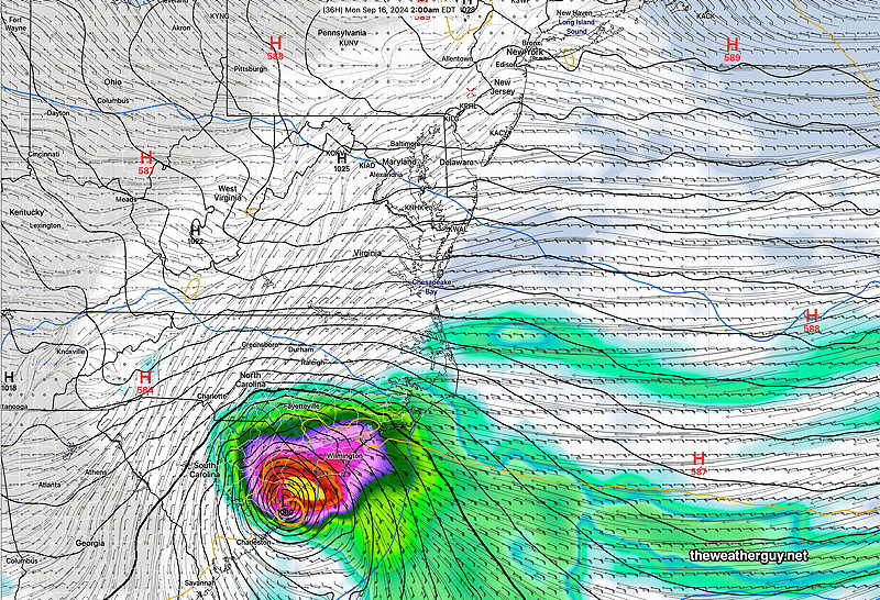
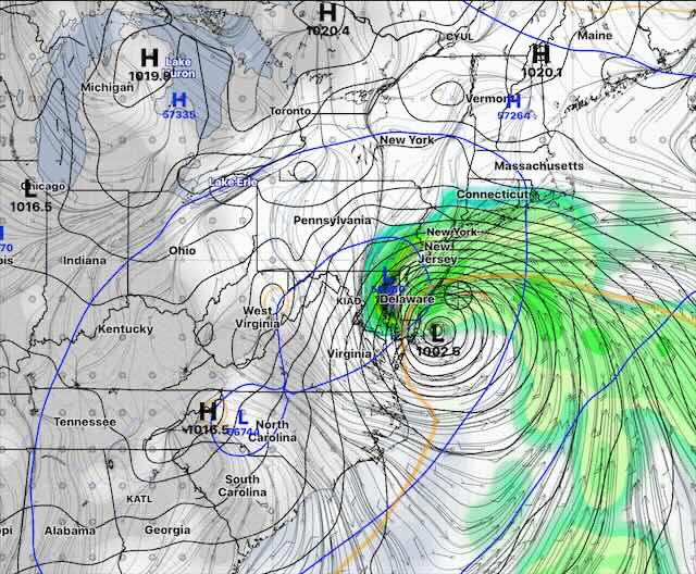
Case in point is the latest GFS which has it moving inland Monday morning, then dissipating, then re-forming again off the Delmarva coast, then moving westward again Friday evening.
GFS Monday Morning—
GFS Friday Evening Forecast—
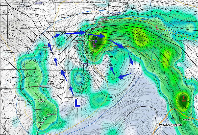
Other models end up with an inverted trough, a closed upper low, or another surface low pressure system or combinations of those three.
What the models have in common:
- Blocking high pressure will influence the path of this storm and slow its exit
- Rain starts in our area Tuesday afternoon or evening.
- Heaviest rainfall Wednesday.
- Rainfall may linger on again off again into Friday.
- Total rainfall here may be as little as 0.75″ or 2″-3+”
More info tomorrow.
Rain Next Week!
Posted Saturday 09/14/24 @ 10:45 AM — Following a wonderful weather weekend, we may finally be getting some much needed rain next week.
The models are coming somewhat closer together in forecasting a semi-tropical system to develop off the North Carolina coast and then slowly move towards us.
However the track, speed and development of this system still varies from model to model. Most models, despite differences in speed and track, have rain here by Tuesday evening into Wednesday and possibly beyond that.
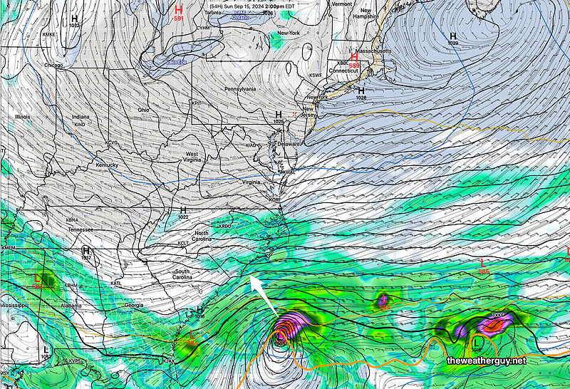
The latest GFS has the storm moving inland—
The latest ECMWF-AIFS has joined the rest of the models with more of a coastal storm and a coast track—
The latest German ICON model is fastest and has a track between the ECMWF-AIFS and the GFS—
Either way, it’s looking more likely that we’ll get some much needed rain this coming week.
Stay tuned for updates.
Food for Thought
Update Fri 9/13 9:27 PM — The forecast for a tropical storm affecting our area next week remains highly uncertain. Here’s the latest ICON model. Just food for thought at this time—
Originally Posted Fri 6:00 PM —
High pressure continues to block the rain and moisture from what was hurricane Francine from moving towards us. Sunny skies and warm temperatures to continue here for the weekend.
Meanwhile energy and moisture associated with Francine is forecast to become incorporated in a potential new tropical system that moves towards North Carolina early next week—
The models are all over the place regarding this forecast, with the ECMWF, ensembles and the Canadian Global only showing an inverted trough with some rain here by Wednesday, while the GFS and the German ICON model show a distinct tropical-type system to possibly affect our area.
The ECMWF AIFS. which I started using this past week, has been very inconsistent and shows a distinct system far off the coast. So much for artificial intelligence.
The GFS is known to over-forecast tropical development, so there remains much uncertainty with this forecast. I don’t see any unifying forecast at this time, but many models have some rain here by late Tuesday into Wednesday. Low confidence.
I’ll be updating over the weekend. Stay tuned.