
#Philadelphia #weather #PAwx #PhillyWx
Friday Update
Posted Friday 07/18/25 @ 10:49 AM — It appears that the front didn’t clear our area and stalled somewhat north of the expected location. More clouds possible today. I’ll give a complete weekend forecast early this evening.
Very Hot Thursday- Unimpressive Storms
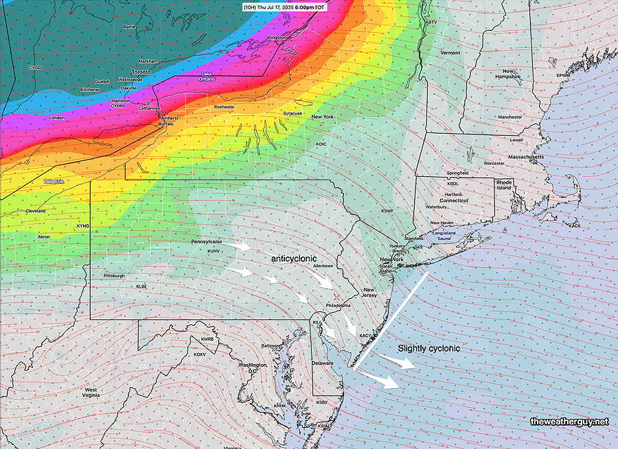
Posted Thursday 07/17/25 @ 11:44 AM — With all the heat and humidity forecast (high temps near 95ª, dew points near 74º), you’d think we would have the perfect set up for afternoon and evening thunderstorms as a weak front moves through. That’s not the case today and the question is why?
The answer often seems to depend upon the jet stream winds, which in our area will be curved in an anticyclonic direction, causing downward motion. Additionally, any lift from being near a favorable region of jet streak will not occur; the jet is far to our north and we are in a non-favorable region.
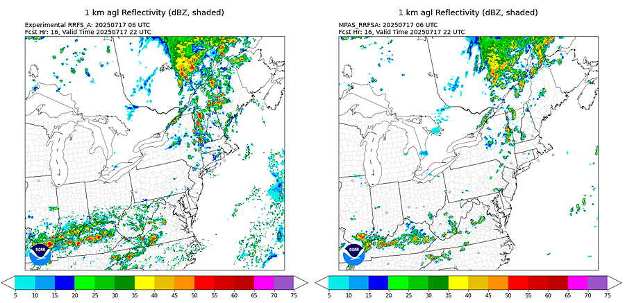
The REFS shows isolated, very light, fast moving showers this evening —
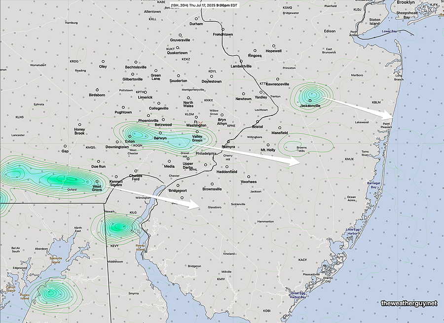
There’s also a question about the timing of these showers, with some models showing 6 PM and others later. Case in point is the RRFS and another experimental version called the RRFS-MPAS
Hot Wednesday
Posted Wednesday 07/16/25 @ 9:30 AM — A hot very humid flow of air remains over our area. A disturbance in Ohio this morning will move towards our area today sparking showers and thunderstorms.
The latest models show isolated showers developing in western sections as early as 3-4 PM with a significant increase in scattered activity between 6 PM and 10 PM. Some of the heaviest activity may occur as late as 1 AM Thursday morning.
Vertical shear is low as is helicity. Severe weather not likely, but still possible. The atmosphere is quite unstable.
Total rainfall forecast range is quite large with the Canadian RGEM showing areas as much as 1″+ of rain while the NBM is showing less than 0.5″ near the city. Heaviest rain will occur near Reading and northwestward.
Tuesday Uncertainty
Posted Tuesday 07/15/25 @ 10:42 AM — Just enough time for a quick update. Uncertainty in today’s forecast. NAM-NEST shows low clouds hang tight in many areas this afternoon. I’m mentioning the NAM-NEST because it tends to do well with these sort of things. RAP and HRRR shows clouds break up to partial sunshine. Most models have no rain during the afternoon. Model Blend (NBM) also shows reduction in clouds in the afternoon. RRFS/REFS not available today. So a low confidence forecast for some clearing and most areas dry this afternoon.
Monday Eve Heavy Rain Update
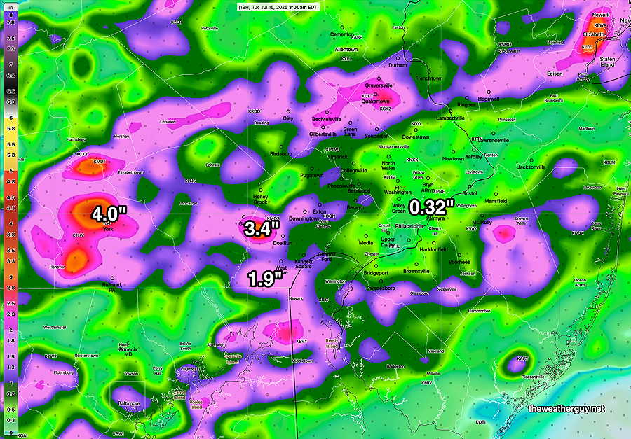
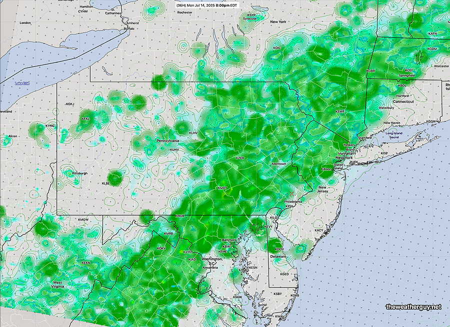
Posted Monday 07/14/25 @ 4:21 PM — The expected batch of storms is developing as expected to our west. I’m still going with the REFS timing of it moving into the immediate Philadelphia area between 5 and 6 PM.
A change in the forecast, based on the latest REFS: the area of storms will exit about 2 AM from the immediate PHL area and will not linger into Tuesday morning.
A wide range of rainfall totals, as is often the case, is expected.
Posted Monday 07/14/25 @ 9:42 AM — This morning, I wanted to wait for the latest model runs before posting. As mentioned yesterday, a weak, slow moving upper level trough will move across our area and act as a trigger for somewhat more organized thunderstorm development today.
The timing has shifted somewhat later, now into the evening hours, moving in as early as 6 PM with maximum activity between 7-8 PM and midnight. However, it should be pointed out that the AI versions of the ECMWF and GDPS have widely scattered activity possible for most of the afternoon into the evening, especially western sections.
It may get hung along the Jersey coast with showers lingering here near the city well into Tuesday morning.
Heavy rain will be the ‘feature’ of today and tonight’s activity and the REFS is showing areas receiving as much as 1″-4″. Aside from the heavy rain and lightning threat, severe activity looks to be low.
A considerable amount of cloudiness is expected today from the city westward, but areas in NJ may see considerable sunshine. High temperatures will be in the mid 80s, not likely hitting 90º unless the cloud cover forecast is wrong. High humidity expected with dew points in the 70s. The NBM shows 88º for today.
While not a severe thunderstorm day, I thought I’d compile a severity table to give a sense of what elements are missing today for severity to be likely—
| Severity Parameter (HRRR) | Sept 1 , 2021 Tornado Outbreak (example of highly severe) | 4-1-23 Tornadoes (Example of severe) | 08-07-23 18z HRRR Bow Echo | 07-08-25 18z HRRR & Impact | Today 07-14-25 HRRR & Impact | Notes |
| CAPE Joules/kg | 3500-4200 ⚑⚑⚑⚑ | 2100 ⚑⚑ | 2600 ⚑⚑ | 2680 ⚑⚑ | 2900 ⚑⚑ | Western Areas |
| Helicity m^2/s^2 | 1350 ⚑⚑⚑⚑⚑ | 655 ⚑⚑ | 726 ⚑⚑ | 403 ⚐ | 161 ⚐ ⇩ | |
| Vertical Shear 1/sec | 40-46 ⚑⚑⚑ | 40-45 ⚑⚑⚑ | 30 ⚑ | 20 ⚐ ⇩ | 18 ⚐ ⇩ | |
| Precipitable Water | 2.7″ ⚑⚑⚑⚑ | 0.83” ↓ | 2.1″ ⚑⚑ | 2.6″ ⚑⚑⚑⚑ | 2.3″-2.5″ ⚑⚑⚑⚑ | Heavy rain potential |
| Lifted Index º K | minus 6º ⚑⚑ | minus 9.3º ⚑⚑⚑ | minus 9.9º ⚑⚑⚑ | Minus 8.3º ⚑⚑ | Minus 7.0º ⚑⚑ | |
| HRRR Hail inches | 1.9 ⚑⚑ | 1.4 ⚑ | 1.8 ⚑⚑ | 1.8 ⚑⚑ | 1.8 ⚑⚑ | |
| Peak Wind Gusts mph | 40-50 ⚑⚑ | 40-50 ⚑⚑ | 65mph ⚑⚑ | 51.6mph ⚑⚑ | 30 mph ⚐ | western areas |
| Storm Motion Shear Vector Alignment | Aligned – ~ 90º ⚑⚑ | Almost aligned ⚑⚑ | aligned ⚑⚑ | Somewhat aligned ⚑ | Not aligned ⚐ ⇩ | |
| 250 mb Jet Stream Wind mph | 63 ⚑ | 135 ⚑⚑ | 74 ⚑ | 41 ⚐ ↓ | 24 ↓↓ |
I’m planning to use the RRFS going forward instead of the HRRR. Some of the parameters won’t be exactly equivalent. Due to the slow downloads of a still-experimental model being hosted on a non-production server, I don’t download all equivalent parameters at this time since downloads take 3-5 times more time. Additionally, the availability lag time for the HRRR is about 1.5 hours or less. The availability lag time for the RRFS is about 3-7 hours depending on the forecast range.
| Severity Parameter (HRRR) |
Sept 1 , 2021 Tornado Outbreak (example of highly severe) |
4-1-23 Tornadoes (Example of severe) HRRR |
Today 07-14-25 HRRR 12z |
Today |
Notes |
| CAPE Joules/kg |
3500-4200 ⚑⚑⚑⚑ |
2100 ⚑⚑ |
2900 ⚑⚑ |
2900 ⚑⚑ |
western sections |
| Helicity m^2/s^2 |
1350 ⚑⚑⚑⚑⚑ |
655 ⚑⚑ |
161 ⚐ ⇩ |
330 ⚑⚐ |
Far Northwest |
| Vertical Shear 1/sec |
40-46 ⚑⚑⚑ |
40-45 ⚑⚑⚑ |
18 ⚐ ⇩ |
18-22 ⚑ |
|
| Precipitable Water | 2.7″ ⚑⚑⚑⚑ |
0.83” ↓ |
2.3″-2.5″ ⚑⚑⚑⚑ |
2.2″-2.4″ ⚑⚑⚑⚑ |
Heavy rain potential |
| Lifted Index º K |
minus 6º ⚑⚑ |
minus 9.3º ⚑⚑⚑ |
Minus 7.0º ⚑⚑ |
Minus 6.7º ⚑⚐ |
|
| HRRR Hail inches |
1.9 ⚑⚑ |
1.4 ⚑ |
1.8 ⚑⚑ |
||
| Peak Wind Gusts mph |
40-50 ⚑⚑ |
40-50 ⚑⚑ |
30mph ⚑⚑ |
25 mph ⚑ |
|
| Storm Motion Shear Vector Alignment |
Aligned – ~ 90º ⚑⚑ |
Almost aligned ⚑⚑ |
Not aligned ⚐ ⇩ |
n/a | |
| 250 mb Jet Stream Wind mph |
63 ⚑ |
135 ⚑⚑ |
24 ↓↓ |
||
| Max Updraft Velocity |
116 |
North and Northwest | |||
| Max 850 DZDT |
28 m/s |
Buck County |
↓ indicates works against Severity ⇩ Significant, but less impact
Originally Posted Sun 8:11 PM —This week’s weather will continue to be warm/hot and very humid through at least Friday. With the exception of Monday, most of the weather will consist of random areas of thunderstorms developing from small, localized mesoscale disturbances.
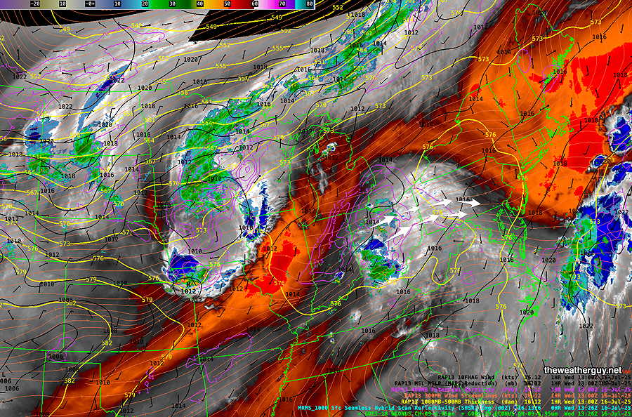
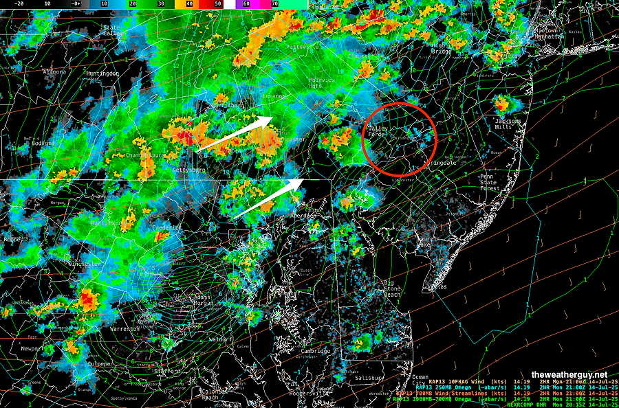
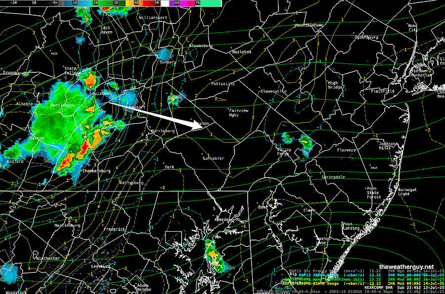
On Monday, a weak, slow moving disturbance and upper trough will create somewhat more organized storms, especially towards evening. Some of that activity has been developing in Central PA this afternoon and may move into our immediate area, especially western sections this evening—
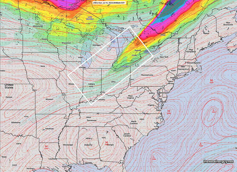
The upper trough and diminishing jet streak is visible with the GFS forecast for Monday morning—
Following any morning showers, Monday should become partly to mostly sunny through high clouds. Showers and thunderstorms move in from the west between 4 PM and 9 PM, but may lose upper support as they try to move past the city into NJ.
The rest of the week looks just like typical summer weather. Highs near 90 and VERY humid with scattered late day storms, too difficult to predict in advance.
Updates during the week. Stay tuned.
Models used for this forecast: GFS GDPS-AI, ECMWF-AI , REFS, RRFS