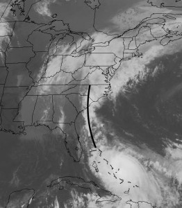
The direct effects of Hurricane Joaquin will not be felt by us; it appears that the storm will be a few hundred miles out to sea at its closest approach. (I’m not referring to the marine and coastal forecast; we’ll leave that to the highly qualified meteorologists at the NWS.)
By the way, I’m really disappointed with how the Navy NAVGEM forecast was so off. I guess I can’t rely on it, as I had in the past with the now-discontinued Navy NOGAPS model.

Joaquin is throwing back a significant moisture plume into the stalled frontal boundary and our heavy rains today are due to this source of tropical moisture.
While I think we do have a handle on the future path of the hurricane, its presence always affects the non-tropical weather models. So the forecast for this weekend is low confidence, despite our knowledge of the hurricane’s path.
I’m far from being a numerical model scientist, but it’s my humble guess that a tropical storm represents some sort of mathematical discontinuity in the model physics. It’s been my experience that the model forecasts suffer with any deep tropical storm in the picture, even when predicting the non-tropical elements.
So with that said, Saturday looks like rain will be tapering in the morning and may end late morning or early afternoon. (However, the latest GFS LAMPS forecast now shows rain continuing well into the afternoon. 🙁 Highs will be in the mid to upper 50s.
For Sunday, look for mostly cloudy skies (maybe some sunny breaks) and dry. A quick shower can’t be ruled out in the afternoon. High near 63.
I don’t try to second guess the models and I’ve learned they can’t be relied upon in this sort of scenario. So we’ll have to see what actually happens this weekend.
