As mentioned in past posts this week, two areas of low pressure will combine Thursday night to form a significant coastal storm off the Delmarva coast Friday. This storm will intensify and become somewhat fixed in position as blocking high pressure in the Atlantic prevents its usual movement away.
While the temperatures during Thursday and Thursday night will be well above freezing, intensification and heavy precipitation rates during the morning on Friday (QPF values over 0.75 inches in 6 hours) will cause dynamic cooling.
The NAM shows rain changing over to wet snow in Philadelphia sometime during the morning hours Friday and earlier north and west of the city.
While warm ground surface temperatures and spring-like solar insolation effects (radiant energy through the clouds) will seriously reduce the chance of accumulations, it will look quite stormy out with windy conditions adding to the mix on Friday.
Some surface accumulations possible especially on grassy surfaces, if the precipitation continues into the evening Friday.
An interesting and unusual weather system setup! Expect changes to this forecast.
As mentioned yesterday, a coastal storm is expected to develop along the Delmarva coast Thursday through Friday as a result of two impulses merging and phasing. A blocking pattern in the Atlantic will cause this storm to linger from Thursday into Friday and then slowly move eastward. Rain with windy conditions is expected with a possible mix in of wet snow Friday morning with little if any accumulation.
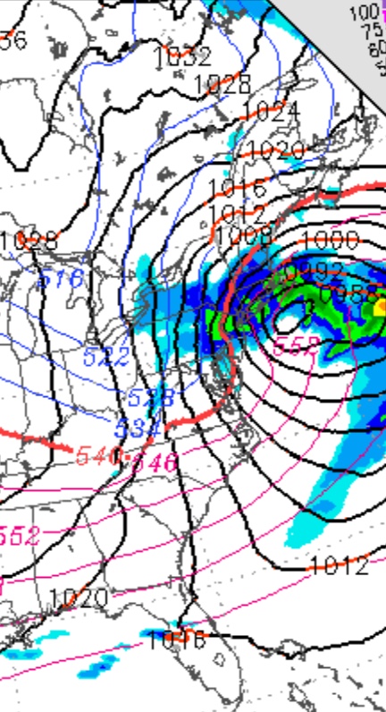
The latest models have this storm becoming a sort of impressive “superstorm” far off the coast on Saturday; other than windy conditions here and some significant maritime/ coastal issues, this superstorm won’t be a concern in PHL. This would change if intensification occurs earlier than forecast, but not expected at this time.
It looks like March will come in like a lion — The models have been showing the development of a coast low near the Delmarva area for Thursday into Friday. This low pressure system is expected to intensify and be blocked by high pressure over the Atlantic, causing it to linger. Temperatures are expected to be too warm for snow for much of the duration, but intensification may allow for cooling- wet snow is likely to mix during the end of the storm. Expect heavy rain for later on Thursday into Thursday night. A changeover to wet snow is possible early Friday morning; accumulations aren’t likely.
Exact degree of intensification, timing and the degree of blocking isn’t certain. I’ll keep an eye on this.
In a separate thought, this forecast storm has been hyped on the internet for days; I suspect that there’s so much ‘pent up demand’ for a “good snowstorm” this season that people are clamoring for a “big one”. Not me; I’m ready for Spring.