WEEKEND WEATHER FORECAST – FRI EDITION

This weekend’s Philadelphia weather forecast will be lower confidence than usual.  As mentioned, a frontal boundary moves south and stalls as waves of low pressure move along the front. The waves of low pressure may make the boundary quasi-stationary causing the boundary to undulate slightly north and south with each wave.

The timing of the waves and the exact placement of the front with each wave will determine our sensible weather.   There remain differences in timing with the GFS and NAM models.   I’m going to blend the two to attempt a forecast with an emphasis on the NAM.

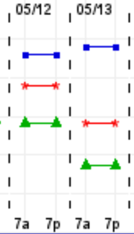
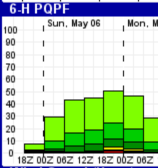
(Last week’s GFS over-predicted precipitation and it resulted in a poor forecast for both days; last week’s weather was forecast better by the NAM.)

Saturday starts damp and cloudy with possible showers ending early.  Expect skies to brighten mid-day and early afternoon, with even some sunshine possible.   Light winds and increasingly humid.   Showers and thunderstorms develop later in the afternoon and continue into the evening hours.   Some of the showers may be heavy.   High 82

NAM forecast Saturday evening
NAM forecast 8 PM Saturday

The front sinks to our south Saturday night.

On Sunday as an easterly flow develops. Cloudy and cool conditions (High 67) but not too wet,  according to the GFS, but the National Blend of Models (NBM) and NAM maintains a good chance of showers during the day Sunday and especially Sunday late afternoon into evening.


PHILLY WEEKEND WEATHER OUTLOOK

[su_note note_color=”#d9f2da”]Fri Noon Update: Large differences between the NAM and GFS models.  The NAM has much of Saturday dry, the GFS has much of Sunday dry with the NAM having heavy rain on Sunday.  I’ll try to nail it down with a Friday evening update. [/su_note]

A quasi-stationary  frontal boundary will gradually pass through our area over the upcoming weekend and become quasi-stationary.

There’s much uncertainty about the timing and speed of this front as well as the final position of the front.  Impulses of low pressure are expected to develop along this boundary and bring showers as well as pulling the front alternately north and south.

As a result, the forecast for this weekend is very low confidence, but here’s the general trend-  Saturday will be the most unsettled with the highest chance of precipitation;  showers and thunderstorms are possible, especially in the afternoon, but possibly throughout the day as low pressure develops right over Philadelphia.   These will continue into the evening.

Low pressure exits on Sunday, giving a break in the showers early, with showers possibly developing again in the evening.   Sunday looks like the better day for outdoor activities.

The experimental EKDMOS captures the uncertainty- the spread on the high possible temperatures for Sunday 5/13 is incredibly large.

High Temperatures for Saturday and Sunday EKDMOS

PHILLY FORECAST UPDATE

Broad Street Run Forecast Update-  We had a little more sunshine than predicted this morning.  I’m always glad to be wrong about this. Cloudiness did move in during the afternoon.

Some showers will be moving in Saturday evening.

For tomorrow, Sunday, the models continue with a break in precipitation during the morning hours for the Broad Street Run. Minimal precipitation expected in the morning hours (QPF< 0.01 inches water)  but rain returns after 2 PM.

It will be cloudy, cool with high temperatures in the mid 60s and a breezy north to northeasterly wind.

Break in PHL rainfall Sunday morning
Experimental GFS model-  Accumulated precipitation during the morning hours 8AM to 2PM Sunday. Most models keep the immediate PHL fairly dry in the morning hours.

While the operational models (NAM GFS)  maintain dry conditions in the morning, the statistical models maintain a chance of light precipitation during the morning. (12Z-18Z)

Ensemble Kernal Density Model Output Statistics (Experimental)

Weather… and Other Things 'Up in the Air'