Latest models suggest that only Saturday will be a washout. Looks like skies clear for Sunday, as the remnants of Harvey are moving faster than previously forecast.
I’ll update Friday evening.

Latest models suggest that only Saturday will be a washout. Looks like skies clear for Sunday, as the remnants of Harvey are moving faster than previously forecast.
I’ll update Friday evening.
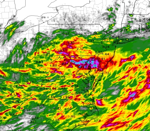
Friday Late Morning Update: Latest NAM model have the heaviest rain (2-3 inches) south of PHL. The NAM has the heavy rain accumulation tapering off rapidly as one goes to the north.
Below is the NAM 3KM forecast for accumulated precip by 8 AM Saturday.
Just a quick update. The models have been consistently advertising a very heavy rain event for Friday night into Saturday… until last night.
The most recent model runs from last night have shifted the very heavy rain to south of our area, into Delaware, MD and VA. It appears that the immediate PHL area will miss the heavy rain and areas north of PHL will be on the outer fringe of the rain shield.
This is not unlike the blizzards that get forecast, only to have the heavy snow occur elsewhere (or not at all).
The models are only so good in long time range- the general features of storm development are usually spot-on, but the details of moisture distribution and the location of the dynamics that go into heavy rain (or snow) formation often can’t be nailed down until 24 hours before the actual event.
Things may change again, but the current trend is for PHL to miss the heavy rain. I’ll update again later today.
BTW, I was looking at the models on Thursday and the maximum of heavy rain was very close to PHL….the models were suggesting 2-4 inches. What was strange, though, was that the statistical models were only showing 70% chance of rain. I couldn’t understand that, since with heavy rain like that being forecast, the statistical models usual show chances greater than 90%. Now it’s becoming clearer.
This coming weekend’s weather will be notable, not for the temperatures, but for the humidity. An unsettled weather pattern is expected with considerable cloudiness and scattered showers.
Most significant will be the humidity, with dew points near the uncomfortable 70 degree level.
I’ll try to nail down the timing of the showers tomorrow evening.