When we have such beautiful weather in August, there’s not much to write about. Sun, minimal clouds, light winds, smooth sailing.
High pressure will block the very hot weather to our west through early Monday.
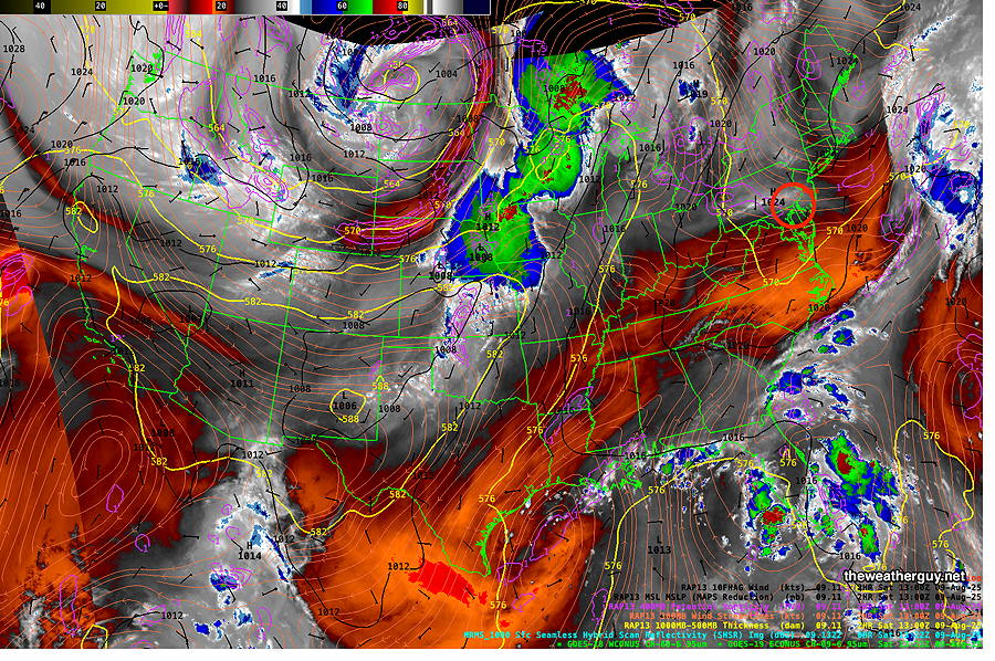
Current satellite water vapor image with superimposed RAP model 500-1000 mb thickness lines (yellow), Mean Sea Level Pressure isobars (black contours) potential vorticity (fine violet contours) with superimposed MRMS RADAR. Water Vapor Imagery reveals emitted water vapor infrared TEMPERATURE, NOT REFLECTED LIGHT from CLOUDS. Water Vapor Temperatures indirectly reveal height, called the “effective layer”, of the water vapor in a region, therefore revealing the mid and upper level 3D contours of systems. Colder temperatures (blue- grey – white) indicate higher altitude, often revealing upward motion. Red- Orange indicates warmer temperatures and a lower height for this layer. (Click on image for a larger view.)
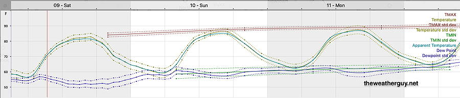
Here’s the updated model blend (NBM) forecast temperatures and humidity meteogram for Blue Bell, PA through Monday—
06z NBM forecast temperatures, dew points and apparent temperatures (heat index) for Blue Bell. Philadelphia temps run about 1.5-2º higher. (Click on image for a larger view.)
Posted Thursday 08/07/25 @ 5:18 PM — High pressure to our northeast remains in control of our weather through the weekend with easterly winds and near average temperatures.
The high pressure ridge that noses down from the northeast is blocking hotter and more humid temperatures from reaching the Philadelphia area—
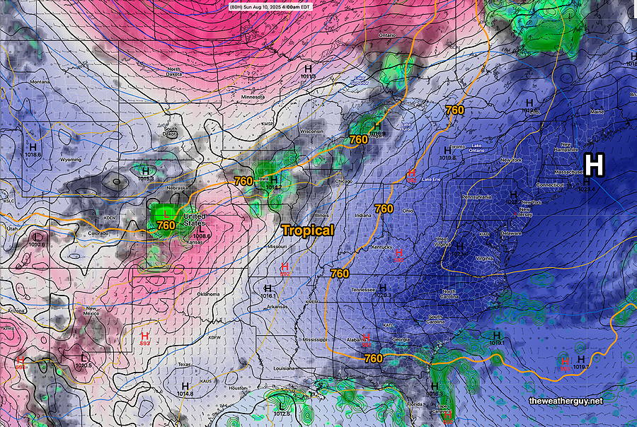
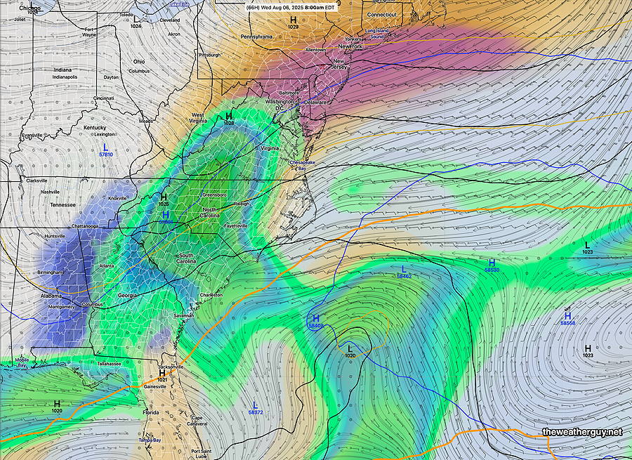
Canadian GDPS with “AI Spectral Nudging” captures the weather setup. High pressure (blue) is blocking moisture and heat from reaching our area. The 500-1000mb thickness line at 760 decimeters (orange) gives a three dimensional outline of the high pressure air mass. South and west of the 760 line (orange), it is very hot and humid. That 760 line might reach us by next Monday or Tuesday. (Click on image for a larger view.)
With sunny skies, the only change will be a gradual increase in temperatures through Sunday.
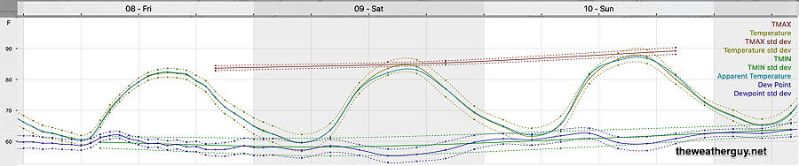
Today’s 18z NBM temperatures and dew point meteorgram for Blue Bell PA. Philadelphia runs 1-2º higher. (Click on image for a larger view.)
Thursday and Friday
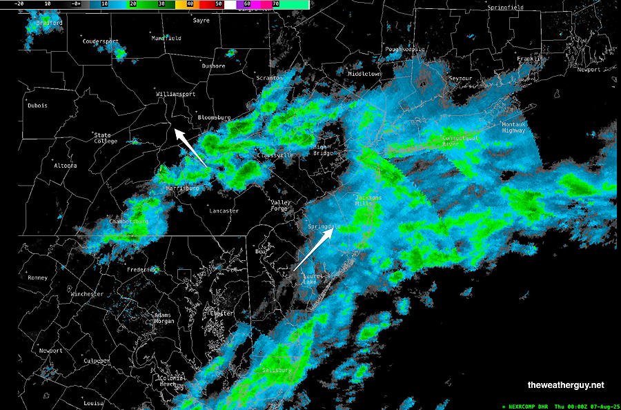
Posted Wednesday 08/06/25 @ 8:04 PM — We had the clouds and the smoke today. Showers broke out on schedule late this afternoon and current radar shows light activity outside of the immediate PHL area.
Radar Image 8 PM (Click on image for a larger view.)
For Thursday and Friday (and the weekend as well) clouds will diminish and both days will have mostly sunny skies. Highs in the low 80s and dew points similar to today, in the low 60s.
Blocking high pressure in the Atlantic will keep this pattern through the weekend, but expect a gradual increase in temperature and humidity, which will become apparent by Sunday. Things change early next week with more heat and humidity as the high pressure system breaks down and retreats.
Wednesday Forecast Change
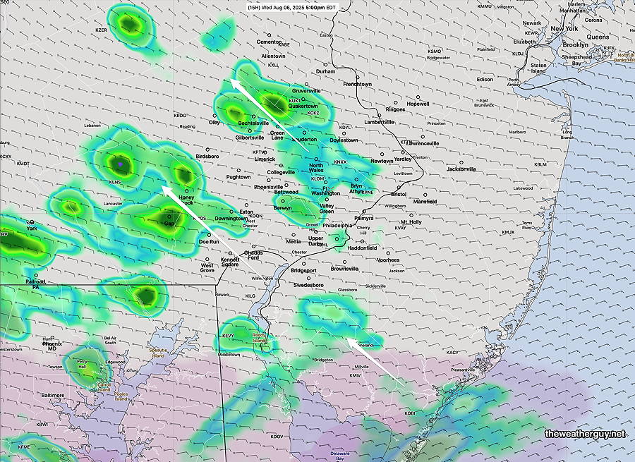
Posted Wednesday 08/06/25 @ 10:06 AM — As another test for the REFS model under development (and expected release in 2026), the latest REFS is a bit more emphatic about some shower activity Wednesday, late afternoon and evening. A past known model flaw has been an over-prediction of convective precipitation; we’ll see if this has been solved.
Today’s 06z REFS forecast at 5 PM (previous 1 hour rainfall) The showers will move northwestward instead of eastward. (Click on image for a larger view.)
Wednesday- Cloudy and Smokey
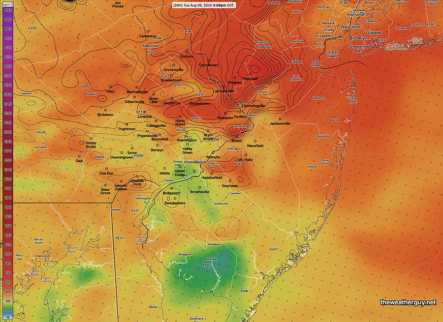
Posted Tuesday 08/05/25 @ 7:54 PM — High pressure to our northeast will keep an easterly flow over our area. Dew points remain in the low 60s, not “tropically humid” but not all that dry. Meanwhile, smoke will circulate into our area and will be noticeable.
18z HRRR smoke model forecast for Wednesday afternoon. Contours are low level smoke. (Click on image for a larger view.)
An area of moisture from a disturbance off the southeastern coast will move northward. A cloudy day with smoke. A few light, very widely scattered showers are possible Wednesday evening, most models have these showers to the west of Philadelphia, although the Canadian HRDPS has some showers near Philadelphia and into NJ.
Less cloudiness on Thursday, but a chance of a shower in the afternoon. No distinct sign of tropical development off the southeastern US.
Tuesday Update
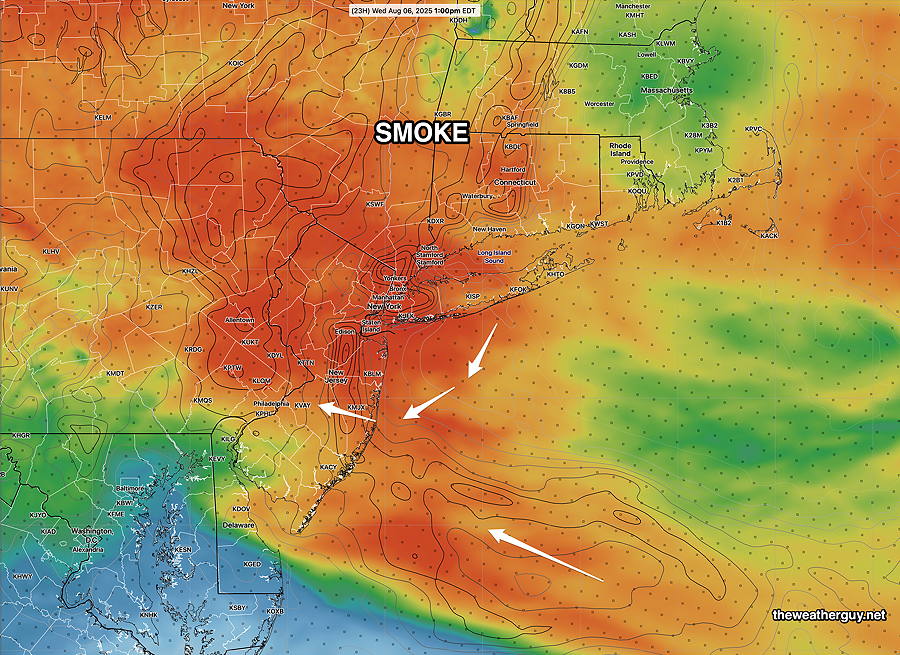
Posted Monday 08/04/25 @ 8:12 PM — Tuesday will likely have the most significant smoke at ground level that we’ve seen recently. On top of an increasing cloud cover, especially from the city southward, sunlight will appear dimmed.
18z HRRR smoke forecast near ground level around 4 PM. Smoke will be noticeable. (Click on image for a larger view.)
It appears that any rain from the southeastern coastal system will be suppressed to just south of the city late Wednesday into Thursday. Cape May county will likely see some showers.
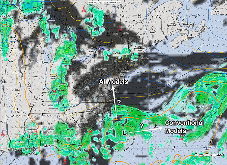
A diffuse area of unsettled weather off the southeastern US coast later in the week still not showing much sign of organization. The ECMWF was the most on-board for tropical like development, but the AI models keep the system disorganized.
Humidity remains relatively low through the end of the week moving just into the low 60s. That may change with any tropical development.
Monday Update
Posted Monday 08/04/25 @ 8:37 AM — The wildfire haze will likely decrease a bit over the daytime hours Monday, according to the HRRR-Smoke model.
As for the uncertainty regarding the storm and moisture along the southeastern US coast, the GFS-AI, ECMWF-AI and the Canadian GDPS with “AI Spectral Nudging” have high pressure suppressing the rain just to our south Thursday and Friday. No longer is there a distinct sign of tropical storm formation.
However, a fair amount of cloudiness is expected Tuesday and Wednesday due to moisture moving up aloft.
The GFS-AI maintains the furthest northern extent of the showers on Thursday; it’s likely too far northward—
00z GFS-Graphcast AI model forecast for Thursday. Likely too far north with its showers. (Click on image for a larger view.)
Originally Posted Sun 8:31 PM —Except for the smoke plume that may be with us at daybreak, Monday promises to be another very nice day with low dew points.
The forecast for the balance of the week is more uncertain than you might believe from the broadcast weather people.
There remains significant questions about a large disturbance along the southeastern US. Some of the moisture may move in as clouds as early as Tuesday afternoon.
There is even some question of potential tropical storm development in the same general area. The RRFS, German ICON and ECMWF-AI have some of the moisture moving up along the coast late Wednesday into Thursday. The period beyond Thursday is even more uncertain.
Here’s the latest ECMWF-AI model forecast for Wednesday morning, showing clouds and rain trying to move northward, but somewhat blocked by high pressure. How far that advances is still ‘up in the air’.
18z ECMWF-AI forecast for Wednesday morning. Maroon shading is mid level cloud cover. Rain is blocked from moving northward by high pressure in the northeast. (Click on image for a larger view.)
Posted Sunday 08/03/25 @ 9:54 AM — Another beautiful day expected today, but an increasing flow of smoke from Canadian wildfires will put an increasing layer of haze over us. Near ground smoke concentrations may reach levels that give the air a distinct wood fire smell; something that has occurred a few times since Friday.
By tonight into Monday morning, a smell of smoke should be apparent to sensitive noses—
12z HRRR smoke model forecast: vertically integrated smoke with smoke levels 8 m above ground. (Click on image for a larger view.)
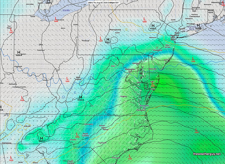
Blocking high pressure should keep low pressure suppressed to our south through at least late Wednesday. The forecasts diverge at that point, with the GFS-AI and the ECMWF-AI models bringing clouds and rain up the coast by Thursday, while the conventional numerical prediction models (GFS, ECMWF, GDPS) keep it suppressed to our south. The German ICON model is somewhat closer to the AI models.
This will be a good test for the AI models.
Today’s 06z GFS Forecast for Wednesday night. The AI models are very different, bringing the low pressure system inland and up the coast by Wednesday night A good test for the AI models. (Click on image for a larger view.)
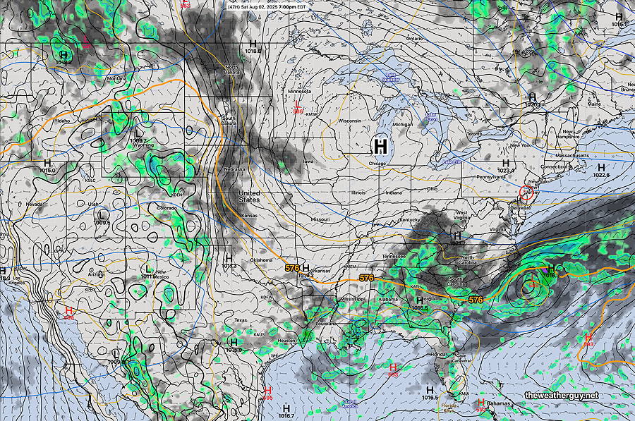
Originally Posted Fri 4:28 PM —Sprawling high pressure moves in for the weekend, as the heat and humidity is suppressed far to our south.
00z GDPS with “AI Spectral Nudging” forecast for Friday evening. Black-grey is cloud cover. Orange contour is the 576 thickness line (1000-500 mb thickness) The 576 line is a dividing line between tropical air and more pleasant temperatures and humidity A weak tropical system move out to our southeast. (Click on image for a larger view.)
Saturday Forecast
Sunny with light winds, becoming somewhat breezy after noontime.
NBM high temperatures: Blue Bell, PA 81 º Philadelphia, PA 82º Low Uncertainty (based on standard deviation): ± 0.9º
Sunday Forecast
Sunny, less windy
NBM high temperatures: Blue Bell, PA 84º Philadelphia, PA 85º Low Uncertainty High Confidence (based on standard deviation): ± 0.9º