
#Philadelphia #weather #PAwx #PhillyWx
Sunday Update
Posted Sunday 05/18/25 @ 9:21 AM — A beautiful day ahead with temperatures in the low to mid 70s, sunny skies and low humidity.
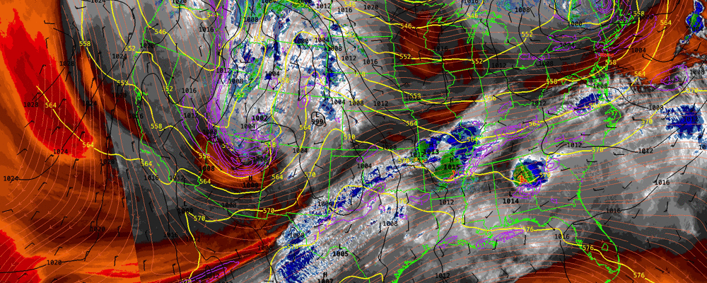
I’m keeping an eye on the upcoming weekend and the Memorial Day Weekend. Here’s the current water vapor satellite with radar and select RAP model parameters superimposed—
An unsettled period, late Tuesday night through Thursday with rain at times. Depending upon the exit of another cut off upper level low, things should improve by the Memorial Day Weekend, however, it’s looking rather chilly for May.
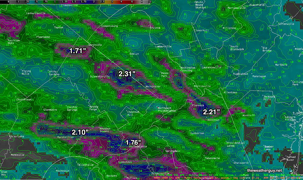
I also wanted to post the MRMS rainfall total for the heavy rains received this past Friday—
Saturday Update
Posted Saturday 05/17/25 @ 9:41 AM — The showers that developed (only forecast by some of last night’s 00z models) with the cold front this morning are moving through.
Sunshine should break out shortly. I wish the forecast for the rest of Saturday was clear cut, but it’s not. Several models have some scattered showers and thundershowers mid or later this afternoon. The latest HRRR which just became available keeps any scattered pop showers far west of our area. The Canadian HRDPS, which was correct about these showers this morning, still forecasts scattered light showers as late as 7 PM. We’ll have to see.
Posted Saturday 05/17/25 @7:35AM — I was off-duty last night but the models showed some light showers with this morning’s cold front.
Low pressure in Canada will move east and will drag a cold front across the area late Saturday morning. High pressure builds in for Sunday.
Saturday Forecast
Cloudy early morning. Clouds break for sun about 10 AM to noon. Somewhat breezy.
NBM high temperatures: Blue Bell, PA 83º Philadelphia, PA 86º
Sunday Forecast
Sunny and somewhat windy. Cooler.
NBM high temperatures: Blue Bell, PA 74º Philadelphia, PA 76º
Uncertainty (based on standard deviation): above average