
#Philadelphia #weather #PAwx
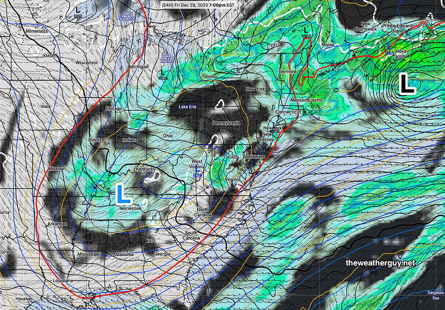
Some Sunshine on Friday
Posted Thursday 12/28 @ 5:41 PM — It appears that things will clear out enough on Friday that we’ll see some sun. Indeed, a fair amount of sunshine is expected on Friday. (Yes, this is a change in the forecast from yesterday, where clouds were going to remain.)
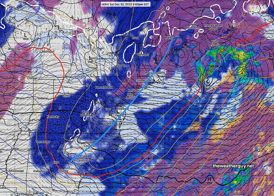
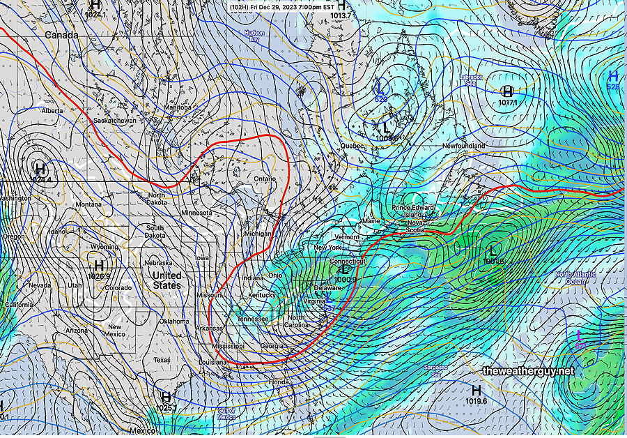
The upper trough moves over us on Saturday with a reappearance of clouds, at least for a part of the day—
A weather pattern change appears likely around January 4th through 6th. I’ve updated my Winter Outlook.
Tonight Through Friday
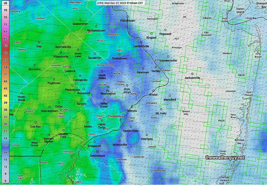
Posted Wednesday 12/27 @ 9:49 PM — The heavy rain expected really began in earnest about 8 PM. Some areas to our west have already had significant rainfall.
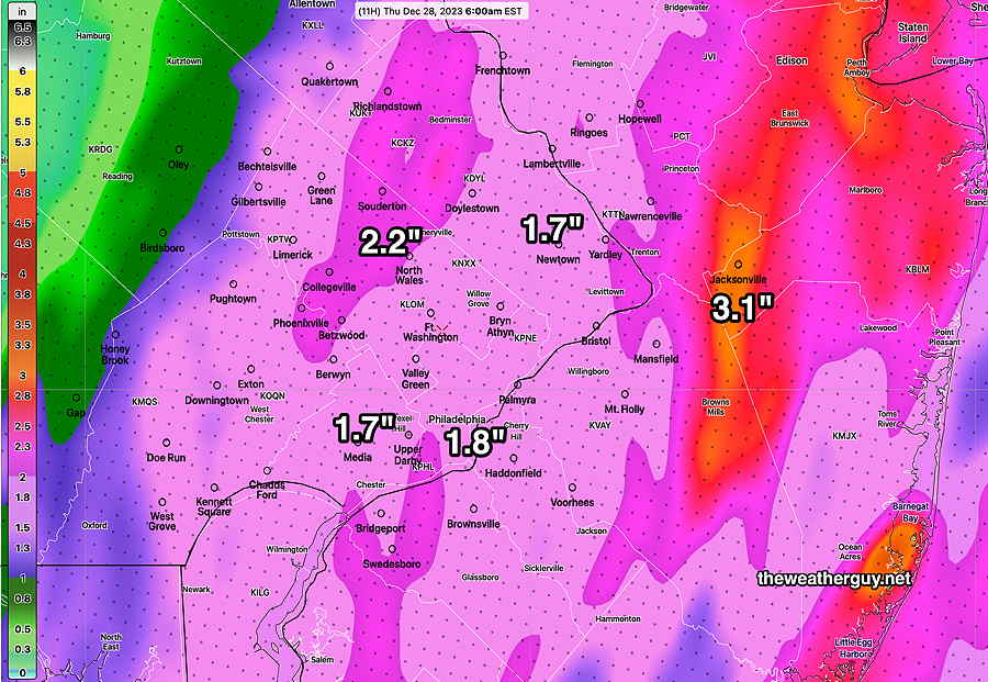
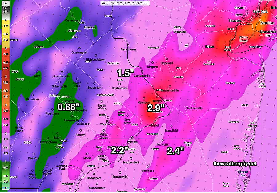
Here’s the current rainfall (MRMS measured) that fell through 9 PM—
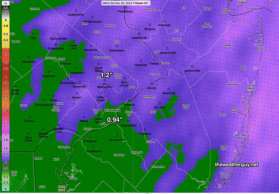
Here’s the additional rainfall expected from now through 6 AM, according to the latest HRRR—
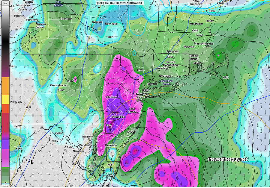
Posted Wednesday 12/27 @ 5:43 PM — Heavy rain and gusty winds are still expected, beginning this evening and tapering before daybreak Thursday. The rainfall totals are still in the general range as shown earlier.
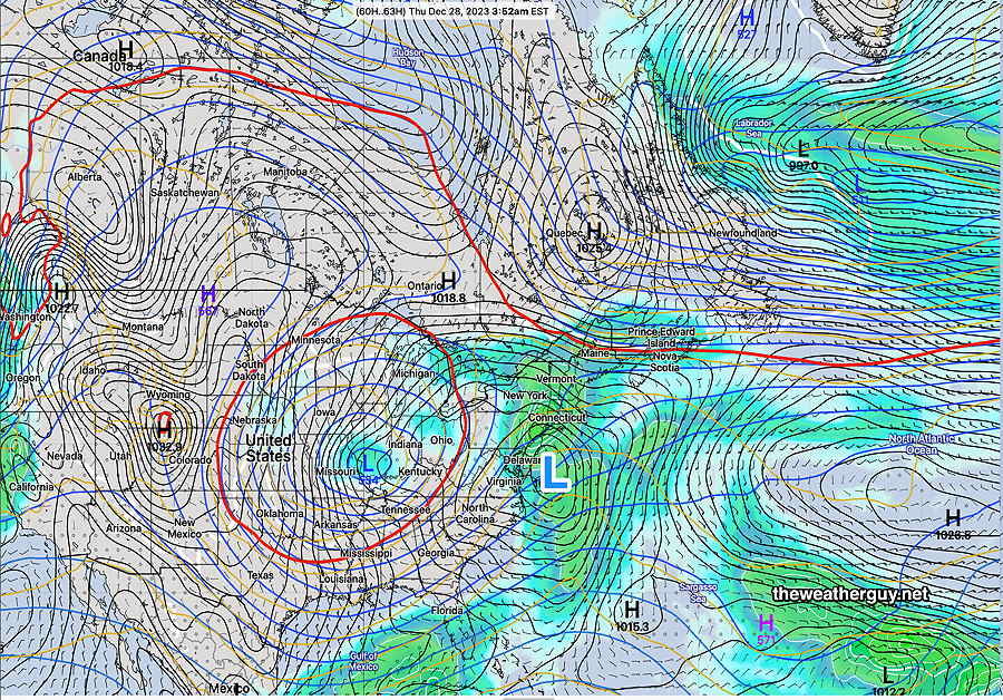
Ordinarily following a storm, clearing moves in, but that’s not the case with the current system. A large upper low is still to our west and clouds and intermittent light showers are possible Thursday and even Friday.
Whenever the early part a model forecast fails, it always puts the remainder of the forecast into a low confidence situation. So, we’ll have to proceed with this in mind for today and lean on the ECMWF. See the Wednesday Forecast Update below
Wednesday Forecast Update
Posted Wednesday 12/27 @ 8:09 AM — Relying on the ECMWF model, it continues to have a bullseye of heavy rain over the Philadelphia area by late evening —
The ECMWF shows rain throughout today of varying intensity, with greatest intensity this evening and overnight.
Total rainfall will be heavy, around 1.5-2″ with locally higher amounts—
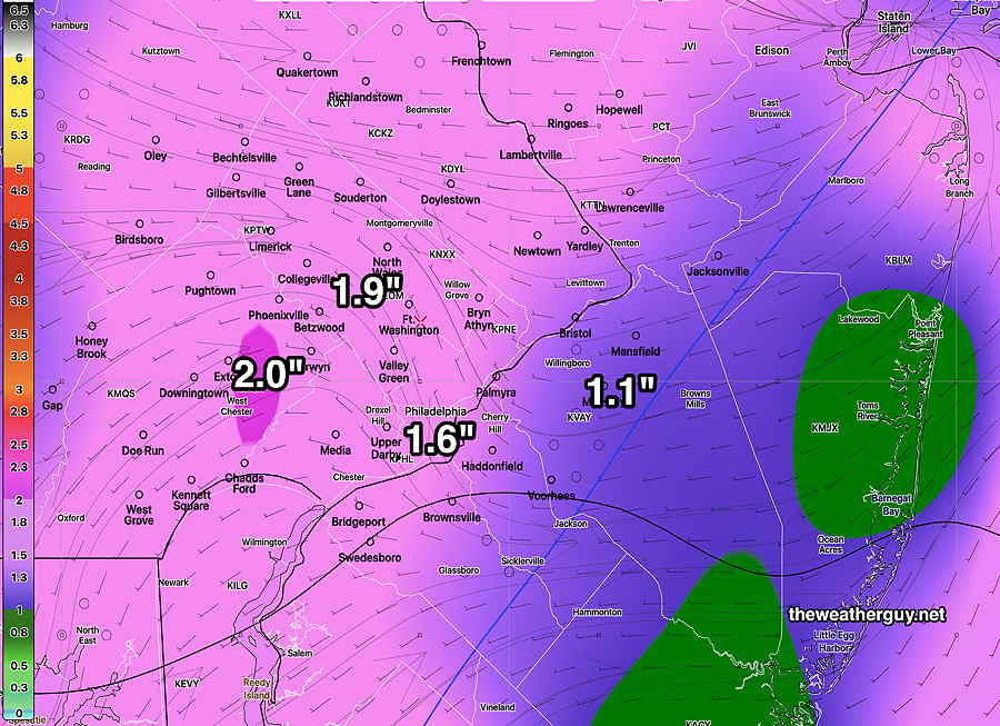
The ECMWF also has an area of showers that moves through as late as Thursday afternoon.
Heavy Rain Being Forecast… Again
Posted Tuesday 12/26 @9:09 PM — Tonight’s early models are delaying the heavy rain until Wednesday evening. Rainfall during the daytime will likely be light.
Posted Tuesday 12/26 @ 6:05 PM — It looks like the rain will move in from the west, beginning about 9-11 AM Wednesday morning.
Here’s the NBM blend showing ‘simulated radar’ at 11 AM—
Posted Tuesday 12/26 @ 5:06 PM —As posted this morning, a secondary low is expected to develop off the coast Wednesday. Monday night’s models were leaning towards a much more westward rainfall maxima, but today’s models (and the NBM- model blend) have maintained heavier rainfall in our area for Wednesday.
The latest 18z HREF, HRRR and NAM-NEST are showing fairly heavy rainfall—
I don’t know the exact hydrology situation in our area, but I think the rivers and streams are already on the full side from the heavy rains of about a week ago. If we get this level of rainfall, expect some more flooding.
Forecast Update
Posted Tuesday 12/26 @ 9:15 AM —Last weekend’s forecast had low pressure moving in from the west. Over the past day or so, the models are showing a secondary low will develop off of the coast—

With the secondary low formation, the energy of this system is expected to “jump” over us, possibly reducing the total rainfall in our area on Wednesday.
Several models have backed off considerably on the rainfall in our area, but the latest 12z NBM still shows about 1″ of rain (this may change) —
Additionally, rain that had been expected to begin Tuesday evening is now expected to begin Wednesday morning.
Additional rain possible on Friday.
Week Overview
A low pressure system in the nation’s mid section will move east and spawn a secondary coastal low on Wednesday—
Before that time, we’ll have cloudy conditions, with early fog on Tuesday. Then continued mild, highs 51-53º.
About 0.8 to 1.1″ of rain is expected from Tuesday evening (about 8 PM) through Wednesday.
Thursday will be another mild, transitional day. Windy!
Another coastal low is expected on Friday—
As mentioned in my recently updated Philadelphia Winter & Snow Outlook, a pattern change is strongly signaled for the first week in January— look for much colder and likely stormier weather towards the end of next week.