Updated Sun 08/06 @ 9:14 AM — A southerly to southeasterly flow of warmer and more humid air will affect our weather today.
A warm front is taking shape for Sunday night (after midnight) that will bring showers and thunderstorms between 1 AM and 6 AM. The warm front and cold front are easily visible on water vapor imagery.—
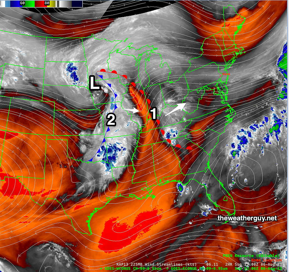
Satellite Water Vapor Image Sunday morning shows the warm front (1) and the cold front (2) that will affect our weather Sunday night (after midnight) and Monday evening. This water vapor image (channel 9) specifically looks at the temperatures of the mid and upper levels of the atmosphere; it does NOT capture reflected light from clouds. The orange areas are warmer. On Monday, we’ll be in the narrow area orange sandwiched be the warm front and cold front. (Click on image for a larger view.)
This is the sort of scenario where thunderstorm might wake you up tonight.
After a very humid and sultry day Monday, very strong thunderstorms are likely late afternoon into evening Monday. (5 PM through 10 PM)
Plenty of CAPE, instability and helicity will be present for some strong to severe storms with a slight-marginal tornadic possibility. Unlike the past two thunderstorm threats, this one does not look like it will fizzle out.
Stay tuned for updates.
Updated Sat 08/05 @ 5:54 PM — Today, we had clouds and sunshine through a significant shield of high level clouds. Some people might casually describe today as having been sunny, but meteorologically, it correctly goes down as ‘mostly cloudy’ in the official PHL airport record.
Sunday may start cloudy very early, but we’ll have more sunshine than today through high level clouds and there will be fewer mid level clouds. High temp 87º- Blue Bell, 88º-Philadelphia. Increased humidity.
Current Satellite WV image shows complex system in Midwest to approach Sunday night into Monday. (Click on image for a larger view.)
Clouds move in from an approaching system about 4-6 PM. Showers after midnight Sunday. Showers on Monday with a high chance of thunderstorms Monday evening. Dew points in the low 70s Monday!
Previously Posted Fri 8:16 PM —
Some strong showers and storms near Harrisburg this afternoon have been falling apart as they move east. A few light showers are still possible this evening into tonight in our area.
Weak high pressure builds in for the weekend, but the remnants of the front will not be very far southeast of us. Very weak waves of low pressure will develop on the boundary. A bit more high cloudiness at times is all that is expected. Another system approaches Sunday evening from the west bringing clouds late Sunday afternoon.
Saturday
Some cloudiness early, then becoming partly cloudy/partly sunny. Sunshine through considerable high cloudiness (cirrus) is expected due to moisture flowing back aloft from the circulations to our southeast.
Today’s 18zGFS shows weak surface level wind cyclonic flow and convergence along the weak frontal remnants to our south and east. May cause more cloudiness than currently forecast. (Click on image for a larger view.)
High temperature 84.8º sd 1.1º ( NBM model— location Blue Bell, PA)
Sunday
Periods of sun and clouds. (An easterly wind flow may bring more clouds than currently expected.)
High temperature 86.6º sd 1.6º ( NBM model— location Blue Bell, PA)