Tag Archives: NBM Text Products

WEEKEND WEATHER FORECAST

#Philadelphia #weather #PAwx #PhiladelphiaMarathon

Useful Link for the Model Blend (NBM) Data

Posted Saturday 11/23/24 @ 4:56 PM — The NBM is considered one of the best sources of hourly temperatures and winds and rainfall. The NWS has a link for obtaining this data in text format, albeit for local airports ( but not specific locations like Center City as I provided below.)

I’ve pre-configured the link for Philadelphia and Northeast Airports along with Wings Field in Blue Bell.

This link has been shared on this blog before, with explanations and examples to how it uses the GMT time zone (now called UTC or Coordinated Universal Time).

The hourly NBM labeled NBH is very useful once you get used to the GMT (Universal) time. (7AM here is the column labeled 12)

The extended (NBE, NBX) data is less intuitive, since as an example, next Thursday’s daytime data is shown in the column labeled 00z Friday (which occurs at 7 PM EST Thursday). You can find my NBM Text guide here.


Sunday Forecast Update

Posted Saturday 11/23/24 @ 12:06 PM — Latest NBM wind meteogram for grid point Center City Philadelphia and the marathon. Large uncertainty range (dotted lines) on wind gusts.

11-23-24 12z NBM wind meteogram for Center City (Click on image for a larger view.)

I’ve updated the regional rainfall totals map for the past 48 hours here.

Originally Posted Fri @ 6:52 PM — —The deep upper low and surface low exit our area late Friday night. Skies will clear for Saturday with high pressure building in. A weak warm front will bring a mix of clouds and sun Sunday. Clouds decrease during the mid afternoon. I’ve used the NBM data for Center City Philadelphia to cover the Marathons.

Saturday Forecast

Mostly sunny and a bit chilly and windy. We’ll still be under the influence of a cyclonic flow flow, but the GFS keeps us partly sunny.

11-22-24 18z GFS forecast for Saturday morning. The GFS keep us sunny but a cold windy flow will be noticeable. (Click on image for a larger view.)

Here’s the NBM wind/gust meteogram for Center City Saturday and Sunday—

NBM meteogram for grid point Center City Philadelphia (Click on image for a larger view.)

Sunday Forecast

A warm front will bring some clouds at times during the morning that will break mid afternoon. It will still be somewhat windy.

Here’s the NBM temperature meteogram for grid point Center City—

NBM Temperatures for Center City. (Click on image for a larger view.)

THIS WEEK’S WEATHER

#weather #paweather #wx #pawx #philadelphia #phillywx

Rex Block Takes Shape

Update Tue 04/11 @ 4:37 PM — We had a layer of high cirrus clouds move in today and they should move off to our northeast on Wednesday.

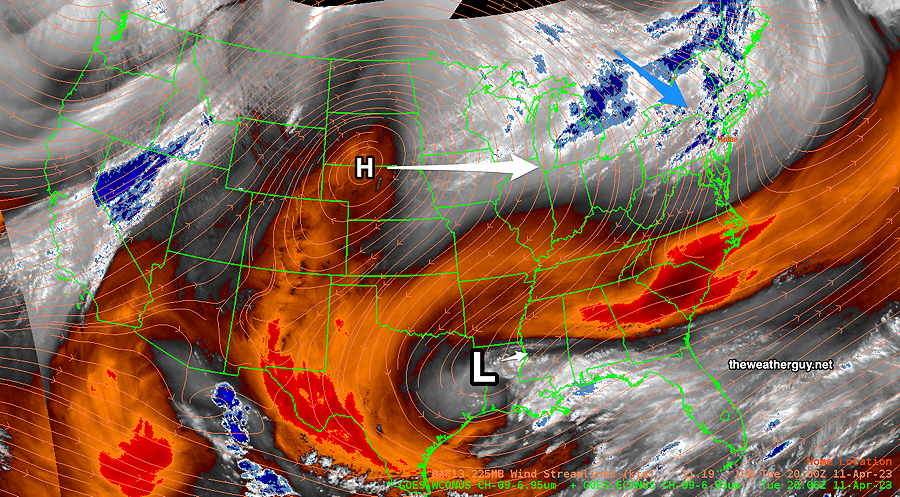
The Rex block is taking shape in the middle of the country. Here’s the current Water Vapor Satellite image —

Water Vapor mid level image at 4:30 PM. The high level cloudiness we saw today was from a disturbance to our north (Blue arrow) . This will move eastward. The upper level high (H) should become north of a closed off upper low (L) on Wednesday, forming a Rex Block. This will keep our weather delightful through late Friday. The upper low will slowly move up to the Carolinas on Saturday, affecting our weather. (Click on image for a larger view.)

Update Mon 04/10 @ 8:04 PM — Continued beautiful weather through Friday. Very warm but low humidity.

NBM High-low temperature forecast (see below for interpretation)—

NBM Text products Temperatures for Wings Field Blue Bell PA (KLOM) (Click on image for a larger view.)

A warm front moves through Saturday with some showers, clouds and an increase in humidity. A cold front moves through Sunday with thunderstorms.


Previously Posted Sun 5:06 PM —

“Rex Block” Will Keep Things Quiet This Week

A recognized upper air pattern for Spring (and Fall), is setting up for this coming week and it will keep our weather quiet for all of the week with increasingly warm temperatures.

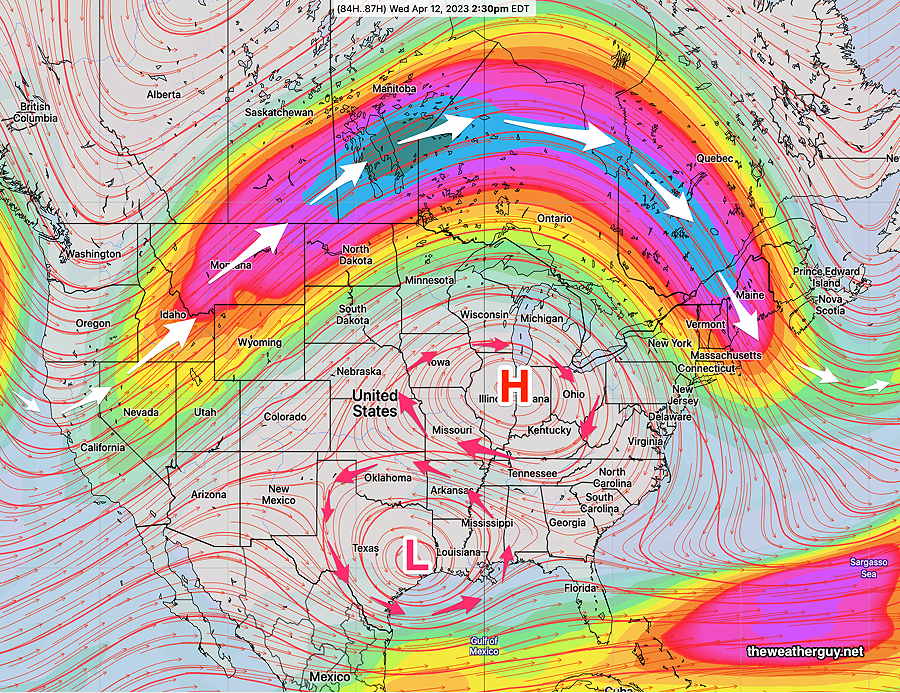
A “Rex Block” (named in the 1950s for a meteorologist, Daniel Rex) will develop in the middle of the country and the jet stream will be sending any disturbances far to our north. The Rex block, with an upper level high just north of an upper level low, tends to be a stable configuration and blocks any west to east movement of the usual dips in the jet stream.

Here’s the GEFS model forecast for Wednesday afternoon of winds at the 250 mb level (jet stream level). The upper circulation is notated with red arrows, while the main jet flow (white arrows) is well to our north—

This week’s GEFS jet stream wind forecast (250 mb level) for Wednesday afternoon. The Omega Block is shown- A stable upper levle configuration that blocks the usual progression of dips in the jet stream flow. We’ll be in the increasingly warm ridge for this week.
Temperatures- NBM Model Text Output Products

Here are the high/low temperatures expected this week from the NBM model. You can use this link to get your own data— NBM Model Text Output

The NBM model output text for KLOM (BLUE BELL) is a bit confusing unless you understand the meaning of the columns and how they define the high temperature period. TXN is the max and minimum temperature row. The HIGH temperature is is in the 00z column of each day. Example: For Tuesday’s high temperature— Since the high temperature is for the 12 hours preceding 00z on Wednesday, the 71º indicated on Wednesday’s 00 column really refers to TUESDAY’S HIGH TEMPERATURE. ( 00z Wednesday is at 8 PM EDT Tuesday evening . ) Similarly, the 82º high temp in the Friday 00 column is the high temperature for THURSDAY afternoon, since 00z Friday is at 8 PM EDT Thursday. Strictly speaking, it makes sense, but it isn’t at all intuitive. The XND is the standard deviation, rounded. The FHR is the Forecast Hour.