SNOW FOR SATURDAY?

A front moved through today, associated with a dip in the jetstream that will allow cold air to move in for the next few days.

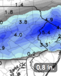
The frontal boundary stalled to our south and multiple models are showing the development of low pressure that will move along the front bringing significant precipitation.  Both the NAM and GFS show QPF values, as high as 0.98 inches of water.

There are currently differences between the timing and thermal profiles  of the models and those differences result in significant differences in the precipitation type (rain /sleet/snow).

The NAM is warmer and shows little snow until the afternoon.  The GFS is colder and faster, and shows as much as 4-6 inches of snow!

We also need to include consideration of sun angle in April and resultant solar insolation through clouds along with daytime vs nighttime Spring snows.   Too early to make a call, but interesting weather for April.  Stay tuned.

Wednesday 10:45 pm -Tonight’s NAM continues with a thermal profile that is too warm for snow during much of the storm around Philadelphia.

Upper Bucks and Montgomery County as well as western Chester county may have over 4 inches, as measured on grassy surfaces, but the immediate PHL area is mostly rain and some sleet, changing to snow late in the game.  A light coating possible.   Expect changes

SO WHAT’S WITH THIS COLD WEATHER?

People are asking me, what’s with this prolonged winter weather and cold?

One thing not talked about recently is the solar cycle.  We are about to enter a solar minimum.   The solar cycle is a regular, periodic change in sunspot number and the mimimum correlates with reduced total solar irradiance.

The solar cycle repeats ever 10-11 years.

The SORCE PROJECT has been measuring the total solar irradiance since 2003.

SORCE project total solar irradiance
SORCE Project Total Solar Irradiance

The previous solar minimum was in 2009.  The minimum has been shown to have a total solar irradiance that is reduced by about 0.5 -1 watt/m2.  Over the surface of the entire earth, that reduction adds up.

Maybe you’ll recall that the summers of 2009 and 2010 were usually cool?  I think the coming summers of 2018 and 2019 might be similarly cool.   (We’ll find out!)

So if it’s a cool summer, remember, it may be the sunspot cycle.

BTW, Here’s a link from my old blog in 2009 talking about the solar cycle.

Clarification 4-14-18: When I say cooler weather, it doesn’t mean we won’t have heat waves.  But it means that there will be fewer days in the 90s and average temperatures for the months of June July and August may be just below average.

PHILLY MONDAY SNOW FORECAST- SUNDAY NIGHT EDITION

The models continue with the scenario of low pressure moving along a stalled frontal boundary.

Reviewing today’s NAM and GFS data, the rain-snow critical thickness cuts right through Philadelphia.  QPF values are about 0.39 inches water.

Additionally, until precipitation gets going, it will take some time for dynamic cooling to establish a cold enough profile.  However the middle levels of the atmosphere will remain too warm for snow to form in much of Philadelphia, south and east.  

For most of Philadelphia, rain may mix with some sleet and maybe some rain snow mix after 4 AM, but should barely accumulate, even on grassy surfaces.  It should be wet, not white, in most of Philadelphia. 

Precipitation ends about 9 -10 AM.

For extreme Northeast Philadelphia, Chestnut Hill and areas of Montgomery County and Bucks County, 1/2 to 2 inches measured on grassy surfaces is possible, but even less on roadways.     The graphics below best depicts this snow accumulation potential—

Snow Forecast Philadelphia
NAM Snow forecast in inches for Monday 4/2/18  (ignore the 0.8 inset graphic)

Much of South Jersey will have no accumulation.   Temperatures rise in the morning and rapid melting will occur with whatever falls.


Weather… and Other Things 'Up in the Air'