This seems to be one of the dullest winter weather periods in recent years. As shown in last Friday’s forecast and graphic, the jet flow is flat due to cold air that doesn’t seem to want to make its plunge into the US.
For some time, the weather models haven’t shown any storm on the horizon for us, in contrast to last winter season, when the models showed numerous storms (but they were usually false alarms).
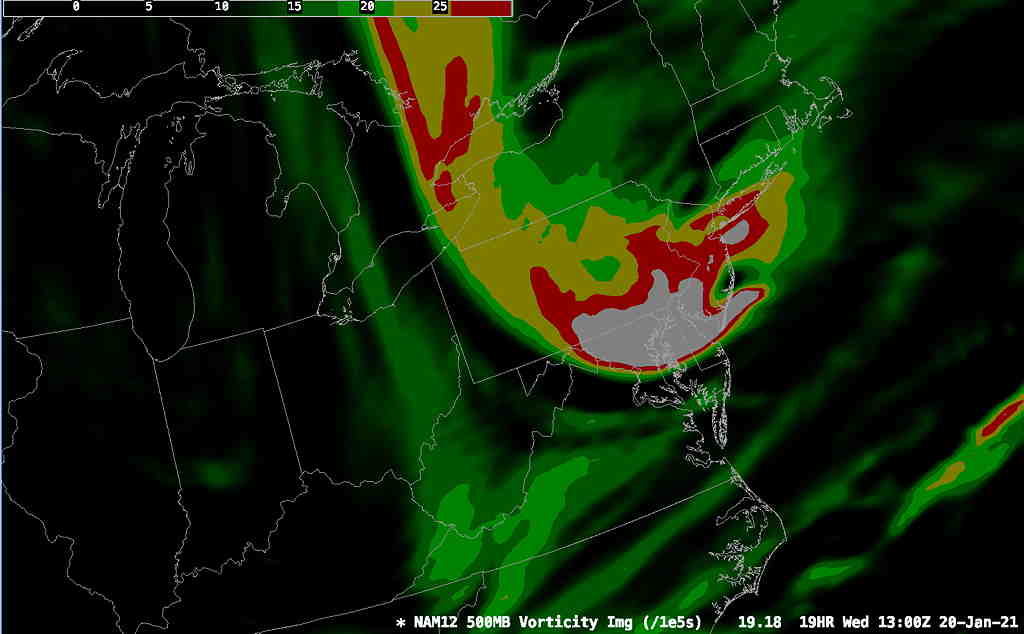
Nonetheless, an upper trough will swing through early tomorrow (Wednesday) morning. A strong area of vorticity is expected to pass through our area about 6-9 AM Wednesday. There will be enough moisture for snow flurries or snow showers around daybreak Wednesday morning and it will become quite windy after it moves through—
NAM model vorticity 8 AM Wednesday (Click on image for a larger view.)
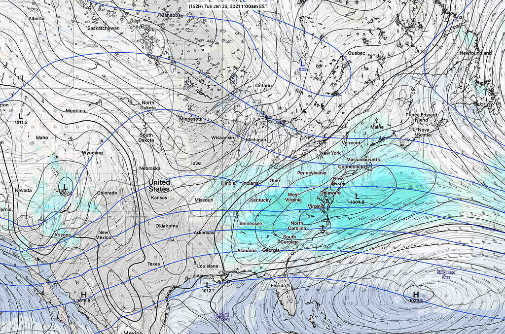
While there are no major storms on the immediate horizon, over the past several days, the statistical ensembleGEFS model has been showing a low pressure system moving by next Monday into Tuesday morning with maybe an inch of snow for us—
GEFS model forecast for Tuesday Jan 26th. (Click on image for a larger view.)
The models don’t show any coastal development of this low at this time. In the weather world, next Tuesday is a long ways off in the future.
Next week is also looking somewhat colder here and cold air is definitely building in Canada. Stay tuned.
I should preface this post by saying that I enjoy trying to predict snow rather than dealing with it after it has fallen. Pretty when it falls, a pain afterwards.
That said, I’m being asked, ‘ so where’s the snow?’
I’ve mentioned since the end of November that my sense of the weather pattern so far this winter is what I like to call “a lack of very cold air” to our north.
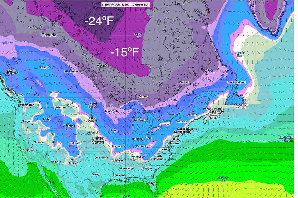
Here’s the current GFS statistical ensemble forecast (GEFS average) expected minimum temperatures for next week—
GEFS statistical average minimum temperature forecast for next Friday. (Click on image for a larger view.)
Well, maybe you’re thinking, -24ºF seems awfully cold to me? The truth is, when things get going, temperatures are as low as -40º to -50º in the same areas above, especially in Greenland. (Greenland is looking awfully warm this year.)
Contrary to what many weather entertainers on TV seem to suggest, the jet stream doesn’t just do it’s own, arbitrary thing. The jet stream, a fast flow of winds at about 35,000 to 40,000 feet in winter, is a river of air actually flowing in the three dimensional “valley” between air masses.
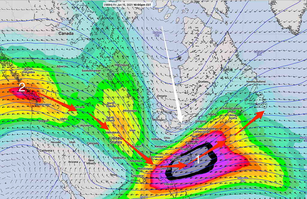
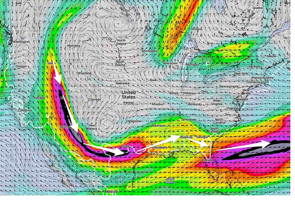
It is the density and shape of the cold air mass that determines the shape of the valley and of the jet, not the other way around. In essence, the jet flow shape in winter depends on the “sag” of very cold moving southward, as depicted below with the white line—
GEFS forecast Jet Flow (300 mb winds) next Friday (Click on image for a larger view.)
Notice that the white line is tilted slightly eastward instead of straight southward. The relatively “not so cold air” up north doesn’t have the mass density to dive straight south. The jet stream flow (red arrows) isn’t suppressed directly southward, but rather southeastward.
There also hasn’t been much of a blocking effect of a large cold air mass over Greenland and the Northern Atlantic to cause the same jet flow to bend back north up the coastline.
As a result the two “jet streak” impulses (numbers 1 and 2 above) develop low pressure systems, but these move out to sea.
So we need colder air in Canada, and colder air in Greenland and the North Atlantic.
The time period depicted above (January 15th-20th) does show some positive trends towards snow here:
Temperatures are colder in Canada than they’ve been.
The jet flow next week will be “less split” than it’s been. It does appear that some phasing may occur between the northern jet flow shown (disturbance #1 above) and the southern jet flow (just visible on the map from Mexico and near #1)
So, some colder temperatures and some action is possible January 15th – January 20th, although not currently captured on the models. Stay tuned
The current weather pattern forecast by all models, is for the jet wind flow to broadly stay far south of our area, preventing any disturbances from moving up the coast and keeping them moving out to sea.
Current model forecast for Sunday, showing jet stream wind flow (Click on image for a larger view.)
Several disturbances moving into the Pacific northwest US will follow this path. (The northern jet flow is so far north, it doesn’t show in this map!) Until things change, expect near seasonable temperatures and no snowstorms in our neck of the woods.
The medium and extended range models maintain this general pattern for the first two weeks of January. A change in the pattern may occur sometime around the 15th to the 20th of the month, when an arctic outbreak may shake things up. Of course, things can always change sooner, but this is the current model outlook.