#Philadelphia #weather #PAwx
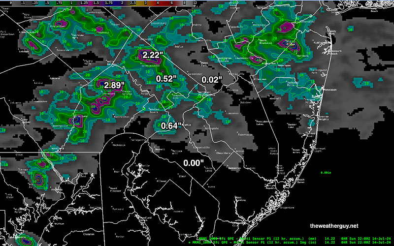
Posted Sunday 07/14/24 @ 11:35 AM —
Some of this morning’s models are showing an increased possibility of isolated severe thunderstorms. Not all areas will have a thunderstorm. The time window has increased from 3 PM to 9 PM.
Posted Sunday 07/14/24 @ 8:02 AM —
Several ingredients are coming together Sunday afternoon that will result in thunderstorms in our area, especially from Philadelphia and eastward. An upper trough, and thermal instability with high moisture will allow thunderstorms to develop from Lehigh county in the early afternoon to the Philadelphia area eastward into central NJ between 4 an 6 PM. Some scattered activity is possible through 8 to 9 PM.
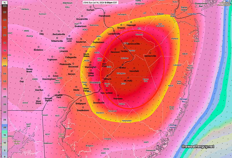
While heavy rain and gusty winds can occur with most thunderstorms, these storms can be strong, but not necessarily ‘severe’.
Posted Saturday 07/13/24 @ 9:50 PM —
A weak upper air trough will move through late Sunday afternoon, triggering scattered thunderstorms in the Philadelphia area. Peak probability is 4 PM-6 PM. A few may be strong. Look for an update Sunday morning.
Incredibly, every model, including those run at 00z (8PM EDT) and become available hours later (often after 11:30 PM EDT) continued to show heavy rain for the early morning hours in the immediate Philadelphia area.
Here’s the rainfall that fell over the past 12 hours, from 8 PM to 8 AM—
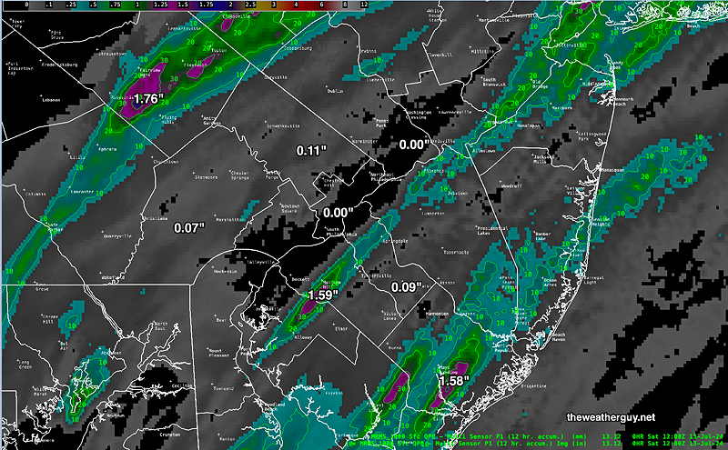
Clearly, the precipitation actually received doesn’t really approach any of the model forecasts posted yesterday.
So what could cause so many different models to be so wrong? This precipitation originated from a moist flow around high pressure in the Atlantic. There are relatively few direct measurements of pressure, moisture and temperature, especially vertically into the middle and upper atmosphere, in that region.
While new satellite techniques are used to infer and indirectly measure this some of this missing data, clearly there were errors and missing information. So the input conditions, especially in the middle and upper atmosphere were incomplete causing the model “initialization” to be wrong.
While numeric weather prediction has come an incredibly long way in the past 50 years, it simply can’t compensate for wrong or missing initial conditions. Can machine learning and AI, take it to a new level? I’m a little skeptical, especially with missing input information. I guess we’ll see.
Previously Posted Fri 5:50 PM —As posted earlier today, the heavy rain expected in the Philadelphia area did not materialize as forecast, but the heavy rain developed near the eastern shore of NJ (see here) with some extremely heavy downpours.
The latest model blend (NBM ) still shows significant rain for the immediate Delaware Valley, mostly occurring late Friday night into the morning hours on Saturday—
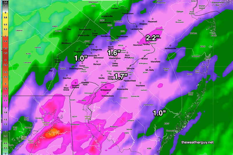
With the Friday forecast such a bust, I’d say this is a low confidence forecast. Nonetheless, the NBM is supported by the latest HREF which just became available.
On the other hand, the latest Canadian RGEM, also just available, shows a heavy axis shifted eastward-
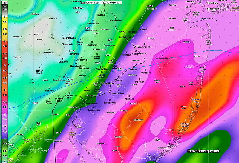
I’m leaning towards the RGEM, but who knows? 🙂
Saturday
Rain through the morning, ending from west to east, noon through 2 PM in the Delaware Valley, and as late as 5 PM at the shore. Some sunshine is likely here in the afternoon. Very humid!
NBM high temperatures: Blue Bell, PA 87º Philadelphia, PA 88º
uncertainty (based on standard deviation): ± 2.3º (higher than average)
Sunday
Mostly sunny, hot and humid. Heat indices near 100º
NBM high temperatures: Blue Bell, PA 93º Philadelphia, PA 94º
Uncertainty (based on standard deviation): ± 1.9 (average uncertainty)
