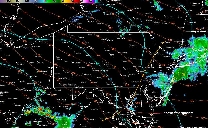
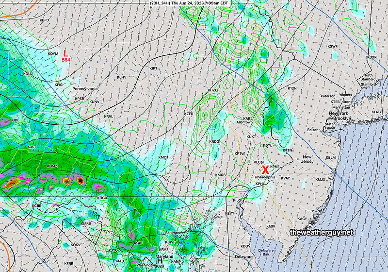
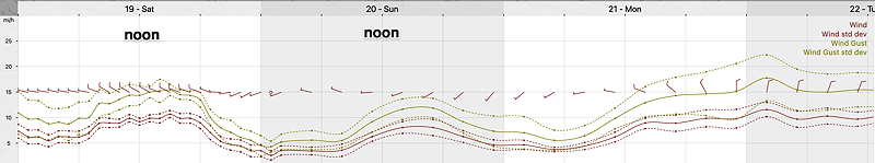
Updated Fri 08/25 @ 10:31 AM — The front moved though this morning.
This morning’s radar and RAP model overlay shows the showers have moved off. The lingering mid-level trough (dashed orange line) will move east and we’ll likely see a mix of sun and clouds for the rest of the day.
Last night’s forecast still holds:
Following the front, It will become quite humid with dew points in the low 70s by noontime. Some sunshine may break through late morning and early afternoon, but scattered showers are possible any time during the mid to late afternoon.
The only thing to add: Many of this morning’s models have little in the way of additional showers today. Additional showers, if any, will be widely scattered and most likely late afternoon or evening.
Friday’s Forecast
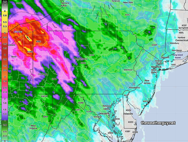
Updated Thu 08/24 @ 7:33 PM — A warm front will move through during Friday’s early morning hours (2 AM- 8 AM) with showers and thunderstorms. CAPE values are low, so no severe weather expected. However PWAT values are in the high (2.1″ to 2.2) range so some locally heavy downpours are possible, especially 5 AM to 7 AM.
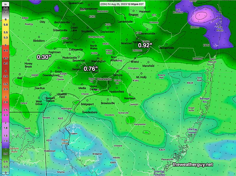
Today’s 18z HREF accumulated rainfall forecast through noon on Friday. (Click on image for a larger view.)
Following the front, It will become quite humid with dew points in the low 70s by noontime. Some sunshine may break through late morning and early afternoon, but scattered showers are possible any time during the mid to late afternoon.
A cold front moves through Friday night with scattered showers. The cold front looks to be slow moving and not distinct. Only scattered showers or thundershowers expected at this time, but that may change.
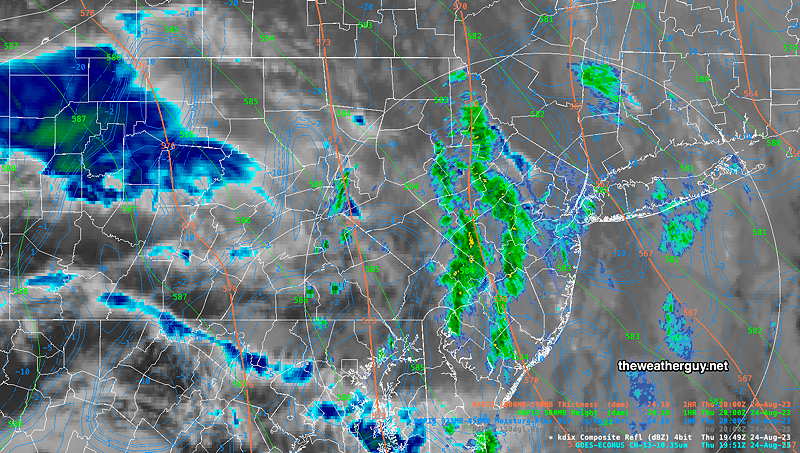
Thu 4:22 PM Forecast Review — This morning’s forecast went as predicted, but the heavier band of showers moving through this afternoon wasn’t predicted by last night’s models.
Current Radar at 4 PM shows bands of rain not predicted. (Click on image for a larger view.)
Over the next few days, we’ll likely see that this won’t be the only forecast that goes astray.
As mentioned earlier this week “These sort of situations with stalled fronts and moisture moving over a ridge are difficult to forecast accurately. Small movements of the boundary will cause large differences in the amount of rain any area receives.”
We have the additional complications of a tropical system in the western Atlantic and a potential tropical disturbance developing off of the western Florida coast. For reasons I don’t understand (and my research has turned up empty), tropical systems in the picture seem to play havoc with model forecast accuracy.
Thursday Forecast
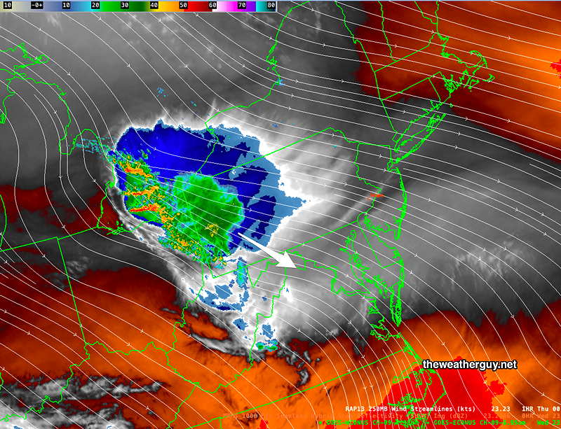
Updated Wed 08/23 @ 7:53 PM — A disturbance in the upper flow still appears to move mostly to our south and west tonight, along with the significant rainfall—
Water Vapor image with radar and RAP jet stream level wind streams (Click on image for a larger view.)
It will be mostly cloudy on Thursday with light showers mostly in the morning hours. Total rainfall through Thursday will be very light, especially from Philadelphia eastward, according to the HREF—
HREF total rainfall through Thursday at 8 PM. (The HRDPS has even lower amounts of rainfall from Philadelphia eastward.) (Click on image for a larger view.)
(Even lower rainfall amounts tonight and Thursday morning, according to the HRDPS.)
Rainfall from an approaching warm front Thursday night into Friday morning will likely be more substantial.
Wednesday Forecast Update
Updated Wed 08/23 @ 10:45 AM — The period from late Wednesday throughThursday is looking much less rainy than the HREF had forecast. Indeed, the HRRR and other models have moved towards the HRDPS which has been forecasting little in the way of rain here. (Showers move to our south and any showers moving towards us dissipate.) That’s why I began this week’s weather blog with “Unfavorable Pattern for Rain”
This morning’s 12z HRRR has joined the HRDPS in forecasting most of the significant rain will move to our south and north. (Some very light showers are still possible later tonight near the city. ) More significant showers possible Thursday night as a warm front moves northward. (Click on image for a larger view.)
Wednesday Forecast
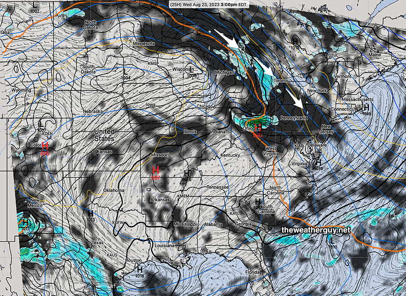
Updated Tue 08/22 @ 8:36 PM — The cold front moved through early today and Tuesday was delightful. The frontal boundary has hit metaphorical wall and has advanced southward as far as the heat dome will allow. The boundary is pseudo stationary and impulses traveling over the top of the dome (as shown in yesterday’s graphic) will begin to affect our weather Wednesday.
Some of the moisture, possibly from Hillary, will advance over us with considerable cloud cover on Wednesday—
NAM forecast for Wednesday 3 PM shows clouds (dark) and rain advancing towards us over the heat dome. The wavy orange line (thickness line) is the approximate boundary of the hot/humid air. (Click on image for a larger view.)
These sort of situations with stalled fronts and moisture moving over a ridge are difficult to forecast accurately. Small movements of the boundary will cause large differences in the amount of rain any area receives.
Currently, our HREF model forecast is for rain moving in around late evening Wednesday and continuing through at least Thursday morning and possibly on and off through much of Thursday. Interestingly, the latest HRDPS has the rain totally missing our area and moving to our south.
I expect the Thursday through Friday forecast to have higher an average uncertainty, low confidence.
A Cold Front Pushes Heat Dome to our South
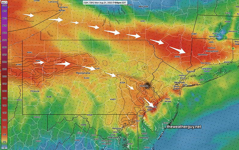
Updated Mon 08/21 @ 7:45 PM —We didn’t get as warm or as humid today as had been forecast, probably due to the layer of smoke in the atmosphere. (High in Philadelphia was 90º. Dew Points were in the mid 60s. Blue Bell on reached 86º.)
The heat dome is impressive on satellite imagery—
Water Vapor image shows the remnants of Hillary rotating around the large upper high pressure systems (heat dome) in the center of the country. The system in the Gulf is somewhat visible and the upper air support for the tropical system in the western Atlantic is also visible. (Click on image for a larger view.)
A sort of back door cold front (pushing in from the northeast) will suppress the heat dome to our south on Tuesday. Clouds in the morning Tuesday should break for partly to mostly sunny skies and cooler temperatures. Winds will shift to the NNE.
Several new things on the horizon—
Moisture rotating around the heat dome may bring us some showers Thursday into Friday.
A tropical system in the Gulf of Mexico will move westward, away from us, around the heat dome.
A tropical system looks like it will form in the western Atlantic somewhat near the Southeastern US. The path of this system is unknown at this time; it will likely remain offshore, but it may indirectly affect the Jersey shore within the week as its path bends north and northeastward.
Some of that Haze Monday is Smoke
Updated Mon 08/21 @ 9:16 AM — Today, some of that hazy sky isn’t only high cirrus clouds. It’s smoke and particulates, traveling across country over the northern edge of the ‘heat dome’ from Washington State Oregon and Canada. The haze/smoke layer is expected to thicken here about 4 PM—
HRRR smoke forecast for 4 PM today. Contours are low level smoke. (Click on image for a larger view.)
Hot, hazy and humid today. The smoke could shave off a degree from the expected high temperature. 91º to 93º still expected.
Unfavorable Pattern for Rain
We’ve moved into an unfavorable pattern for any rain, at least through Thursday.
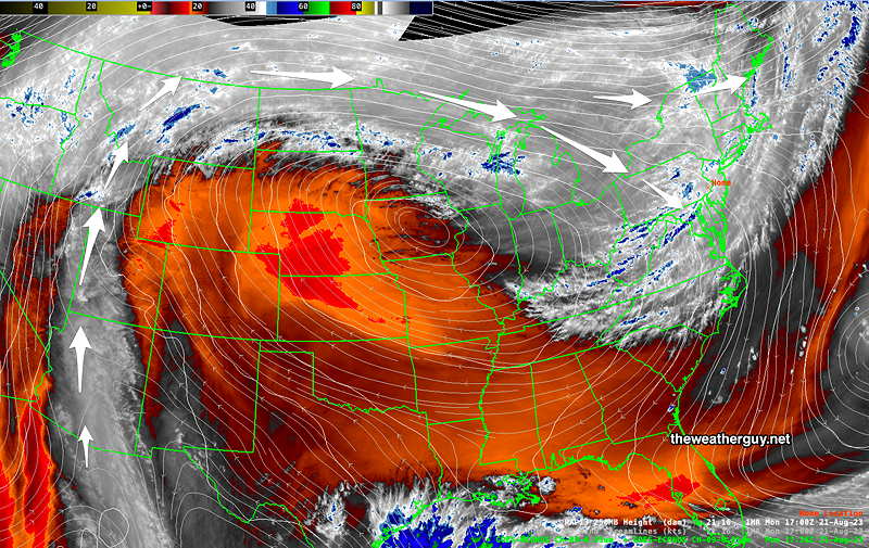
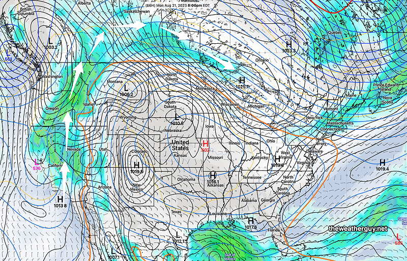
We’re still under a northwest cyclonic flow of drier air moving over the northern edge of the ‘heat dome’ that’s in the Central US—
GEFS forecast for Monday evening. The general flow is from the northwest around the heat dome (white arrows). While a cold front will move through late Monday night, we’re again in an unfavorable region of a jet streak for rain. Little if any rainfall is expected with this cold front. Note the orange “thickness line” which denotes the edge of tropical air around the heat dome. It just moves through our area on Monday, only to be pushed back southwest. (Click on image for a larger view.)
The remnants of Hillary may bring much needed rain to NW parts of Canada as it flows due north and then bends towards us. We may see some of that moisture towards the end of this week.
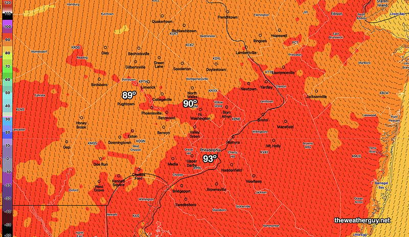
Monday will be hot here with highs 90-93º—
NBM high temperatures Monday (standard deviation is 1.4º) (Click on image for a larger view.)
This weekend’s forecast has been unchanged for most of this past week. Sunny and delightful with increasing temperatures by Sunday.
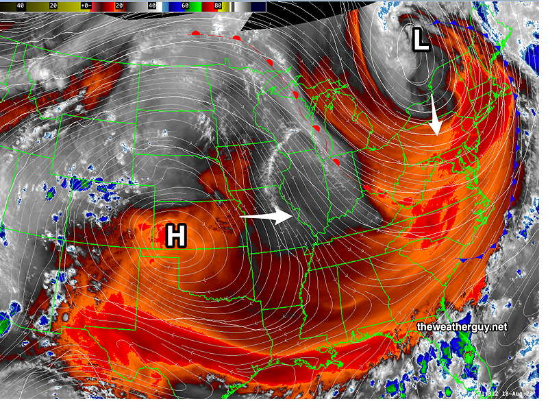
The heat dome in the middle of the country will be kept mostly at bay by upper low pressure in eastern Canada, although some heat will move in for Monday and part of Tuesday —
Satellite Water Vapor imagery shows heat dome (H) over Kansas and upper low over eastern Canada. The heat dome will try to move eastward Sunday through Monday, but the upper low in Canada will rotate a cold front across our area sometime on Tuesday. (Click on image for a larger view.)
Saturday
Sunny and delightful. Breezy.
High temperature 79º ( NBM model— location Blue Bell, PA) High temperature 81º ( NBM model— location Philadelphia, PA)
Sunday
Sunny and warmer.
High temperature 87º ( NBM model— location Blue Bell, PA) High temperature 89º ( NBM model— location Philadelphia, PA)
Update Thu 8/17 11:06 PM — Despite the jet streak explanation below (supported by tonight’s HRRR), tonight’s HIRESW closely matches current radar. It has a line of showers moving through around 5 AM Friday morning with some gusty winds.
Updated Thu 08/17 @ 5:32 PM —A cold front will move through about 4 AM -7 AM Friday morning.
As showers with this front approach from the north and west, they are expected to reduce in intensity or even fall apart as they approach the city and move into NJ.
Why will they reduce in intensity? We’ll be in the ‘left entrance region’ of a jet streak, which has descending motion—
ECMWF jet stream wind forecast for early Friday morning shows the Philadelphia area will be what’s referred to as the “left entrance region” of a jet streak (white box area) , associated with descending motion aloft and unfavorable for precipitation. (Ascending motion is needed for showers.) (Click on image for a larger view.)
Clouds clear during the morning and it will be sunny by afternoon. It will become WINDY. Highs 81º Blue Bell, 84º Philadelphia.
After another delightful day on Saturday, the heat dome affecting the central US will attempt to move into our area for Sunday.
Next week will have several unsettled days as disturbances move around the heat dome affecting our area. Several models are hinting at the beginnings of several tropical storms.
Thursday Forecast & Outlook
Updated Thu 08/17 @ 8:35 AM —Another sunny day! (A few pop up thundershowers possible about 4-6 PM. Most places will not see anything.) Another front will move through tonight (Thursday night) into Friday morning. Some showers and thunderstorms are expected to develop ahead of this front around daybreak Friday, but the models have them losing intensity as they approach the I-95 corridor. Clearing Friday for a very nice weekend.
This summer’s “heat dome” has moved eastward and is now expected to affect the central US. We’ll again be protected from the heat by a cyclonic flow from Canada.
The temperatures in the Central US will be intense by Sunday and Monday—
GEFS forecast for Monday. These are actual forecast high temps, not heat indices. (Click on image for a larger view.)
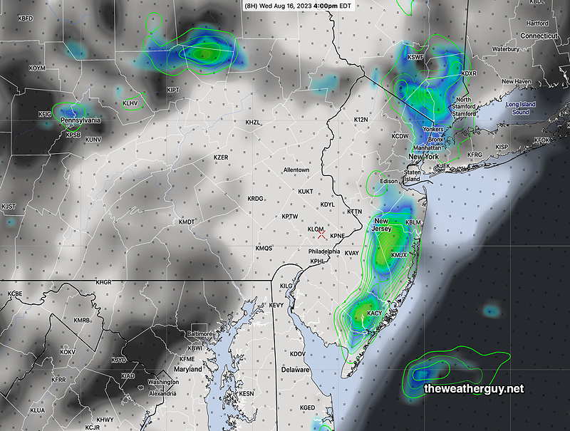
Updated Wed 08/16 @ 10:25 AM — The front that slowly passed through last night is lingering off of the coastline. Moisture will continue to move up along this front, affecting central NJ and the Jersey shore this afternoon. From Philadelphia westward, we’ll have partly to mostly sunny conditions. (Some of the HIRESW models have some widely scattered popup showers in our area, but these models can often overdo this.) See the image caption below for more details.
06zGFS forecast for Wednesday. Moisture continues to move northward along the coast near the stalled frontal boundary, affecting NJ today as high pressure builds in from the west. Notice the orange ‘thickness line ‘that winds down near Georgia and Arkansas and then up near Wisconsin. This is the boundary of the “heat dome” that will move closer to our area by Sunday and Monday. Before that time, a sharpening upper level trough will swing a cold front through here later Thursday through early Friday. (Click on image for a larger view.)Today’s NAM-NEST shows showers at 4 PM (Click on image for a larger view.)
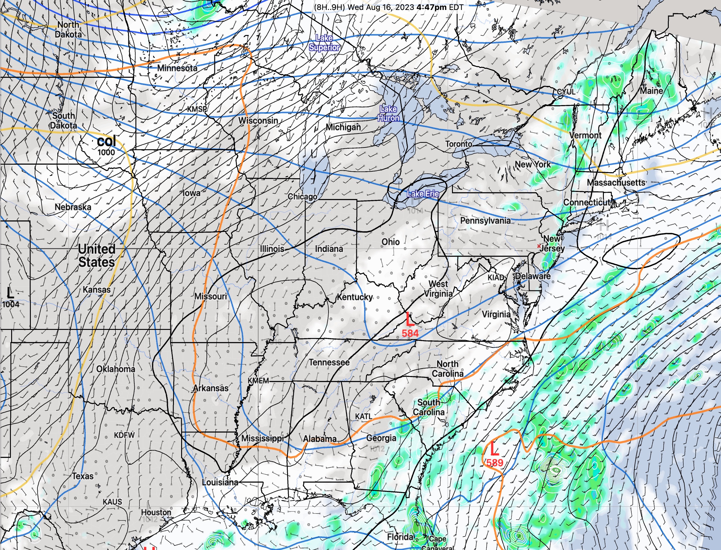
Tuesday
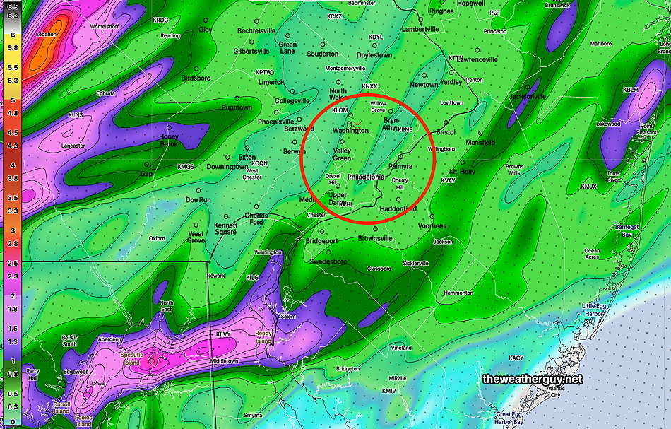
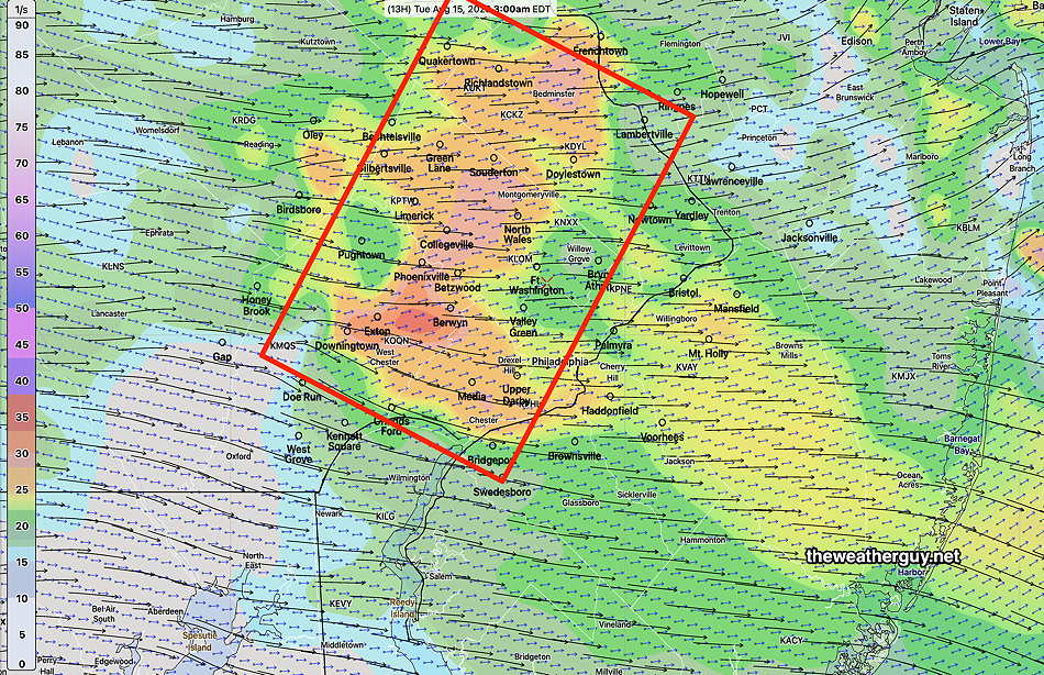
Updated Tue 08/15 @ 9:20 AM — We’ll try again for today’s forecast. A cold front moves through later this afternoon. CAPE values are more elevated today than yesterday. The HRRR shows showers and thunderstorms forming in a line from Philadelphia and moving into NJ. (The HRDPS has the line forming a bit further eastward, excluding the immediate Philadelphia area.) PWAT is still in the 2 inch range, so some quick heavy downpours possible. Current time frame is about 4-6 PM near Philadelphia and then moving through Southern NJ.
06z HRRR shows hourly Precipitation rate and cloud cover at 6 PM. (Click on image for a larger view.)
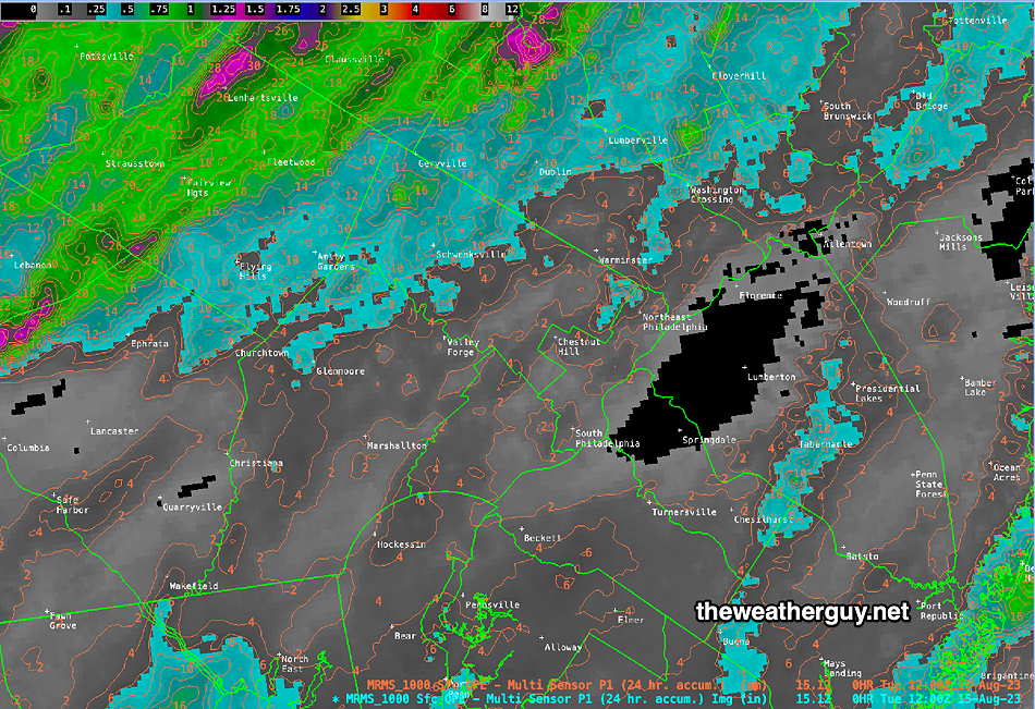
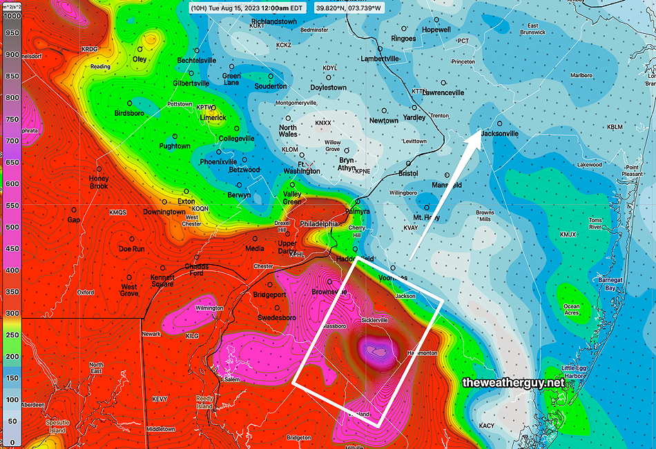
Tue 9:07 AM Forecast Review — As suspected last night, the forecast for heavy rain last was a bust. Very little rain, certainly not heavy rain, fell across the Philadelphia region. Here’s the MRMS estimate of the rainfall we received—
MRMS rain-gauge/radar estimate of last night’s rainfall. Few areas received even 0.25 inches of rain. (Click on image for a larger view.)
The missing ingredient was elevated CAPE in our area, specifically something called ‘surface CAPE’.
As mentioned, the model guidance had shifted away from the heavy rainfall forecast during the afternoon model runs and had clearly shifted away (with the exception of the HRDPS and a few others) in the evening model runs. With other parameters elevated, it was difficult not to leave the original heavy rain forecast intact. That’s my excuse. I can’t account for the TV/radio forecasts that were still pushing the severe forecast at 11 PM.
Monday Storm Update
Update Mon 8/14 11:48 PM —Tonight’s HRDPS, just available, shows some intense storms developing across the immediate Philadelphia area about 3AM.
Updated Mon 08/14 @ 8:46 PM — As highlighted in my previous update, the immediate Philadelphia area may escape heavy rainfall and severe weather.
The latest HRRR and RAP model runs (these models come out hourly) are conspicuously missing any heavy rainfall and severe weather signatures in our area.
I could be fooled by something called ‘model spin-up’ errors. Spin-up errors occur because models take time to approximate a realistic forecast, often several hours. Since the event is occurring imminently, the heavy rain and severe weather signatures may not be showing with the latest models. (But what is also perplexing is the lack of activity on radar and satellite, except in central PA. Will that move eastward or more likely northeastward, missing us?)
It is possible the severe weather forecast for regions just outside of the immediate Philadelphia area tonight is a bust. I guess we’ll know tomorrow.
Monday Storm Potential Update
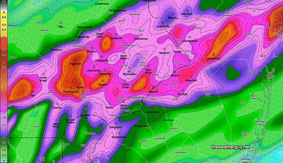
Revised Update Mon 08/14 @ 7:08 PM — Showers and thunderstorms will move in about 9 8 PM.
Today’s models continue with very high PWAT (2.3″ to 2.4″) and moderately elevated CAPE. Heavy rain potential (localized) is likely in in our area; Severe weather may occur later, after midnight, in some locations (see below). The immediate Philadelphia area seems to escape the heavy rainand maybe the severe weather.
Areas to our west, immediate south and immediate east may have the stronger to severe storms.
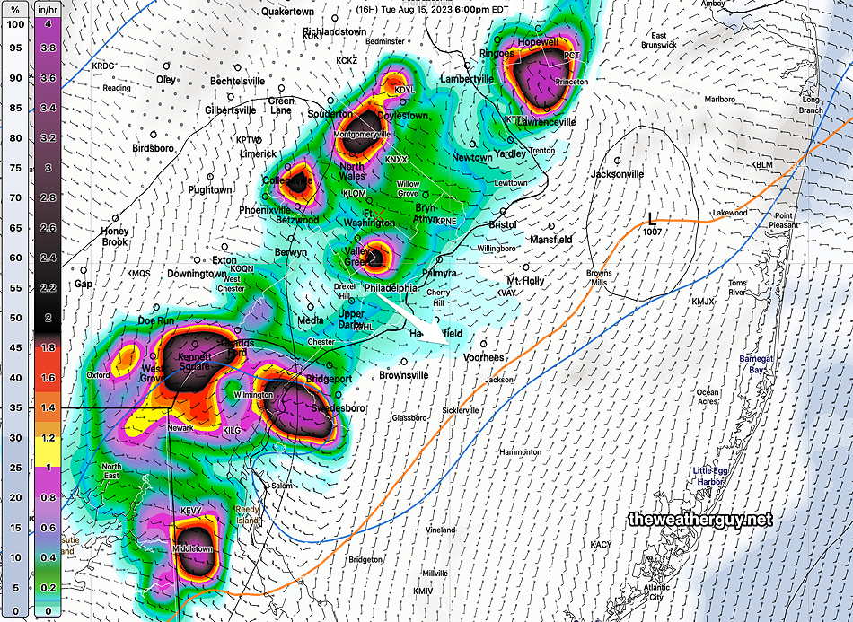
The HRRR model total rainfall this evening gives an idea of where the most significant storms will be—
Today’s 18z HRRR showing total rainfall prediction for this evening. Red Circle is Philadelphia, not in an area of likely severe storms. Delaware remains an area of likely significant heavy rainfall. Most models show this fork in the precipitation. Unfortunately, we’ve seen that the models are limited when it comes to accurately predicting the exact locations of heavy rainfall.
Some of the severe weather may develop in northwest suburbs after midnight. The HRRR shows very high vertical shear about 2-3 AM in our northwest suburbs—
HRRR shows highly elevated vertical shear at 3 AM in northwestern suburbs. Coincides with an increase in CAPE (Click on image for a larger view.)
Tornadoes are possible after midnight. Very elevated helicity is forecast to move up east of us in NJ.
HRRR forecast Helicity at midnight. This area in NJ may move northeastward. Helicity values near 800 /sec are impressive and tornadic activity is possible. . (Click on image for a larger view.)
Monday Update
Updated Mon 08/14 @ 9:49 AM — There’s been a shift towards a later onset of showers/thunderstorms Monday evening. It now appears that showers and storms will move in about 9PM to 11 PM and continue through 4AM. Unchanged is the biggest threat: heavy rain. CAPE values suggest that storms could be strong but not necessarily severe in our immediate area. The heaviest rain/activity in northern Delaware and near the Jersey Shore.
Previously Posted Sun 7:54 PM —
A warm front will approach on Monday and move through our area Monday night. A mix of sun and clouds on Monday, increasingly cloudy towards evening. The warm front and associated cold front are part of two rapidly moving systems that are currently in South Dakota and Kentucky right now—
The showers/thunderstroms associated with the warm front will move in between 7PM and 9 PM. The main feature of this system will be a very high precipitable water (PWAT). Many models are showing PWATs of 2.3″-2.4″ which translates into a very heavy rainfall potential.
Here’s the current HRRR forecast rainfall for Monday night—
Today’s 18z HRRR shows areas of heavy rain 1-3+” for Monday night.
As for severe weather, predicted CAPE values are in the moderate range and the the greatest likelihood for severe weather is northern Delaware and South Jersey. Nonetheless, the HRRR is showing a few areas of highly elevated helicity nearer the city, so some severe weather here can’t be ruled out.
(We’ll have to wait for tomorrow’s 06z HRRR to get a better handle on things.) Check back tomorrow morning.
A cold front will move through on Tuesday morning, possibly with some more showers, although they’re not looking that impressive right now.