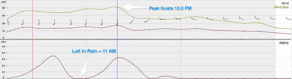
Updated Mon 08:41 AM — Latest HRRR model forecast for Fort Washington/Blue Bell:
Lull in the rainfall about 11 AM, then thunderstorms move through:
Peak wind gusts expected 12-2 PM:
Click on image for larger view:

Updated Mon 08:41 AM — Latest HRRR model forecast for Fort Washington/Blue Bell:
Lull in the rainfall about 11 AM, then thunderstorms move through:
Peak wind gusts expected 12-2 PM:
Click on image for larger view:
Somewhat good news: Last night’s GFS has brought the wind gust forecast to a generalized 60 mph, with these levels occurring around noontime. (None of those 80 mph levels.) The most recent HRRR is still in the 68 mph wind gust range with similar peak timing. The NAM-NEST has backed off to the 56 mph range.
(Wind gusts is a parameter that models aren’t really the best at getting right. So the gust forecast shouldn’t be taken as literally as temperature forecasts.)
There is expected to be a line of thunderstorms developing ahead of a cold front. This line of thunderstorms is expected about 1-3 PM. (Blue Bell). Rain tapers after the frontal passage around 4-6 PM.