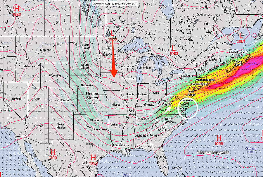
Update Fri 08/19 @ 10:43 AM — Here’s the update I had planned to provide last night. 🙄
The overall forecast is playing out as expected. Low pressure will develop and move off the Virginia coast Saturday, missing our area. A second low in the Minnesota will move in late Sunday and Monday—
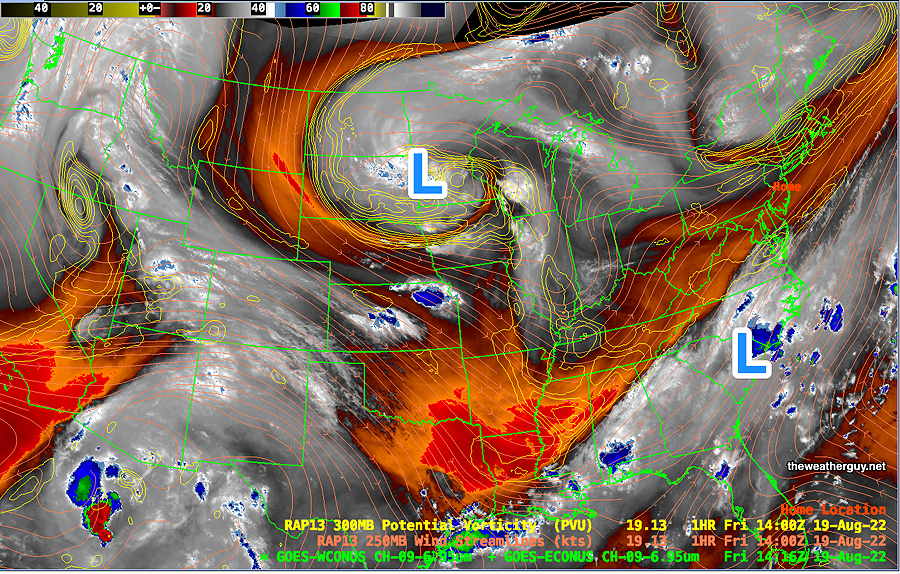
Friday morning: Current water vapor with RAP model contours. (Click on image for a larger view.)
Saturday looks good with some scattered clouds.
Some uncertainty whether some light showers move in mid to late afternoon on Sunday or whether it holds off until the evening hours as the second low approaches from the west. Increasing humidity over the weekend, especially by Sunday.
Models crank out anywhere from 0.5- 1″ of rain for late Sunday through Monday. Will have to see… These dry spells are tough to break.
More Moisture–> More Rain?
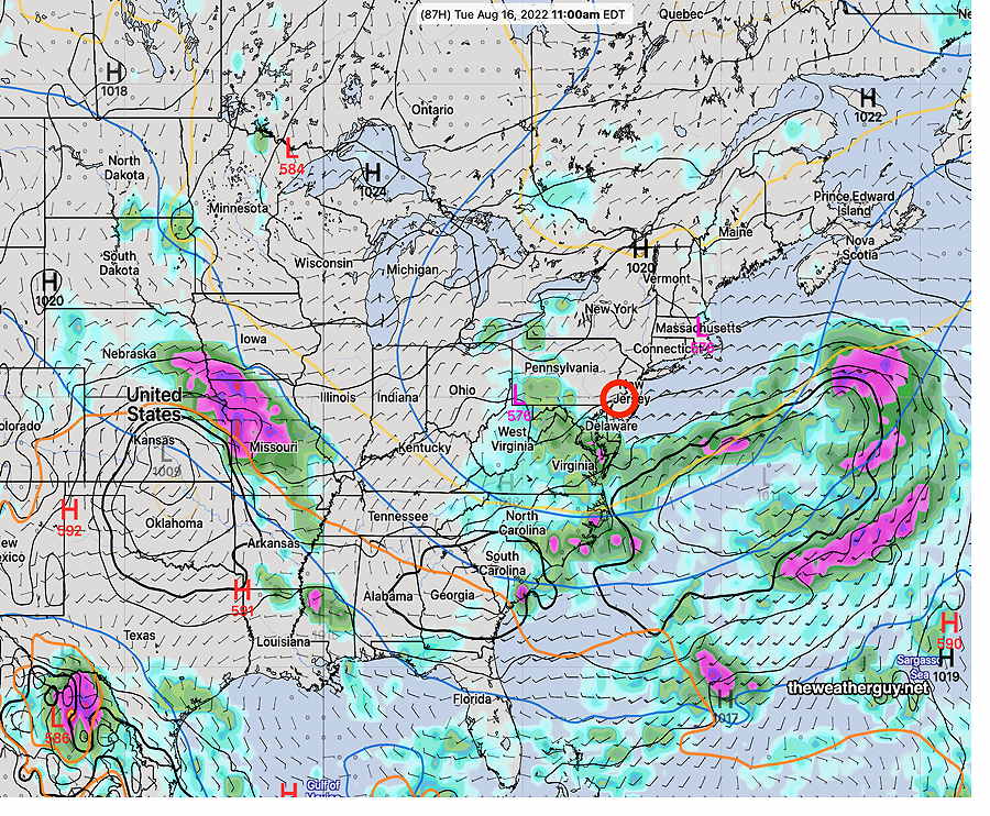
Update Thu 08/18 @ 8:31 AM —A stationary front to our south will slowly move north as a warm front over the next few days.
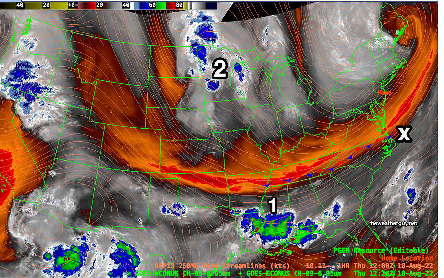
WV image Thursday AM with stationary front (drawn) to our south. Disturbance # 1 will move to area X and then offshore on Saturday. Disturbance #2 will move in late Sunday into Monday. Increase in clouds, heat and humidity. (Click on image for a larger view.)
An increase in showers and humidity over the next four days, but diffuse weather pattern will make timing in advance difficult. As mentioned in previous day’s posts, the models are showing best chance of showers here Monday into Tuesday, BUT latest GFS keeps parts the Delaware Valley dry! I’ll update Thursday evening.
Pop up showers possible late Wednesday afternoon
Updated Tue 8/16 10:57 PM —A change in Wednesday’s forecast based on tonight’s models. Low pressure affecting Maine tomorrow will rotate some upper air disturbances through our area late Wednesday afternoon with some scattered pop-up showers and a fewweak thunderstorms. Likely time is between 4:30 and 6 PM. Not all areas will see rain.
Little chance of rain
Updated Tue 8/16 5:47 PM —Our San Diego type weather will continue. Unfortunately, the trees and flowers are getting thirsty.
The earliest chance of rain appears to be late Sunday afternoon or evening. (Some areas far northwest will see some brief showers Wednesday evening.)
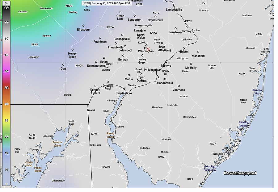
So what is the chance we’ll see more than 0.10 inches of rain Sunday evening? —
NAEFS 6 hour rain probability of more than .10 inches of rain 2 PM- 8 PM Sunday. Large areas will receive less or nothing. (Click on image for a larger view.)
FYI, this is a probability for a six hour period. Typically, in non-drought situations, a probability of at least 25-30% in a six hour period usually means some rain.
OK, that was for 0.10 inches.
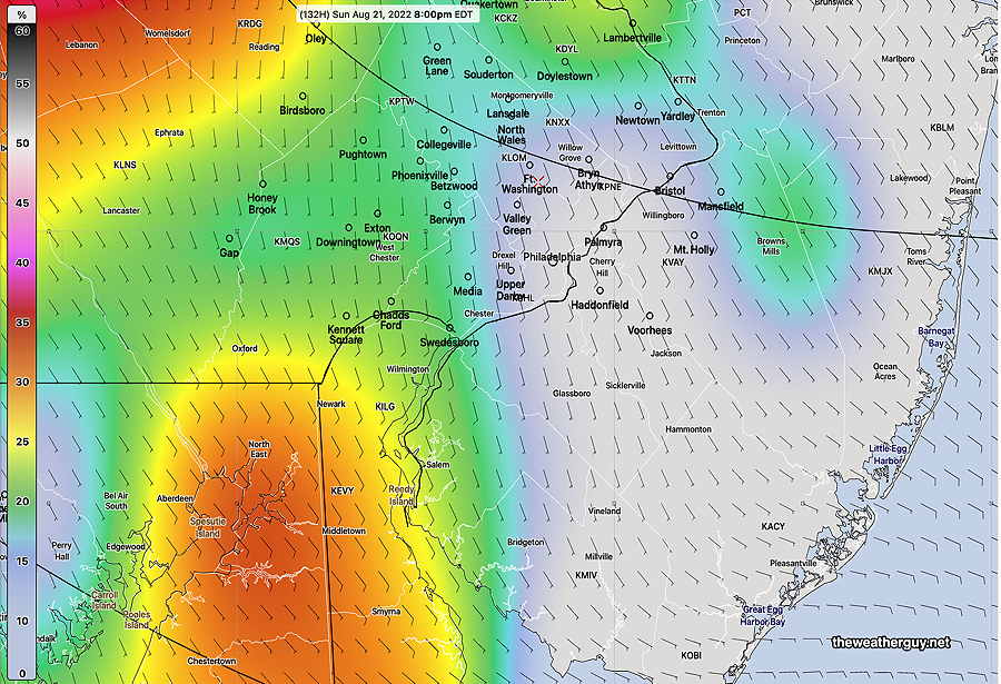
What about the chances for greater or equal to 0.25 inches of rain Sunday evening?—
NAEFS 6 hour rain probability of more than 0.25 inches of rain 2 PM- 8 PM Sunday. Most areas will receive less than 0.25″ (Click on image for a larger view.)
Addendum Tue 8/16 8:04 PM —Reviewing today’s GEFS, ICON and GFS, there’s a strong signal for some substantial rain early morning hours next Tuesday.
Dry until the weekend
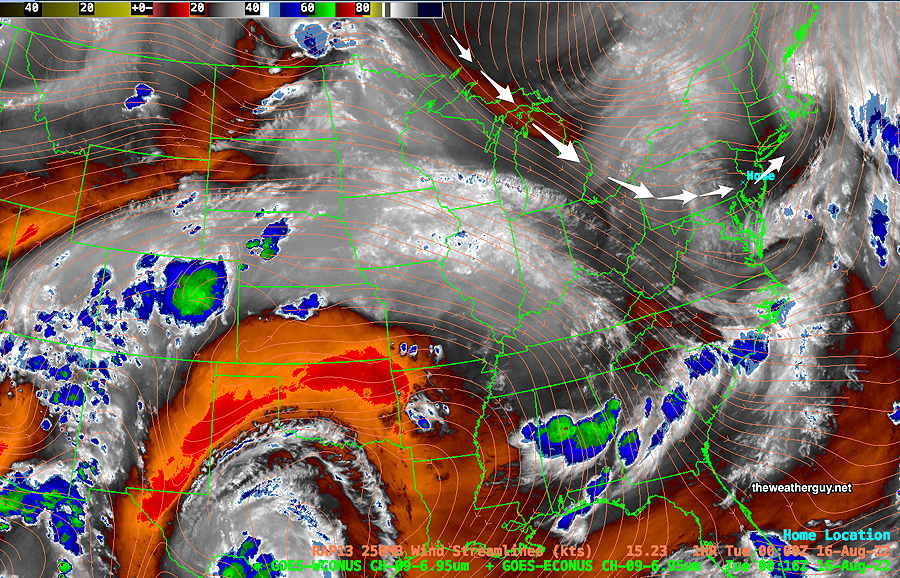
Update Mon 08/15 @ 8:56 PM — A dry flow aloft and an easterly wind at the surface will keep things dry and pleasant through Friday. The weekend may have some light showers. We may need to wait until late Sunday or next Monday for some rain.
Current water vapor image with 250 mb (jet stream level) wind contours (orange lines) shows a dry flow over our area that may persist through Friday. White arrows show the flow over us(Click on image for a larger view.)
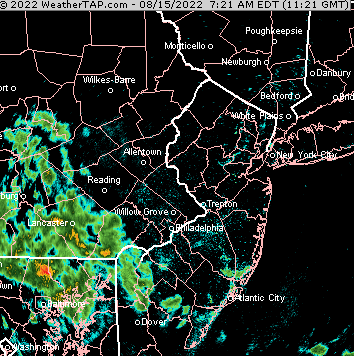
Update Mon 08/15 @ 9:12 AM — The showers have made it closer to Philadelphia than last night’s models had forecast. The models still have them falling apart as they move closer.
NEXrad radar loop 8 AM Monday. I always get a kick out of the TV weather people’s expression “we’re tracking the storms” Weather is not like a a commuter train with “next stop, Philadelphia”. It’s a highly dynamic complex process. The above radar loop is a great example. At quick glance, it looks like the rain is on its way into the city. A can’t-miss situation. But the rain was hitting a dome of very dry air and the storms fell apart, as the models predicted. (Click on image for a larger view.)
Evolving Weather Pattern Change
Previously Posted Sun 9:54 PM —
As mentioned in my weekend post, the upper low pressure system that had been expected to provide some rain for us Monday and Tuesday will be positioned in a location that gives us little or no rain!
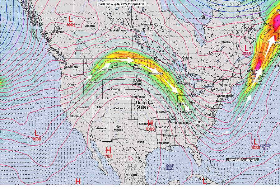
However, things appear to be changing further in the overall jet flow this week, with a new dip in the jet flow in the center of the country, positioning a jet streak just to our south by Wednesday—
NAEFS forecast for Friday morning. Upper low drops southward in center of the US. Right entry region of jet streak (white circle) Moisture flow comes up form the southwest. (Click on image for a larger view.)
With all that, the southeastern US looks to get most of the rain this week. Not much rain for us showing in the extended range…yet. Things are showing signs of change.
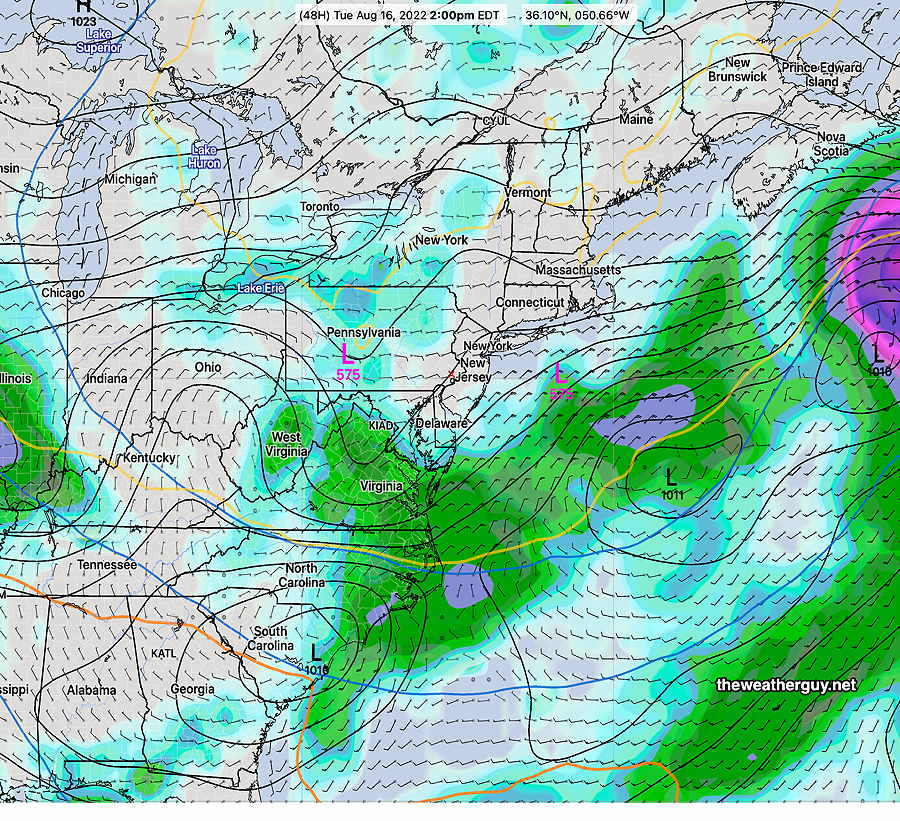
Here’s how things look for Tuesday–
GEFS Tuesday 2 PM forecast. Plenty of rain…just not around here. (Click on image for a larger view.)
Update Sat 08/13 @ 8:26 AM — We may be disappointed with the amount of rain that had been expected for Monday into Tuesday. The low pressure system and upper trough are forecast to set up in a position that would minimize precip in our area. The latest ECMWF captures it well—
ECMWF shows upper low with the rain mainly to our south, west and east; essentially the same pattern for the past two months. (Click on image for a larger view.)
Updated Fri 8/12 10:49 PM —It looks like we’ll have some cloudiness move in during the mid afternoon on Sunday, somewhat earlier than previously forecast.
Previously Posted Fri 5:46 PM —
This weekend, we’ll be under the influence of a cool, low humidity high pressure system that has pushed the jet flow into a trough pattern. We haven’t seen a trough pattern here for many weeks—
GEFS (mode) 250 mb winds showing rather deep trough over the eastern US. (Click on image for a larger view.)
The forecast for this weekend will be relatively simple. Mostly fair skies and low humidity.
Following the weekend, the same upper trough will produce unsettled weather.
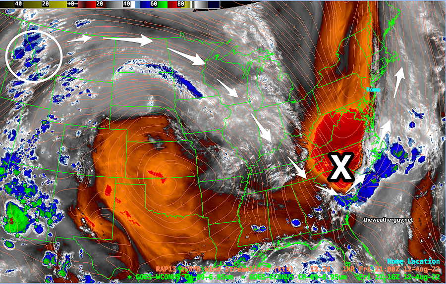
As shown in the current water vapor image below, an upper air disturbance in Idaho will move along the jet flow and develop into a surface low pressure system late Sunday evening through Monday and possibly lingering into Tuesday—
Current Water Vapor Image (Friday 5 PM) with RAP model jet wind contours shows upper air disturbance (blue areas in white circle) will move along the jet flow and spawn the development of a surface low pressure system (X) that may bring much needed rain Monday and possibly into Tuesday.
Saturday
Sunny and very pleasant. Breezy.
High temperature 81.3º ± 1.8º NBM model Blue Bell, PA
(Seasonal average high 84º Blue Bell, 85º Philadelphia)
Sunday
Continued sunny and pleasant. Light winds. Increasing cloudiness late afternoon and early evening.
High temperature 82.7º ± 2.5º NBM model Blue Bell, PA
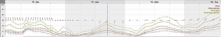
19z NBM Wind Meteogram for Blue Bell, PA (Click on image for a larger view.)