Weekend Weather & This Week’s Weather returns April 30th.
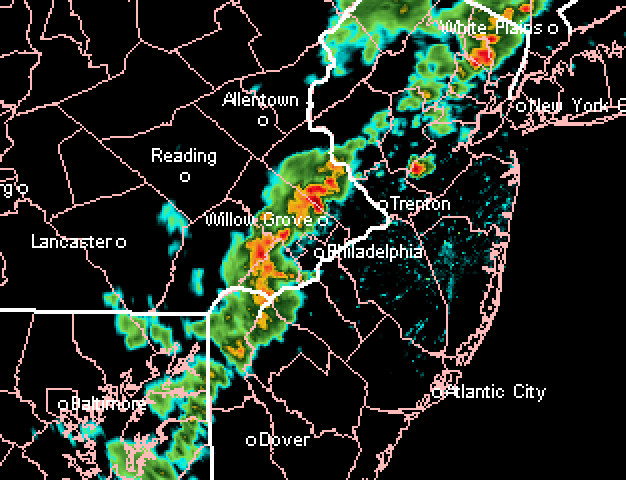
Thu 5:30 PM Forecast Review— We had the wind gusts and some areas had strong storms. The HRRR did pretty good forecasting the stronger storms north of Philadelphia.
NexRad radar loop about 5 PM. Courtesy of https://weathertap.com
Update Thu @ 10:15 AM — Some changes in the forecast with the latest HRRR just available. Timing of the frontal passage today is about 5 PM ± 1.5 hours in the immediate Philadelphia area with thunderstorms, then passing into NJ.
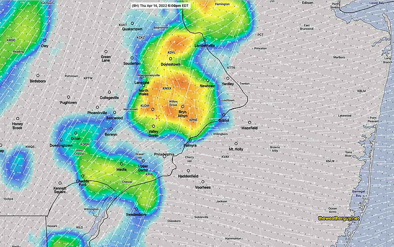
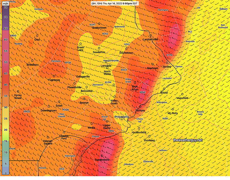
Today’s 12z HRRR simulated radar forecast for 5 PM. Shear vectors (long white arrows) are perpendicular to storm motion vectors (short white arrows), reducing chances of severe storms. Nonetheless, strong pressure changes and other air motion will result in high winds with the front itself. (Please note: model forecasts of simulated radar should not be taken literally. The model location of a thunderstorm is a model simulation for a moment in time, not reality.) (Click on image for a larger view.) HRRR wind gust forecast for 5 PM today. (Click on image for a larger view.)
A rapid change in pressure with the frontal passage will result in high wind gusts, as the winds shift from southwest to northwest. Depending on the model, gusts from 30-50 mph possible.
Previous model runs showed shear and helicity to be low with severe thunderstorms unlikely. Despite this, the HRRR is showing an elevated hail parameter with the storms with strong vertical motion being present.
Update Wed @ 6:08 PM — A cold front moves through Thursday afternoon with thunderstorms. Current timing is between 2:30 and 5 PM depending upon the model. Here’s the NAM-NEST forecast for 4 PM—
NAM-NEST forecast for 4 PM Thursday afternoon showing simulated radar and CAPE (shading). A line of thunderstorms is forecast to move through between 2:30 and 5 PM. CAPE values in the orange shading are above 1000 J/kg which is respectable, allowing for some storms to be strong.
Forecast helicity and vertical shear remains low and CAPE values remain in the respectable moderate range. No severe weather expected although some strong thunderstorms are possible.
Update Tue @ 8:08 PM — Very warm weather for Wednesday and Thursday with high temps 80-84º. (Average high is 64-65º.)
A cold front moves through Thursday afternoon, with current timing about 5 PM according to the latest NAM-NEST. Thunderstorms are expected.
A low helicity and low shear environment is currently predicted, so severe weather is unlikely, although some strong storms always possible since CAPE values are forecast to be in the respectable low moderate range of 600 joules/kg range.
Update Mon @ 6:50 PM — A review of the latest GFS and Canadian RGEM are more optimistic than the high resolution models that the showers tomorrow morning will be light and depart mid morning. Huge difference here, so I guess we’ll see.
Warm temps and sun in the afternoon.
Update Mon @ 5:11 PM — The low pressure system that gave us the showers and clouds over the weekend will rotate yet another weak disturbance and front through on Tuesday. (The center of this low is still near Nova Scotia.)
The forecast has changed from yesterday— what had been forecast to be a light sprinkle moving through early to mid morning Tuesday now looks to be a several hour period of showers, possibly lasting a bit past noon time. Total QPF is on the order of 0.15 inches.
Previously Posted Sun 7:32 PM —
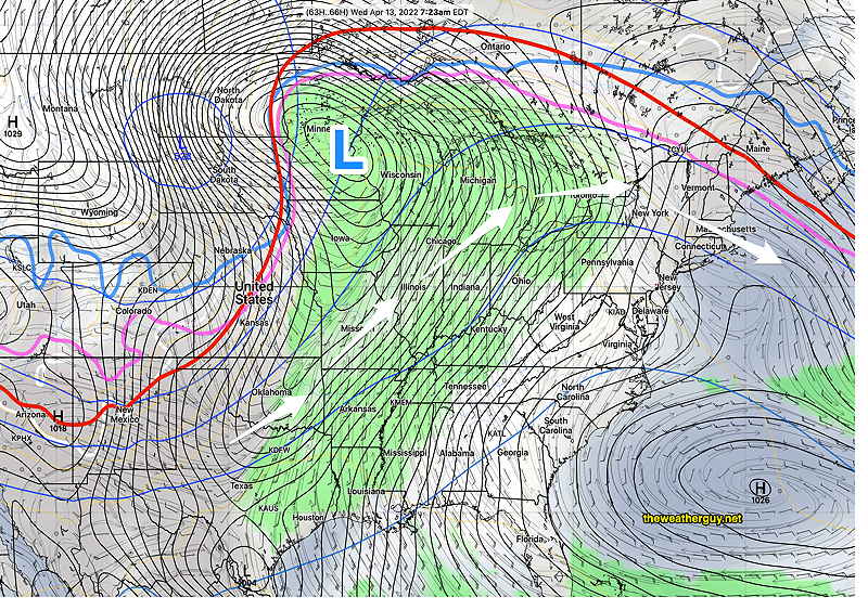
Our weather will turn more spring-like this week as we come under the influence of an upper level ridge with warm air moving up from the south—
GEFS forecast for Wednesday morning. We’ll be under the influence of an upper ridge and a warm southwesterly flow. Temperatures will move into the 70’s and perhaps approach 80 Thursday, according to the NBM. The deep low in Minnesota will move into Canada and the cold front will dissipate as the low moves more northward. (Click on image for a larger view.)
We’ll have temperatures in the 70’s by mid-week and possibly higher. The cold front that will be causing severe weather in the middle of the country is expected to weaken considerably as it approaches us Friday.
No major storms expected this week for our area. Some showers Monday night will move out by Tuesday.
Update Sat @ 9:56 PM — For Sunday, today’s models show a significant amount of mid-level cloudiness developing towards noon Sunday and dissipating mid to late afternoon. There will still be plenty of breaks sunshine. It will be windy and chilly; the high temperature of 51° will be reached late in the day.
There’s even a chance of more sprinkles in the late afternoon, especially north and west of our area.
This cloudiness is the result of continued instability and a stream of upper air disturbances passing over us, rotating around the departing upper air low.
GFS 500 mb vorticity at 3 PM Sunday. The western back edge rotates through our area about 4-5 PM, allowing clearing (Click on image for a larger view.)
A deep upper trough over our area will bring unsettled conditions on Saturday and cooler than seasonal average temperatures. The trough gradually moves away on Sunday, but still affects us. A upper ridge with milder temperatures moves in next week.
Saturday
The upper trough will result in considerable instability cloudiness and showers. Showers will be widely scattered, more numerous early morning, then breaking out, scattered again, in the afternoon. There may be significant sun late morning before instability clouds develop.
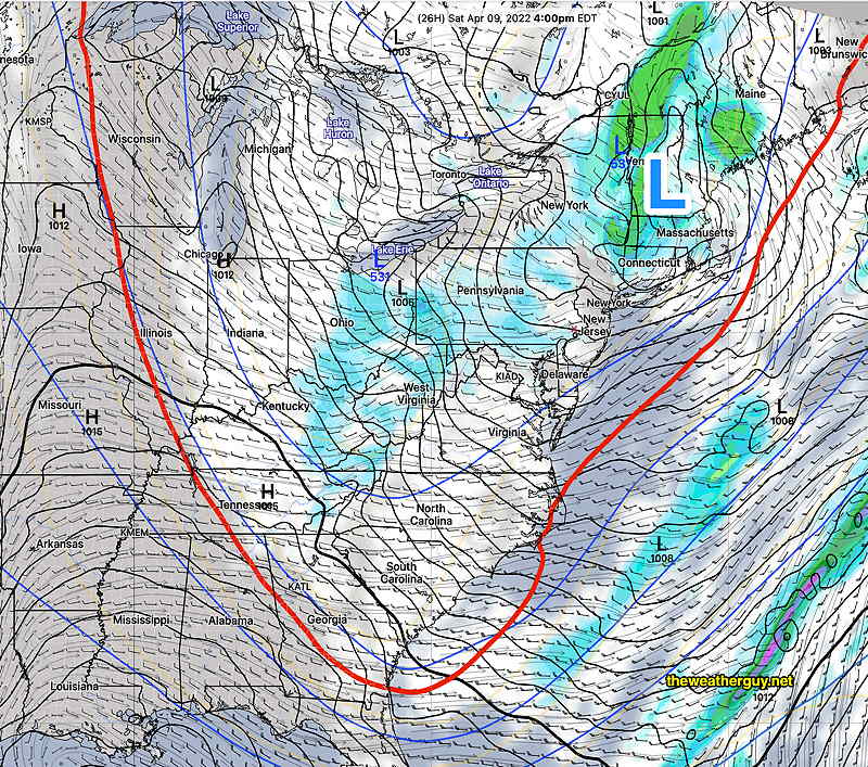
Today’s 18zNAM forecast for 4 PM Saturday. A low pressure system over Vermont and an upper low over Lake Erie with a deep trough, indicated by the red 540 thickness line. Showers and clouds over our area. (Click on image for a larger view.)
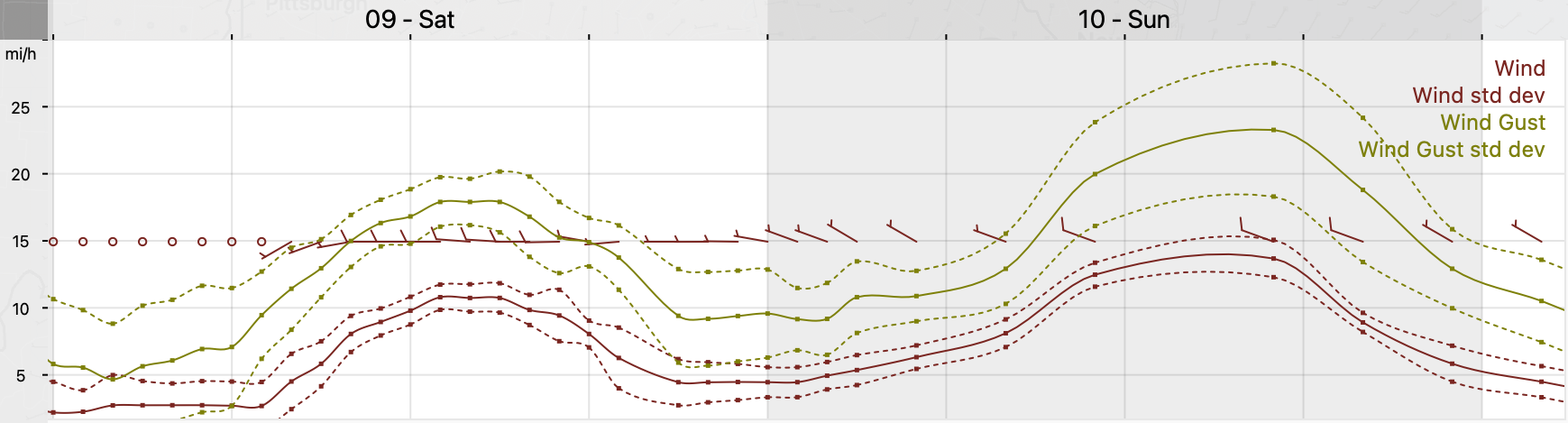
A mix of clouds with breaks of sun, not very different than last Saturday. We’ll have widely scattered showers, especially in the afternoon. The cold air aloft may again result in some frozen form precipitation (graupel), much like last weekend. WINDY at times. High temperature 53.3º ± 2.1º NBM model, Blue Bell. (Average seasonal highs are 60-61º)
Sunday
The trough begins to lift, but the cold air will still be over our area.
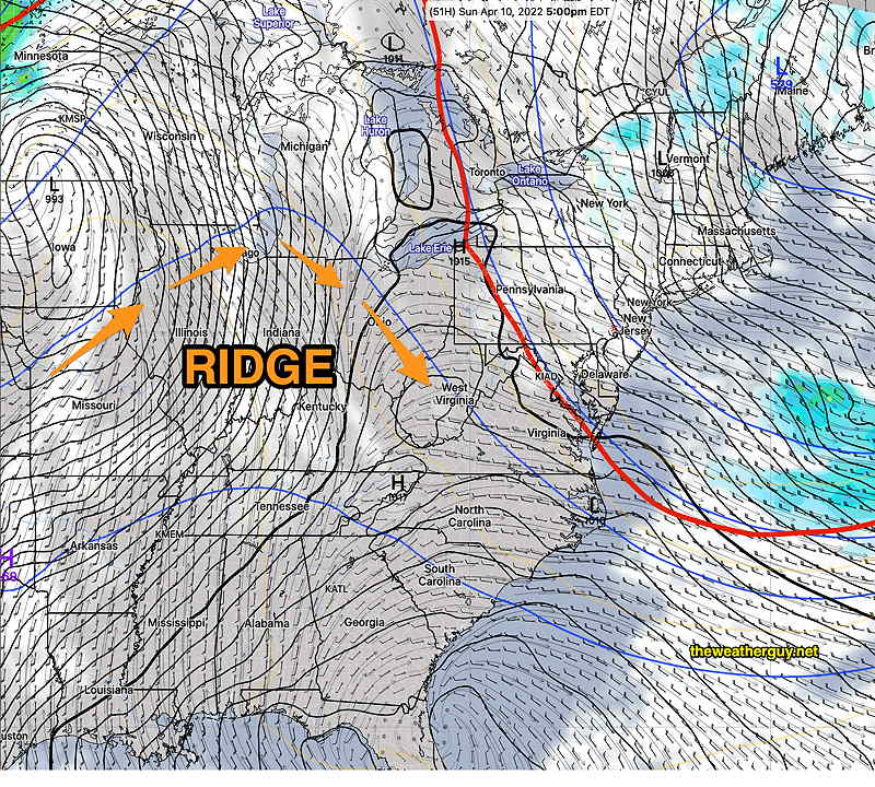
Today’s 18z NAM forecast for Sunday at 5 PM. Surface low still over New England, upper trough (red line) moving up and away. Some clouds but dry weather here. Upper ridge poised to move in from the west for next week. (Click on image for a larger view.)
Mostly sunny skies with still cool temperatures. Gusty winds at times. High temp 50.3º ± 2.0º NBM model, Blue Bell.
A ridge moves in next week with warmer temperatures.