THIS WEEK’S WEATHER

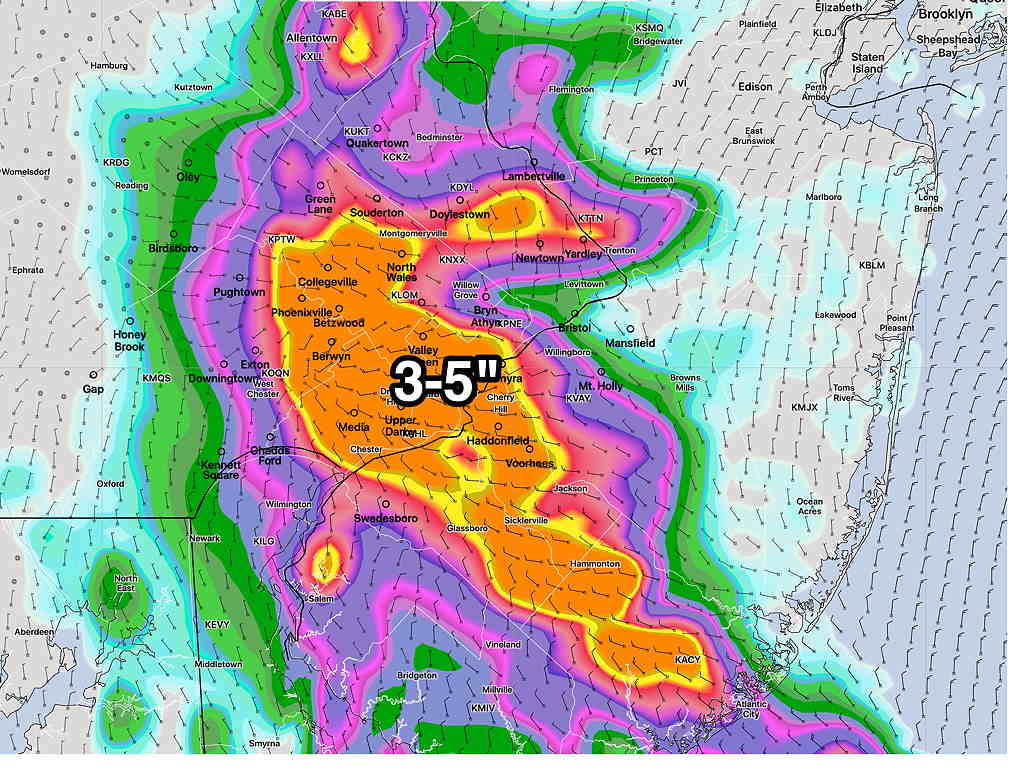
Thu 10:30 PM — Tonight’s models just becoming available shows heavy thunderstorms developing Friday between 4 PM and 8 PM and continuing into late evening as the cold front mentioned in my Wednesday update tries to make further progress southward.
(The HIRESW-ARW has storms as early as 2 PM)

High CAPE values and high PWAT will make for strong storms and heavy rain.
Saturday looks rainy according to the latest NBM. My regular weekend weather forecast will cover the details.


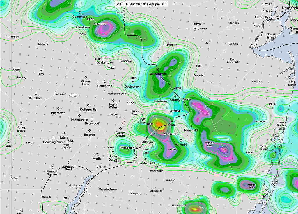
Thu 6:50 AM — The GFS, RAP and HRRR have backed away from numerous showers/thunderstorms this evening. Still some scattered around. The HI Resolution models and NAM still have showers as shown in last night’s graphic..


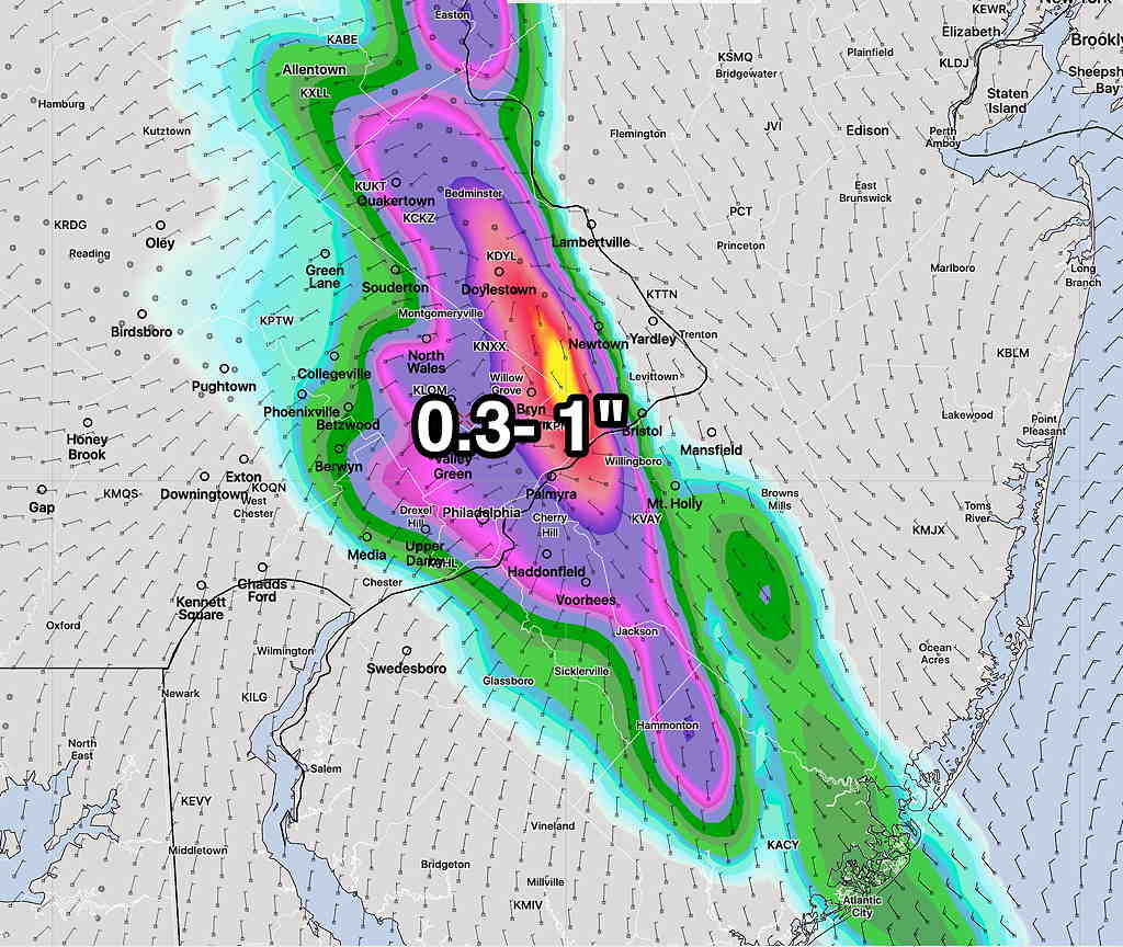
Wed 8:02 PM— Thursday’s forecast has come into somewhat better focus as a weak front will try to get its toe in the door late Thursday with little success as it’s pushing against strong upper level high pressure entrenched over much of central and southeastern US. Today’s models have some showers and possible thunderstorms in the Philadelphia area late Thursday afternoon as the front tries to move through. Most, but not all, of the activity is is currently forecast to be north and northeast of Philadelphia.

HREF 1 hour rain forecast for Thursday at 7 PM. Just a single time snapshot. Any storms break out as early as 4 PM in some areas. (Click on image for a larger view.)

A slight change in wind direction on Friday; the front will make another attempt to move through Friday evening with more showers and thunderstorms, likely more prevalent.

The weekend weather outlook still looks uncertain, but a mix of clouds, some sun and showers/thunderstorms is the most likely scenario for Saturday as the front hangs up somewhere near us. Sunday looks to be the better day.

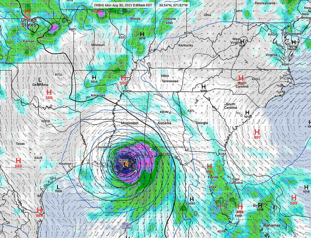
Also on the horizon is another tropical storm that the GFS is forecasting to become a hurricane in the Gulf and approach the US coastline, possibly Louisiana, as early as Monday.

Current GFS Forecast 2 AM Monday (Click on image for a larger view.)

Tue 9:16 PM— After the ‘exciting’ weather from Henri, this week’s weather will be relatively unexciting, as a large high pressure ridge in the upper atmosphere continues with the high heat and the humidity—

GEFS jet stream (250 mb wind/height) forecast for Saturday (Click on image for a larger view.)

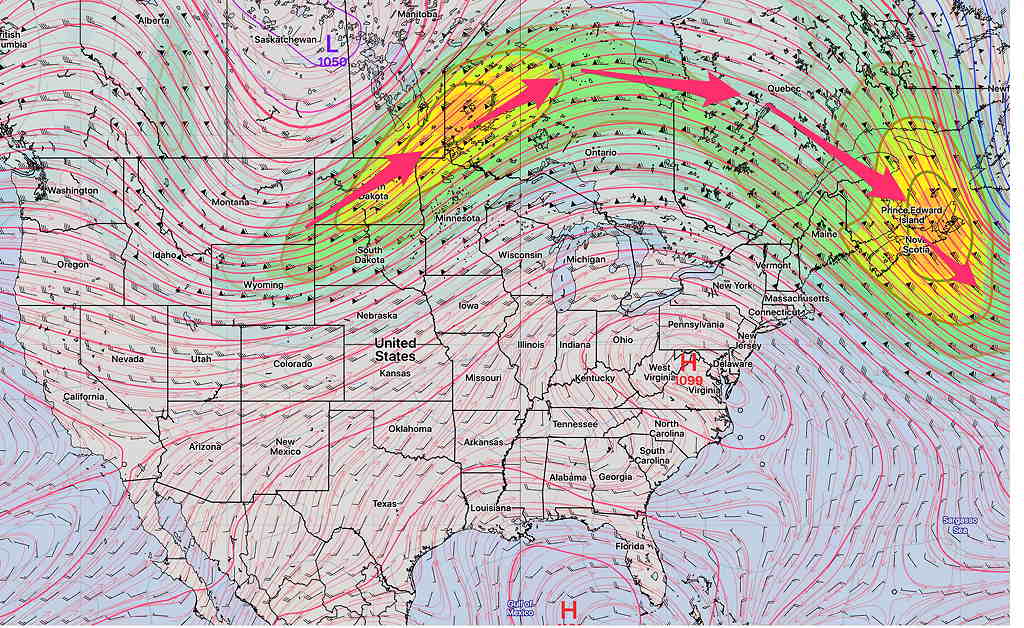
There really isn’t any sign that crisp cold air from Canada will descend upon us any time soon.

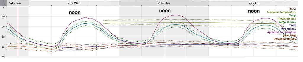
Wednesday through Friday appear to be hot and humid (although without the mid 70s degree dew points we have recently had). It will still feel very hot.

A meteogram is worth a thousand words. Here’s the NBM Temp/Dew point/Heat Index (“Apparent Temperature) for Blue Bell this week—

NBM model meteogram for Blue Bell. Wed-Fri. Note that the near 100º is the Heat Index (in the model world, known as the “apparent temperature”) Also included is the standard deviations. (Click on image for a larger view.)

While the general pattern is for continuation of hot/warm weather, small ripples in the upper air flow will result in possible thunderstorms Thursday late afternoon (especially far north) and Friday evening.

Following a cold front Friday evening, high pressure will try to move in over the weekend. Unfortunately, it appears that the main high pressure system will remain in Canada and we’ll get some easterly winds as the front stalls somewhere just to our south. That means somewhat cooler weather, but it also can mean some clouds and some showers.

The weekend forecast is too uncertain at this time to even try.

SUNDAY FORECAST UPDATE

Sun 6:30 PM Forecast Review — The forecast for Henri was a moving target for the past few days. Looking back, here’s what’s prominent: the GFS probably was the most consistent with the track. The Canadian and German ICON’s westward track was plain wrong and for a time, adversely influenced the official forecasts.  The areas of maximum rain Saturday night were close but still incorrectly placed. Last night’s NBM forecast for continuous rain here on Sunday was wrong.  Of the shorter range forecast models, the new HIRESW-FV3 probably did the best    

TROPICAL SYSTEMS NOW HAVE THEIR OWN WEB PAGE— Henri.
Hurricane Henri Forecast Updated Sat 11:15 PM here
The previously posted Weekend Weather Forecast is here


Forecast Update Sun 12:06 PM — The latest GFS just available shows the same lull in the precipitation for much of the rest of the daytime today as rain rotates around the upper low. The moisture source is an outflow band from Henri.

Water Vapor with superimposed GFS jet level wind streamlines showing moisture moving in north of us today. (Click on image for a larger view.)
Radar (MRMS- Multi-Radar Multi-Sensor from NOAA) showing the curvature of the precipitation will keep the precipitation chances low in Philadelphia for the balance of the daytime hours; the rain is rotating around our area. The western edge of this moisture plume will move back in about 3AM as the entire upper air low moves northeastward. The main precip shield of Henri is visible. (Click on image for a larger view.)

Rain moves in again about 3 AM Monday, similar to the NBM meteogram in the previous update.

Total additional rain is now about 0.8 inches, according to the GFS.


Forecast Update Sun 10:55 AM— With on and off rainfall now predicted through Monday morning, a NBM meteogram is the best way to convey the rainfree periods and most likely time for additional rainfall—

NBM 12z meteogram showing likely times of rain and thunderstorms (Blue Bell, PA) Anything greater than 17-18% (red line) is a good chance when working with 1 hour probabilities. (Click on image for a larger view.)

Forecast Update Sun 8:20 AM— Here is the current radar-based rain accumulation so far with this storm —

Radar-based rain accumulation totals as of 8:15 AM Sunday. There were areas of 3-6 “ of rain that has already fallen.

Note that the banding of the heaviest rain was north and east of where the models had predicted where the heaviest rain would fall. That’s probably as a good as they can do.

The latest NBM still shows considerable rain for today into early Monday, as the tropical moisture from Henri is expected to move in from the northeast. Areas north of Doylestown and near Allentown are predicted to have significantly more than 1 inch of rain additional.

NBM additional rain through early Monday morning.


Forecast Update Sat 10:38 PM — Tonight’s models just becoming available show a band of heavy rain to affect the Philadelphia area tonight. Current radar shows this moisture plume already working it’s way in.

With the exception of the NBM, most of tonight’s models have the heavy rain falling after midnight tonight and tapering off during Sunday morning.

Here are several of tonight’s models. Most have very heavy rain in the 3″ range except for the new HIRESW-FV3 which is based more on the GFS. (The actual GFS won’t be available until 11:44 PM, past my time on duty.)

It should be noted that the latest ICON model from this afternoon had backed down to 1.1″. While the amounts below are impressive, I’m not totally convinced that they’re not over-predicting rain.

NBM Rain Accumulation forecast through Sunday evening. (Click on image for a larger view.)
HRRR Rain Accumulation forecast through Sunday evening. (Click on image for a larger view.)
RAP Rain Accumulation forecast through Sunday evening. (Click on image for a larger view.)
NAM Rain Accumulation forecast through Sunday evening. (Click on image for a larger view.)
HIRESW-ARW MEM2 Rain Accumulation forecast through Sunday evening. (Click on image for a larger view.)
HIRESW-FV3 Rain Accumulation forecast through Sunday evening. (Click on image for a larger view.)

While it is clear that Hurricane Henri will not directly affect our area, there remains much uncertainty about the moisture flow when the tropical system enters Long Island and becomes an “extratropical” system.

There is currently a HUGE range of predicted rainfall in the Philadelphia area for Sunday.

The GFS model has close to 1 inch of rain falling Sunday in our area. The latest model blend (NBM) has 3-5 inches of rain, while the HRRR and RAP are in the 2-3 inch range. The NAM-NEST has less than 1 inch. The ICON has 1.1 inches and the Canadian GEM has 1.1 inches.

With the recognition that today’s showers were over-forecast, I’m going with the 1 inch and below range of rain through Sunday. But things could change.

The new models become available about 9:35 PM through midnight. I’ll update sometime after 10:30 PM.