The heaviest precipitation was expected to be just south of PHL and the precipitation cut off north of PHL is sharper than I would have guessed today.
(I use KPHL, the gridpoint for Philadelphia airport for my data. Several data packages, especially the NAM FOUS are specific for this grid point. It usually serves me well, but not with a sharp cutoff like today.)
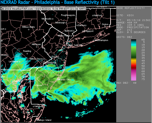
So, I’ve been waiting for something to fall from the sky today and here in the northwest part of city, we’ve had nadda. But radar shows precipitation just south of the city.
Current Radar, courtesy of Weathertap.com
The latest NAM data (for KPHL) has gone back to a low QPF, about 0.11. If we’re going to see anything, it would be between now and 9 PM.
Last night’s 2 AM run of the models continued with the changed forecast I posted last night–The precipitation arrives in Philadelphia this afternoon (instead of this evening and Sunday). Coastal storm development occurs later and further out to sea, so we don’t get any moisture thrown back on us on Sunday.
Upper air profiles support the formation of snow in PHL, but air temperatures near the surface and ground temperatures too warm for accumulation, except maybe on grassy surfaces. So expect snowflakes this afternoon, but little if any accumulation.
It should be noted that both the NAM and GFS support this new forecast. But the CMC (Canadian Model) still has a coastal storm forming close to us. Thought I’d just mention this; I don’t usually put much stock in the CMC.
Sat 10AM Update: Latest NAM data show’s 0.29 inches QPF falling this afternoon and evening, tapering later this evening. Upper air thermal profile supports snowflakes, but air surface temperatures expected to be above freezing and ground surface temperatures definitely above freezing.
We’ll see some wet snow this afternoon, but expect little or no accumulation on roadways. The best type snowfall- nice to look at but little to no accumulation. Maybe some grassy surface accumulation tonight.
The NAM has a few very light snow flurries Sunday.
1 PM Update: Heaviest precip will be just south of PHL this afternoon.
5PM update: The precipitation is barely making it north of PHL airport this afternoon.
With the change to daylight savings time, the evening model data now comes in an hour later.
The latest NAM shows a significant change in the forecast. Essentially, high pressure suppresses the moisture to our south, allowing most of the precipitation in areas just south of PHL. It will be very wet snow or snow mixed with rain in PHL. Little accumulation if any.
Additionally, the moisture arrives earlier, on Saturday during the late morning and afternoon , so light showers or showers mixed with snow is all we get tomorrow afternoon and early evening. Surface air temperatures and ground temperatures really too warm for any accumulation. Perhaps a coating or so on grassy surfaces. The total QPF is less than 0.10 inches.
Sunday looks to be just cold and a mix of sun and clouds.
The GFS data is just becoming available at 11:30 PM and seems to support the NAM forecast, although its QPF is about 0.20 total.